February 2022 was dominated by particularly wet weather, which included Storms Dudley, Eunice and Franklin. My days out were limited to a recce for a Sheffield U3A Geology Group field trip, the field trip itself and a further exploration of Broomhill in Sheffield – including brief surveys of Kersal Mount and Tapton Hall.
A week later, in the first week of March, I set off again with Paul and Dave from the Sheffield U3A Geology Group to undertake a recce for our next field trip on 16th March in Doncaster – this time involving visits to Cedar Road Quarry, Warmsworth Park and the Nearcliff Wood Quarries.
The bad weather in February, which led to our field trip being abandoned, had improved slightly but we had still been unable to prepare an itinerary for the year, so again I resorted to various sites that I had encountered when surveying the RIGS (Regionally Important Geological Sites) in Doncaster, firstly in 1997 and then in 2007, when producing the Doncaster Geodiversity Assessment.
Starting at the Cedar Road Quarry in Balby, I had a quick look to see how stable the access was to the exposure of glaciofluvial sand and gravel, which overlies the Triassic sandstone from the Chester Formation in this old building sand quarry.
When I last visited this site with the newly established XP School in Doncaster, in September 2015, the approaches to the quarry faces were quite overgrown. As we had done at Cadeby Rattles the previous month, we took some tools with us to do some clearance if necessary, but on this occasion we just needed to remove a few overhanging branches at the most interesting rock face, where a river channel with mudstone pellets is exposed.
Moving on to Warmsworth Park, another old quarry that had been used for the XP School field trip, we just had a quick look at a part of the western quarry face, behind planted shrubs. The partially obscured section exhibits massive limestone overlain by thinner flaggy beds, which both show noticeable lateral variation.
The main quarry face, although being progressively covered by ivy, still has plenty of exposures of the Sprotbrough Member of the Cadeby Formation, which differs significantly from the underlying Wetherby Member, which I had previously shown to the group at North Cliff Quarry and Clowne.
The Wetherby Member consists of massive beds that are very often oolitic, with shells of the brachiopod genus Bakevellia, with bryozoan reef masses being common along its length in South Yorkshire and further to the north; however, the Sprotbrough member contains no reefs or fossils and its primary texture has been obliterated by dolomitisation and large scale cross-bedding is a characteristic feature, with individual beds thickening and thinning rapidly.
Having already visited the sites on our field trip several times already, I had already identified the points of interest and I was more concerned with the parking arrangements for this part of the walk. With no on road parking in the immediate vicinity, I had always asked permission from the adjacent public house to use their large car park, but the owner of the new Indian restaurant on the site very uncharitably refused this, unless we all purchased an evening meal.
Moving on to Sprotbrough Lock to have lunch, we briefly stopped at the Church of St. John the Evangelist in Cadeby, where there are some interesting features relating to the dolomitisation of the limestone and one of the restored Corinthian capitals has decayed at an accelerated rate.
Parking at the northern end of Conisbrough Viaduct, which was planned as part of the walk that had to be abandoned the previous month, Dave explained the problems of building such structures - based on his experience as a civil engineer - and a quick look down to the River Don confirmed that the recent floodwater had not yet fully abated.
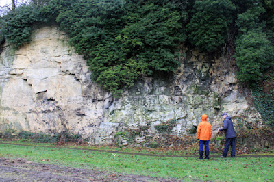
At the southern end of the viaduct, we made our way down a muddy path to the main footpath to Sprotbrough and then to the Nearcliff Wood Quarries, where there are some spectacular examples of slumping, cambering and rifts that are filled with glaciofluvial sand and gravel.
I have not seen such disrupted rocks anywhere else in the Cadeby Formation and this is probably associated with the North Don and South Don faults and the Don Monocline – a major structure that has controlled the north-easterly flow of the River Don from Sheffield.
 |
| Slumped limestone and a rift at Nearcliff Wood Quarries |


No comments:
Post a Comment