Monday, 12 December 2016

All Saints Church - A Norman Chancel


A general view of the south elevation of the chancel

Having briefly examined the Anglo-Saxon north doorway of All Saints church in Laughton-en-le-Morthen, the next oldest visible part of the church is the chancel - at the east end – and here there is a great mixture of building stones and architectural details, which record various phases of rebuilding and restoration.


A plan of All Saints church

The lower courses of the eastern part of the south side of the chancel, and its east wall, are built out of blocks of Rotherham Red sandstone and - above these – thin, irregularly shaped and sized blocks of yellow dolomitic limestone are laid to a similar height.


A detail of the masonry to the south elevation

Within the south wall, the flat buttresses and the remains of a door jamb and a round window indicate a late Norman date – c.1190 according to published sources - and are built of large blocks of dolomitic limestone, which weathers to a distinct grey colour.


The north elevation of the chancel and the vestry

The north wall of the chancel, although partially obscured by the 17th century vestry, is also built in large, regularly squared and coursed blocks of similar limestone - into which are set the remains of a round headed window and a buttress in the same Norman style.


A view of the east elevation of the chancel

During the late 14th century, the entire chancel was raised using similar limestone as part of the remodelling of the whole church with this stone, including the insertion of new windows to the south and east elevation, with the latter being restored by Sir George Gilbert Scott.


A general view of the chancel at All Saints church

Sunday, 11 December 2016

All Saints Laughton - The Saxon Church


The Anglo-Saxon doorway at All Saints church

When preparing an itinerary to visit various mediaeval churches set on or near to the Rotherham Red sandstone - having fully investigated St. Helen's church in Treeton - I was interested to discover that those at Todwick, Wales and Aston possess certain features that suggest that they could pre-date the Norman Conquest of Britain and All Saints church in Laughton-en-le-Morthen clearly has an Anglo-Saxon origin.

Anglo-Saxon and Perpendicular Gothic style architecture

Although set on an outlier of the Cadeby Formation, with various limestone quarries indicated on old maps and with the main outcrop of the Magnesian Limestone nearby, the Anglo-Saxon north doorway is constructed in what I always assumed to be Rotherham Red sandstone - the nearest source of which is more than 3 km away; however, looking more closely, the flame red stone used for a pilaster would not be considered typical of this distinctive variety of the Mexborough Rock.

Details of the masonry to the north doorway

Compared to ancient doorways that I have seen all around England, its construction is extremely crude - with little attention paid to the shaping of the individual stones – and its style strongly contrasts with the Norman doorway that has been built within it.

A general view of the north elevation of All Saints church

A stone's throw away from All Saints church, there are also the remains of a motte and bailey castle built by Roger de Busli - who was given this manor after the Norman conquest in 1066 - and which is believed to have been built on land previously owned by Earl Edwin of Mercia, the brother in law of King Harold Godwineson.

A view of the old motte and bailey and All Saints church

Saturday, 10 December 2016

Laughton-en-le-Morthen - Architecture


A gate to the garden of the Old Hall

Arriving in Laughton-en-le-Morthen from Dinnington, the bus passes St. John's church in Throapham before entering the outskirts of the village, where it is obvious that the building stone used here is Permian dolomitic limestone.


Vernacular architecture on St. John's Road

Walking along the main road to All Saints church, a variety of old agricultural and vernacular buildings can be seen, with limestone used for walls and dressings and clay pantiles for the roofs.


An 18th century house with a modern roof

In common with the various limestones seen in Rotherham and Doncaster, the Cadeby Formation contains beds of various thickness and quality that are differentially used for the various structural elements in a building, and these are evident in a wide variety of architectural styles.


Old Hall Farm with limestone walls and a Carboniferous stone slate roof

All Saints church, which attains a height of 56 metres and can be seen from 100 km away, is clearly built out of dolomitic limestone and - 100 metres or so to the south – there is a large, shallow quarry where a few exposures of massive limestone can still be found.


Geology and Architecture in Laughton-en-le-Morthen

Looking closely at a map that I discovered when researching the geology and old quarries around Laughton-en-le-Morthen, this is described as a sandstone quarry and it is quite likely that the Yellow Sands Formation – of great value for iron foundries – was principally excavated here. Although the overlying limestone was probably used for building stone, other limestone quarries are also found in the area.


Old agricultural buildings


Friday, 9 December 2016

Laughton-en-le-Morthen - Geology


The geology of the area around Laughton-en-le-Morthen

The geological map of the area around the ancient village of Laughton-en-le-Morthen shows that it is set on a small outlier of the Permian Zechstein Group, comprising the poorly cemented Yellow Sands Formation overlain by dolomitic limestone of the Cadeby Formation.

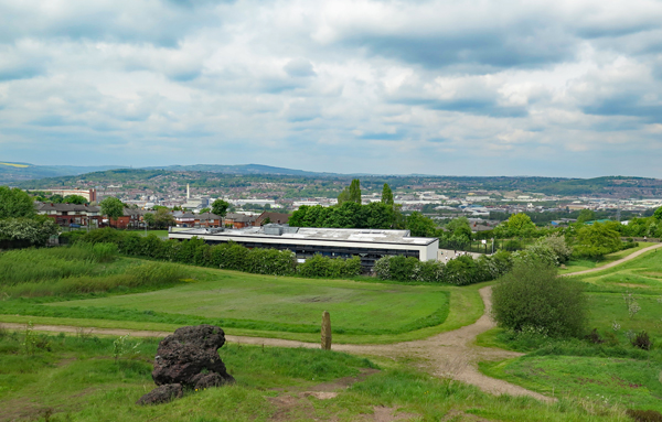
A view of Laughton-en-le-Morthen

In the landscape, this outlier appears like a small limestone capped island with an apron of weathered sandstone, whose slopes blend in with the surrounding gentle scarp and dip topography that is typically formed in the rocks of the Pennine Upper Coal Measures Formation.

A view of the landscape seen from Laughton-en-le-Morthen

When surveying many geological sites in Rotherham for the South Yorkshire RIGS Group, Laughton-en-le-Morthen wasn't highlighted for investigation, even though it possesses a Grade I Listed mediaeval church and that old quarries are likely to be found nearby - as I discovered in the villages of Harthill and Whiston.

An 1855 ordnance Survey map showing various quarries 

Having briefly explored the mediaeval churches of Beighton and Beauchief - as well as Sheffield Manor Lodge in Sheffield - I set off on a variety of buses to investigate Laughton-en-le-Morthen.

Wednesday, 7 December 2016

Sheffield Manor Lodge


Windows in the Turret House

The bus that I took from Sheffield Interchange to Sheffield Manor Lodge wound its way up the escarpment of Parkgate Rock, which rises up from a relatively low lying area where Sheffield castle was once located, and when alighting in the Manor Housing Estate, there was nothing to indicate the presence of an ancient monument here.

A view of the Turret House at Sheffield Manor Lodge

Having had to ask for directions a couple of times, my first glimpse of the Turret House came as a real surprise – seen through the gap between two 1930's council houses – but once orientating myself, I soon found the ruins of the manor house, built by the 4th Earl of Shrewsbury.

A general view of the South Range

The geological map of the area shows that it lies just above the Parkgate Rock, with the Turret House occupying relatively flat ground – comprising shale/siltstone - and the old manor house being set on a slightly higher outcrop of sandstone.

A general view of the old manor house

An old map shows that several quarries once existed in the vicinity and, judging by its name, it would appear that the Manor Quarry – excavated into the Parkgate Rock – was the main source of the stone used to construct its principal buildings.

An old map of Sheffield Manor

I haven't yet seen a natural or quarried exposure of Parkgate Rock but, looking at the remains of this once extensive structure, there is a familiar pattern of roughly coursed blocks of poor quality, fine grained sandstone used for general walling - with massive, coarse grained stone used for quoins and other dressings.

An old fireplace in the South Range

Whilst surveying some of the old villages in Rotherham, and their mediaeval churches, I haven't yet encountered any 16th century stone buildings and I was therefore very interested to see how its austere Tudor windows have weathered, compared to the various elaborate Gothic styles that I had previously seen.

The Turret House

The Geology of Sheffield


The basic geology of the area around the City of Sheffield

Looking at the City of Sheffield on the BGS Map Viewer at the 1:625,000 scale, it can be seen that it is located on a succession of an eastward dipping succession of Upper Carboniferous rocks - with Millstone Grit outcropping within the Peak District National Park to the west, Lower Coal Measures underlying its central areas and some Middle Coal Measures to the east.


Upper Carboniferous strata forming escarpments along the Don Valley

Located on the edge of the Pennines, an upland area of England eroded away by ice and glacial meltwater during the Quaternary Period, Sheffield is set on seven hills - like Rome - with several steep sided river valleys exposing successions of sandstone, mudstone, seatearth and coal. All of these, along with ironstone, were once widely exploited by the local steel industry and as building materials, but all mining and quarrying activities have now ceased.


A view of Sheffield city centre from Skye Edge

Having had to put my planned investigation of the mediaeval churches in Rotherham on hold – whilst waiting to hear from various key holders - and having briefly explored the geology and historic buildings in Beighton and Beauchief, I took advantage of a bright and sunny day to take my first look at Sheffield Manor Lodge.


The geological map of the area around Sheffield Manor Lodge

Monday, 5 December 2016

Archaeology at Beauchief Abbey


A layout plan of Beauchief Abbey

When setting out to thoroughly investigate St. Helen's church in Treeton, my principal aim was to revive my working interests in standing buildings archaeology, having undertaken surveys of All Saints church in Pontefract and Brodsworth Hall a few years ago - which I thought particularly suited my professional skills, experience and interests.


An old roofline to the east side of the tower


Whilst exploring the exterior of Beauchief Abbey, apart from studying the characteristics of the building stones, I saw various details to doors and windows and old rooflines, which give the archaeologist clues to its construction history and, when encountering a group of students in its grounds, I did wonder at what stage during their formal studies – if at all – they learn about the hard rock geology and the building stones that they are investigating.


A hand dug trench

Around the site, large fragments of moulded stone can be found lying about and, when looking at excavations of various old boundary walls and being requested to give my opinion on a large section of stone that had been uncovered – and which contrasted strongly with other fragments of stone that surrounded it – I was happy to advise.


A finely tooled section of stone found in a trench