Saturday, 13 February 2021

The Chesterfield Canal - Part 2

Arriving at the summit of the Chesterfield Canal at Thorpe Top Treble Lock, which is approximately 80 metres above sea level, having had one of the most enjoyable walks for a very long time, the second part of the walk to Kiveton Park station had less obvious attractions.
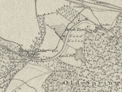
An old map showing quarry sources of building materials

Seeing only a derelict brick cottage through the trees here, with some rusting farm machinery, when later referring to the 1854 Ordnance Survey map I discovered that this area was a former brick yard, which dug marl from the Edlington Formation. I then came to the brick built mid-C19 Pudding Dike Bridge, which has an old quarry - erroneously described on the map as producing sandstone - immediately to the west of it.

Pudding Dike Bridge

Beyond this point, the Edlington Formation appears to the north as an expanse of agricultural land with distinctly red soil – a geographical feature that I had noticed when looking from the window of the train a few hours earlier.

Reddened soil on the Edlington Formation

When undertaking a survey of potential RIGS (Regionally Important Geological Sites) back in 1996, I was directed by the desk based researchers to investigate a potential exposure of the Edlington Formation near to the canal at Thorpe Salvin, but I didn't manage to find it. 

Devil's Hole Bridge

Carrying on to Devil’s Hole Bridge, which is the only stone built bridge that I saw on this stretch of the canal, I hoped that I might see a kingfisher or other wildlife but I had to be content with some very large dragonflies instead; however, I didn't even attempt to photograph them with the Canon Powershot G16 camera that I had with me. 

A glimpse of Anston Quarry in the distance

After a few more minutes of walking, I came within a short distance of the old Anston Quarry, which has no connection with the quarry that supplied stone for the Houses of Parliament, but I could only get a glimpse of an old quarry face in the distance.

An undulating landscape on the Cadeby Formation

Shortly after this, there is a break in the woodland to the south where the undulating landscape formed by the Cadeby Formation can be clearly seen and, just before Thorpe Bridge, the 1924 Ordnance Survey Map shows an old quarry, but I was not aware of it at the time.

Old quarries marked on the 1924 Ordnance Survey map

At Thorpe Bridge, there is a well made Peak and Northern Footpaths Society sign – the third that I had seen since starting my walk at Shireoaks – and further online investigation of these paths gave me a few ideas for further exploration around the Chesterfield Canal in the near future.

A well marked footpath at Thorpe Bridge

Wednesday, 10 February 2021

The Chesterfield Canal - Part 1

 
Browns Lock

Setting off from Shireoaks along the Chesterfield Canal towards Kiveton Park railway station, having quickly explored some of the historic buildings in the village, after a few hundred metres I came to Boundary Lock - added at the time of a restoration to remedy the effects of mining subsidence on the water levels of the Ryton Aqueduct.

Boundary Lock

I have very much to learn about the canals in Britain but, as a geologist, I am very aware of
William Smith's connection with them when he created the first geological map and, looking at the British Geological Survey Map Viewer, I was very interested to see that the Chesterfield Canal here follows the line of the Spa Fault - an important fault that I previously seen at Spa Farm in Treeton.
 
The position of Turnerwood on the Spa Fault

Crossing the River Ryton at the Ryton Aqueduct and walking up the towpath towards Turnerwood, the 1854 Ordnance Survey map shows a series of old quarries and lime kilns in the Permian Cadeby Formation to the south. To the north, the strata are downthrown and there is a noticeable drop down to Burnt Wood, which is underlain by marl of the Edlington Formation.

A view of the River Ryton

The map also shows various limestone quarries alongside the canal from the east side of Pudding Dike Bridge to the area around Kiveton Park station, which was once known as Dog Kennels, as well as a brickfield and a sand pit.

Limestone quarries on the 1854 map

I don’t know exactly where the materials used to build the locks and bridges along this stretch of the canal were obtained, but limestone, marl and sand - for stone masonry, bricks and hydraulic lime mortar – are all readily available from the Permian strata nearby.

Granite setts

At Bridge 37, hard wearing granite setts have been used to surface the road across the bridge and at very many of the locks, rows of setts have been embedded in the bank to enable the lock tenters to get a secure footing when opening and closing the lock gates.
 
Views along the Turnerwood Flight

Walking up the Turnerwood Flight of seven locks, trees on either side of the canal prevented me from getting a look at the surrounding landscape and I just enjoyed the steady walk along the towpath, which I shared with walkers, runners and cyclists of all ages.

A view across lowland formed by the Edlington Formation

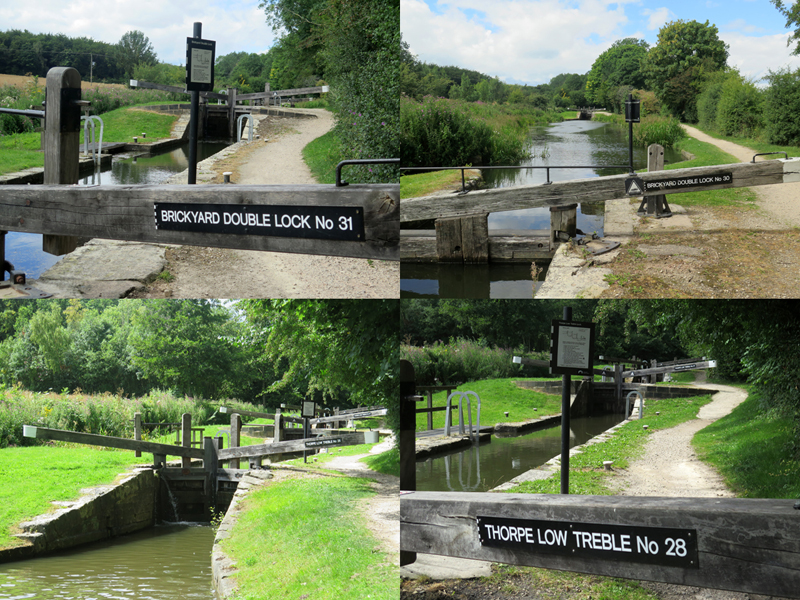
At Turnerwood, there are views down to the vale occupied by the Edlington Formation, with the higher ground in the distance formed by the Cadeby Formation and, carrying on up the Thorpe Flight of locks, I was interested in the name Brickyard Double Lock. The lock passes through the middle of the outcrop of the Edlington Formation here, where the marl is suited to making bricks, but I have not seen any evidence of this on old Ordnance Survey or LiDAR maps.
 
Views along the Thorpe Flight
 
Continuing futher up the Thorpe Flight, I encountered a boat that was just about to enter Thorpe Middle Lock, where I stopped to observe the various procedures required when operating the various gates and paddles.

Instructions for using a lock

I was particularly interested to see how long it took to pass through the lock, especially since 22 locks have to be navigated in ascending the 30 metres from
Ryton Aqueduct to Thorpe Top Treble Lock over a distance of approximately 2 km as the crow flies.

A boat entering Thorpe Middle Lock

This apparently takes about four hours today with lock tenters but, even if this is a bit quicker than with horse drawn boats, the time is quite negligible, given that a load of stone took on average two weeks to move from Anston Quarry to the site of the new Houses of Parliament in the 1840's - via the River Trent, the Humber, the North Sea and the River Thames.
 
Over 14000 cubic metres of limestone were sent to London for its construction, with 400 tons being shipped each month for the first few years. With many other commodities, including lead and coal, also being moved along the 74 km length of the Chesterfield Canal at the same time, it must have been a hive of activity – especially with boats also making the return journey.
 

Saturday, 6 February 2021

The English Houses of Parliament


A lion reproduced in Clipsham limestone

After briefly exploring the village of Shireoaks in the last week of July 2020, I finally got to walk along the section of the Chesterfield Canal, from Shireoaks railway station to Kiveton Park railway station, on a hot summer's day.
 
The approach to Boundary Lock

For more than 20 years, since meeting the historian Christine Richardson at the time she was preparing Yorkshire stone for building the Houses of Parliament (1839–c.1852) with Graham Lott, I had been aware of the importance of the Chesterfield Canal in this story, yet I had never seen it.
 
A view of the Houses of Parliament from Lambeth Palace

It was well worth the long wait and the last remaining piece of my story of the English Houses of Parliament finally fell into place although, as I write, the heavy snow and rain and the increased usage during the COVID-19 Pandemic has made many of paths quite treacherous and visiting it at the moment is not recommended. 
 
Photos of ornamentation by Derek Engering

Very many years ago, in the days when my late father worked as a carpet fitter at the Houses of Parliament – and a single unarmed policeman guarded the entrance on the south side of the Victoria Tower – I was given an informal tour of its interior and later saw the condition of the Anston stone in the unrestored inner courtyards, although I was never allowed to take photographs.
 
Statuary on the Victoria Tower

Later in life as a building restoration contractor in London, I always wanted to undertake work on this magnificent building but an opportunity never arose; however, when undertaking geological surveys for the South Yorkshire RIGS Group in 1996 and during subsequent professional work, I got to know the Magnesian Limestone very well.

An old face of the Anston Quarry in a back garden

The history of the construction of the Houses of Parliament using dolomitic limestone from North Anston and its subsequent restoration therefore particularly interests me. When working on the new displays for the refurbished Clifton Park Museum, I used my contacts to obtain a salvaged moulded section for the new geology display.
 
Various displays at Clifton Park Museum

During recent changes at the museum that involved the inexplicable replacement of some of the geological displays with various stuffed birds, this piece of Anston stone was for some reason removed from the attractive glass cabinet. Despite expressing my concern at this, to the best of my knowledge it is still hidden away in a drawer, where the built in lighting never seems to work.
 
A finial at Anston Memorial Garden

Although being informally consulted by the Surveyor of the Palace of Westminster, about building stones that might be used for future phases of restoration of its exterior, for which others have presumably been well paid, I now reserve my own opinions on this subject for my journalistic work and the occasional walks and talks that I give for various local history and conservation groups.
 
A view of the Houses of Parliament from the London Eye

Wednesday, 3 February 2021

A Brief Exploration of Shireoaks

 
Welcome to Shireoaks
 
By the end of July 2020, week 19 of the COVID-19 Pandemic, I had just about exhausted all potential walks to find some new geology and historic buildings, without making multiple bus journeys as I had done the previous year.

The Chesterfield Canal between Kiveton Park and Shireoaks

Earlier in the summer, I had walked along a short stretch of the Chesterfield Canal west of Kiveton Park station and I decided to go and further investigate the canal between the latter and Shireoaks – a small ex-coal mining village just inside Nottinghamshire.
 
Kiveton Bridge railway station

The only way that I could easily get to Shireoaks was by train and, taking advantage of the Sunday X54 bus service to Harthill, I alighted at the end of Kiveton Lane and walked along to Kiveton Bridge station, where I would catch the train that runs between Sheffield and Lincoln.
 
The former Station Hotel in Shireoaks

Surprisingly, there were quite a few passengers on the train but, keeping socially distanced by standing next to the doors and wearing a face covering, after a journey of only 8 minutes I arrived at Shireoaks station.
 
Terraced houses on Shireoaks Row

Access to the Chesterfield Canal is immediately to the south of the station but, making the most of being in this remote place, I walked down Shireoaks Row, where the brick terraced houses were built for the colliery workers, and had a quick look at the old village.
 
Shireoaks war memorial

I stopped briefly to photograph Shireoaks war memorial, which is sited in the churchyard of St. Luke the Evangelist, a Grade II Listed building in the Decorated Gothic style, which was built by T. C. Hine for the 5th Duke of Newcastle in 1863.
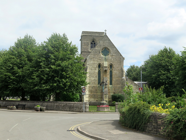
The west front of St. Luke's church

Dolomitic limestone from the Upper Permian Cadeby Formation at Steetley Quarry is used throughout the church, but I didn’t stop to investigate further and carried on along Shireoaks Road to look at a handful of vernacular buildings, which are built in limestone with red pantile roofs.

Vernacular architecture in Shireoaks

The oldest part of the village grew up around Shireoaks Hall, dated c.1600, which I didn’t get to see on this occasion but of these stone buildings, only the Grade II Listed former chapel, built c.1810 for John Hewett and which is now the Village Hall, has any architectural merit.

Shireoaks Village Hall

Returning to Shireoaks Row, after taking a quick look at the River Ryton, I was surprised to see the vicar and a few of the congregation outside St. Luke’s church and so I popped in to take a few quick photographs while it was still open.
 
The River Ryton

With my walk along the Chesterfield Canal still to be undertaken, I didn't go any further than the west end of the nave and, when I next retun to Shireoaks - to visit the Steetley Chapel and Shireoaks Hall - I will try and take a better look.

Views of the interior of St. Luke's church

Sunday, 31 January 2021

An Investigation of the Shire Brook


The Shire Brook in Wickfield Plantation

Having encountered various historic buildings in Intake, while walking down Mansfield Road, I continued up Hollinsend Road to Jaunty Park, where I started out on the main purpose of my walk – to try and find some geology along the section of the Shire Brook that runs from Hollinsend down to Normanton Spring.
 
A panoramic view of Jaunty Park

Walking across some often wild grassland into the valley formed in the Pennines Lower Coal Measures Formation, I turned round to look at the escarpment of Parkgate Rock, which here is cut by a fault with a downthrow to the north side.
 
Arriving at the Shire Brook, the banks were largely overgrown with thick undergrowth and I couldn’t see anywhere likely to have rock exposures. As with the upper parts of Shirtcliffe Valley, where I found a coal seam, the streambed was littered with blocks of stone, bricks and other materials from the Birley Vale Colliery, which was once located on the east side of the brook.
 
The streambed of the Shire Brook

I quickly walked down the path to Mansfield Road/Birley Moor Road where, just before it passes under the road, there is a large area of red ochre stained boggy ground, which had by now become a familiar sight during my investigations of various woods around Sheffield.
 
Ochreous staining in the Shire Brook

On the other side of the road, the path runs alongside a secure fence and, as I again later discovered, the brook is culverted here and the fenced off area is part of the former Birley West Colliery and the subsequent Normanton Spring landfill site - both of which are now restored.
 
Industry around the Shire Brook in 1906

Crossing Linley Lane and entering Wickfield Plantation, I finally found some rock outcrops in the streambed and banks of the Shire Brook, which once formed the boundary of the ancient kingdoms of Mercia and Northumbria and later between Derbyshire and Yorkshire.
 
A view down to the streambed of the Shire Brook

The thinly bedded sandstone here is the same one that I encountered at the roadside cutting at the bottom of Normanton Hill, with the bedding planes and an irregular pattern of oblique jointing being exposed along the streambed.
 
The streambed of the Shire Brook

Old maps show a disused quarry to the south side of the brook, but I kept to the footpath and didn’t see any evidence of this. The stone would have been used mainly for basic walling and, although flaggy, paving stones or stone roof tiles could probably not be produced commercially from this sandstone quarry.
 
Iron stained sandstone with irregular jointing

In places, the sandstone is fine grained with a rusty brown iron staining and is similar to that seen in the outcrop on Richmond Road and, although not developed here, the strata between this and the Vanderbeckei
(Clay Cross) Marine Band in the Barnsley District contain once economically important ironstones.
 
Various building materials in the streambed

Following the course of the brook further downstream, large tracts of the streambed are dominated by old building stones and bricks – reflecting the industrial history of the area – but dark grey siltstone and weathered mudstone can occasionally seen in the banks.
 
Mudstone in the stream bank

Leaving the woods, I then quickly made my way back up through Richmond Park, where the position of the Vanderbeckei Marine Band - the boundary between the Lower and Middle Coal Measures - approximately coincides with a small diverted stream that cuts into the relatively soft underlying rocks here.
 
A panoramic view towards Normanton Spring

Walking up the path, to the left is the long dip slope that forms the part of Richmond Park to the north side of Normanton Hill and, to the right, an escarpment rises up to the blocks of flats on Stradbrook Road.
 
A view across the Vanderbeckei Marine Band

Finally arriving back on Richmond Road, I had half an hour before the No.73 bus arrived to take me back to Treeton. Having been shut during COVID-19 Pandemic lockdown, the Richmond Road public house was now open but, not wishing to spend time amongst the crowd that was gathered outside, I bought a cold beer from the Co-op and quenched my thirst at Woodthorpe Fishond.

A cold beer at Woodthorpe Fishpond