Sunday, 21 November 2021

The Cholera Monument Grounds

 
A sample of Silkstone Rock from Clay Wood Quarry

My afternoon in Sheffield, to further investigate its geology, historic architecture and building stones, had so far thrown up various examples of the Silkstone Rock and Parkgate Rock on City Road and Stafford Street and I next went to investigate the remains of the old Clay Wood Quarry – now obscured behind a copse that borders the Cholera Monument Grounds. 
 
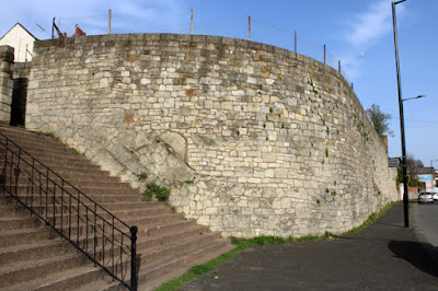
Firstly though, I had a quick look around the grounds, which is dominated by the Cholera Monument, built in 1835 to a triangular plan design by Michael Ellison Hadfield – a prominent Victorian Gothic Revival architect who was best known for his work on Roman Catholic churches, which include St. Marie’s Cathedral in Sheffield. 
 
The Cholera Monument

I didn’t take a close look at the massive grained sandstone used in its construction, but it lacks the uniform colour and texture seen in those from Stoke Hall, Bolton Woods and Crosland Hill, which are brought in from some considerable distance away in Derbyshire and West Yorkshire. 
 
The monument to John Blake

The grounds also include a large inscribed monument slab to John Blake, the Master Cutler who perished in the cholera epidemic in Sheffield in 1832, with 401 other victims, and a clay cobble art installation that was erected in 2004 and represents the individuals who lost their lives. 
 
A detail of the clay pebble mound art installation

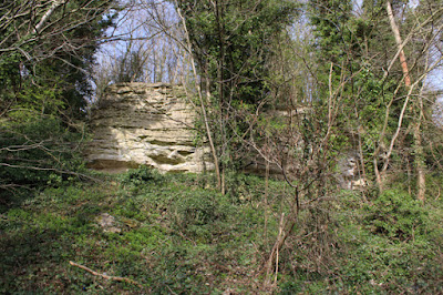
Eventually arriving at the heavily overgrown remaining face of Clay Wood Quarry, which is partly fenced off, I thought that I wouldn’t be able to get a look at the Silkstone Rock – whose only other location that I knew is in the cuttings at the northern approach to Sheffield Midland railway station. 
 
The access point to the Clay Wood Quarry

Slowly picking my way through hawthorne and brambles, whose spikes I took great care and time to avoid, I did manage to get close up to the barely visible rock exposures to take a few photos that show its irregular flaggy nature here. 
 
An exposure of irregularly bedded flaggy Silkstone Rock

The single sample that I obtained with my Estwing hammer is fine grained, light brown in colour and has noticeable iron staining in places, which often appear in outcrops as Liesegang rings – a characteristic of very many sandstones in South Yorkshire. 
 
Colour variation in the Silkstone Rock from Clay Wood Quarry

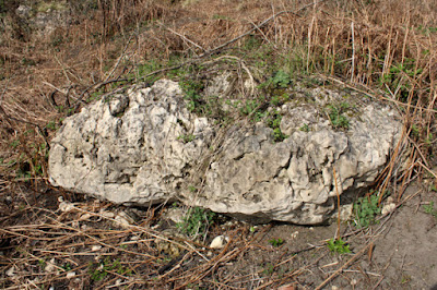
When looking around the area, I noticed that several large boulders of Pennine Coal Measures Group sandstone had been used for landscaping, but the boulder at the edge of the copse is partially embedded in the ground, which suggests that it could be from the Clay Wood Quarry. 
 
A boulder of sandstone at the edge of Clay Wood Quarry

Taking a quick look at the large boulders by the path, which I think have been brought in from further afield for landscaping, during the creation of the nearby South Street Park, I was interested to see that one contained numerous ironstone nodules. 
 
Ironstone nodules in a large sandstone boulder

The Silkstone Rock underlies a considerable part of central Sheffield, where it forms a plateau that overlooks the River Don and the River Sheaf, but around the Cholera Monument Grounds it forms a pronounced escarpment from which there is a panoramic view. 
 
A panoramic view from the Cholera Monument Grounds

Leaving the grounds on the way to have a look at the artwork that has been installed around Park Hill Flats, before catching my bus home, I had a very quick look at the stonework in a small group of Victorian terraced houses on Claywood Road.
 
Victorian terraced houses on Claywood Road

From the various stone buildings that I seen during the afternoon, as well as the extremely limited rock outcrop at Clay Wood Quarry, I would say that the stone was probably not obtained from the latter - with my educated guess being that it came from the old quarry in the Parkgate Rock, which has now been filled to form Skye Edge Fields.

A detail of masonry on Claywood Road
 

From City Road to Norfolk Road

 
A detail at the Victoria Methodist Church

Continuing down Granville Road, having had a quick look at the historic architecture and building stones along City Road, I first stopped at the entrance to Norfolk Heritage Park, where the walling for the lodge is built with what I think is Silkstone Rock, which was once extracted from a nearby quarry owned by the Duke of Norfolk. 
 
The lodge at the Granville Road entrance to Norfolk Heritage Park
 
The sandstone for the dressings and the crests carved on the lodge and the screen wall is a uniformly buff coloured medium grained sandstone. It looks very much like Stoke Hall stone from the Kinderscout Grit at Grindleford, in Derbyshire, which was used to build the old Sheffield Town Hall and for the dressings in many of the better quality Victorian buildings in Sheffield. 
 
A crest on the screen wall at Norfolk Heritage Park

Crossing over to the bottom of Stafford Road, I set off to investigate the tall church spire that I could see in the distance and came across further examples of crozzle on the old boundary wall on Ingram Road. Here, it alternates with blocks of squared sandstone to top an irregularly coursed and squared stone wall, where the greyish, fine grained sandstone has sporadic iron staining. 
 
Crozzle used for the topping of a stone wall on Ingram Road.

On the 1855 Ordnance Survey map, only half a dozen large houses had been built on the south side of Norfolk Road and Stafford Road was not yet in existence, with Gin Stables Lane being marked on the map; however, by the time of the 1906 edition, the area had been developed considerably and the use of crozzle seems to be a characteristic of this period - with further examples seen on the boundary wall to the Victorian Methodist Church and Sunday School, which was built in 1899. 
 
Crozzle on a boundary wall along Stafford Lane

Although partly obscured by C20 houses, which have been built in its former grounds on the frontage to Ingram Road, Gin Stables – now used as garages - still exist. From Stafford Lane, its upper section is seen to comprise well squared and coursed masonry that has a large proportion of orange/brown coloured blocks, with stone tiles used for the roof. 
 
Orange/brown sandstone used at Gin Stables

With so few accessible rock exposures or old quarry faces to examine, which voluntary groups such as the South Yorkshire RIGS Group and Sheffield Area Geology Trust have tried to identify and conserve, unless there is supporting documentary evidence, the determination of the provenance of any given stone usually requires an educated guess. 
 
Victoria Methodist Church

Approaching Victoria Methodist Church, although I have not yet discovered its architect, my first thought was that this might be another example of Crawshaw Sandstone – as specified by various architects who worked for the Sheffield School Board, whose work I had encountered in Crookes and Walkley - including that of WJ Hale. 
 
The main door to Victoria Methodist Church

With all of the quarries in Sheffield that supplied general building stone having long since closed, it is fortunate that the walling stone seen here and in many of Sheffield’s high quality buildings has proved to be very durable - as obtaining a good match for restoration work is not always very easy, which I discovered when working in the building restoration industry in London. 
 
The Triton Stone Library

The massive, uniformly buff coloured sandstone, which has been used for the dressings to the windows and doorways at Victoria Methodist Church looks like another example of Stoke Hall stone but, where it has been used for floriated capitals - in conjunction with pink Peterhead granite shafts – its pitted surface looks like the result of abrasive cleaning. 
 
A detail of a floriated capital at Victoria Methodist Church

Before returning to Norfolk Road, I had a quick look at the gate piers and boundary wall of the church, where there is a contrast in the condition of the best quality sandstone used for the caps, band courses and plinths and the local Parkgate Rock used for the basic walling.
  
A gate pier at Victoria Methodist Church
 
Noting the stonework in the boundary walls and the C19 houses, where I could see them, I then continued to the Shrewsbury Almshouses, where Silkstone Rock from the nearby Clay Wood Quarry was originally used, but refacing in the 1990’s was undertaken with Stoke Hall stone; however, with no public access available, I could only view these from a considerable distance.
 
The Shrewsbury Almshouses

Tuesday, 16 November 2021

A Walk Down City Road in Sheffield

 
A crozzle topping to a stone wall on City Road

My walk from Letwell to Maltby, at just under 10 km, had provided some good exercise, added to my knowledge of the Permian and Quaternary geology of Rotherham and enabled me to photograph more listed buildings for the British Listed Buildings website – as well as adding another mediaeval church to a growing list of those that I had visited in South Yorkshire.
 
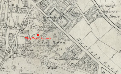
The 1855 Ordnance Survey Map of  Sheffield

Having had such a productive day, I could easily have taken it easy for a few days but, with the sun shining the next day, I decided to spend an afternoon in Sheffield – with my main objective to see if I could obtain a piece of Silkstone Rock from the old Clay Wood Quarry, which I had noticed on the Sheffield Area Geology Trust (SAGT) website.
 
To make a decent walk for myself, I decided to get off the bus at the main entrance of City Road Cemetery, which is set just below the escarpment of Parkgate Rock that forms the upper part of the cemetery and Skye Edge – a prominent topographic feature that overlooks Sheffield.
 
The gatehouse to City Road Cemetery

Getting off the bus, I could not help but notice the 'black granite’ memorials that were displayed outside K’s Memorials, which is located directly opposite the entrance to the cemetery. The designs were not to my taste, but I was very interested in the contrast in colour between the tooled and polished surfaces.
 
A 'black granite' memorial at K's Memorials

Crossing over the road to the Grade II Listed gatehouse, I didn’t have a close look at the sandstone used here and was more interested in the Crosland Hill stone, from the Rough Rock near Huddersfield, which has been used for a series of sculptures on City Road by Ben Leach, Tom Clark and Thomas Kenrick.
 
Sculptures at City Road Cemetery

Continuing down City Road, the stone wall at the entrance to the footpath to St. Aidan’s Rise caught my eye, with its top being adorned by large irregular lumps of a black material that looked remarkably like the vesicular basalt that I had seen on Mount Etna, as an undergraduate geologist more than 40 years ago.
 
A crozzle topped stone wall on City Road

This material is not basalt or any other kind of stone, but it is a slag that formed as a bi-product of the now obsolete process of making steel in a cementation furnace and is known in the Sheffield area as crozzle – a term also used for overcooked and blackened food, especially bacon.
 
A crozzle topping to a stone wall on City Road

Having my Estwing hammer with me, I chipped off a couple of pieces from a loose block and then carried on down City Road to look at the terraced houses, which I assumed had been built with stone from a local quarry in the Parkgate Rock. Although much of the masonry was blackened, a couple of recently cleaned houses showed the original colour and characteristics of this stone, which I hadn’t knowingly seen before.
 
Clean and dirty Parkgate Rock

After taking a few photos of the church of St. Aidan and St. Luke, I had a quick look at the  coarse gritty sandstone that has been used in its construction, which was quite unlike that seen in the local terraced housing and is probably one of the coarse sandstones from the lower part of the Pennine Lower Coal Measures Formation in the north-west part of Sheffield.
 
The church of St. Aidan and St. Luke

The dressings, however, looked much paler and very uniform in colour and, on close inspection, these proved not to be sandstone, but a textured artificial stone – a reflection of the development construction materials available when it was built in 1933.
 
A detail of artificial stone

Before turning down into Granville Road, I was interested to see the dilapidated H W Roberts Memorial Works next to Lyndhurst, where surprisingly its name appears not to be carved in sandstone but is another example of artificial stone. 
 
The former H W Roberts Memorial Works
 

Saturday, 13 November 2021

Geology and Architecture in Maltby

 
Maltby war memorial

The last leg of my walk from Letwell to Maltby, after my great disappointment at seeing the disgraceful state of Maltby Crags, started at the Grade II Listed Maltby war memorial, which is set off the main road 100 metres further to the north.
 
My walk from Letwell to Maltby

The memorial, unveiled in 1924, comprises a large plinth made of Carboniferous sandstone, upon which is set a pediment, cornice and finial capped by a crown, which are all made out of grey granite that comes from the Cornubian Batholith that underlies much of Devon and Cornwall in the south-west of England.
 
Maltby war memorial

Continuing down the hill towards Maltby, I was surprised to see that inferior quality Carboniferous sandstone has been used for parts of the boundary walling, instead of the pale grey Permian dolomitic limestone that is used ubiquitously in the area for building.
 
carboniferous sandstone used in a boundary wall

Stopping at the old Wesleyan Methodist Chapel, which has a distinctive orange stained sandstone used in the dressings of the front elevation the front elevation and polygonal sandstone rubble boundary walls, I made enquiries about the Maltby Local History Society who meet there. They had previously expressed an interest in the geology of the area and I wanted to inform them of the state of Maltby Crags.
 
The old Wesleyan Methodist Chapel

During my previous visit to Maltby, I had discovered that they held their meetings at the Wesley Centre but I was informed that all meetings has been cancelled due to the COVID-19 Pandemic and that my contact for them was unavailable. I was glad to have a rest and a chat here, especially since I was provided with a pint glass of ice cold water that was needed after a long walk.
 
Don John Steps
 
Continuing down to Don John Steps in the oldest part of Maltby, I had another look at the various outcrops of limestone that had been incorporated into the high retaining wall when the road to Blyth was widened in the 1920’s.
 
A retaining wall at Don John Steps
 
Having spent a good part of the day photographing historic buildings in Letwell and Firbeck to add to the British Listed Buildings website, as a part of its Photo Challenge, I continued this here by taking further photos of the mediaeval market cross.
 
The market cross

On High Street, the Grade II Listed mid-late C18 Kingwood View sits on the Magnesian Limestone escarpment, with its squared and coursed walling and pantiled roof providing good examples of the vernacular building materials in the area.
 
Kingwood View

Continuing westward along Rotherham Road towards the bus stop, I noticed that the boundary wall beneath the old Maltby Grammar School was permeated by a strong flow of water at the junction of the Permian Cadeby Formation and the underlying Pennine Upper Coal Measures Formation. This is adjacent to a now blocked up arch with the inscription “In Memory R.R. 1886”, which I think must have been a drinking fountain that tapped a spring here.
 
A memorial on Rotherham Road
 

Friday, 12 November 2021

Maltby Crags Revisited

 
A sample of Permian dolomitic limestone from Maltby Crags

Continuing my walk from Letwell to Maltby, I left Roche Abbey and headed west along the path that runs at the foot of the dolomitic limestone crags, where there are further examples of thick massive beds and solution cavities.
 
The crags to the west of Roche Abbey

With the crags disappearing from view behind the trees and undergrowth, I carried on until I reached the railway bridge, built of Staffordshire Blue bricks, which once served Maltby Main Colliery and was dismayed to see a group of teenagers, both boys and girls, with an empty shopping trolley that would no doubt end up being dumped somewhere.
 
A railway bridge made of Staffordshire Blue bricks.

Having seen many discarded ASDA shopping trolleys during various visits to Bowden Housteads Wood, I shook my head in disbelief at their mindless behaviour but, being in no position to say anything, I just carried on in silence.
 
Exposures of limestone along the track

Stopping only to note an old quarry face, which now forms the backdrop of an obscured private garden and a small outcrop of thinly bedded limestone on the track, after asking a couple of passers-by for the best route, I made my way up the hill to Maltby Crags.
 
A view of Maltby Crags in October 2015

When I last visited Maltby Crags a few years earlier, in early October, the area was largely covered in shoulder high bracken, which made access quite difficult and obscured very many of the smaller rock outcrops here.

A small outcrop of reef limestone

At one of the small outcrops that I could now see, I obtained a couple of small samples from a part where the unbedded mass of limestone has a very open sponge like texture, which were surprisingly difficult to remove with my Estwing brick hammer.
 
Samples of open textured reef limestone

I then went to find the principal Permian bryozoan reefs which, according to the JNCC (Joint Nature Conservation Committee) Geological Conservation Review entry for Wood Lee Common, are “the most accessible and amongst the best localities for the structure and fabric of typical bryozoan patch reefs in the Wetherby Member of the Cadeby Formation”.
 
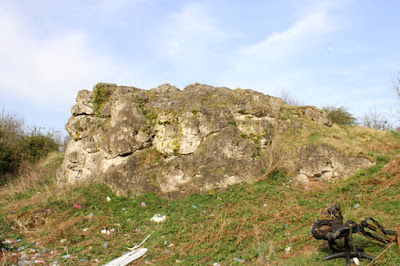
Permian bryozoan reefs at Maltby Crags
 
Designated as a geological SSSI (Site of Special Scientific Interest), large saccoliths have weathered out from the surrounding dolomitic limestone to leave tor like features - as described by the late Denys Smith, the British Geological Survey (BGS) field geologist who essentially defined the Marine Permian of England. 
 
Graffiti at Maltby Crags

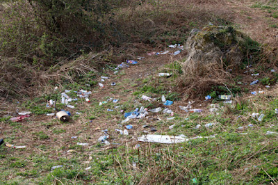
When approaching the lower reefs, to which I could now easily gain access, I was disgusted to see that one of the reefs had been daubed with extremely childish graffiti but, when further discovering that the area had turned into a rubbish tip, I then became incensed.
 
Rubbish at Maltby Crags

During my various walks since the beginning of the COVID-19 Pandemic, I had seen numerous examples of wanton disposal of miscellaneous rubbish along various paths and roadsides – from McDonald's or KFC containers thrown out of a car window to fully fledged fly tipping.
 
Rubbish at Maltby Crags

On this occasion, a burnt office chair, a catalytic converter and an ironing board were just the highlights amidst a great scattering of plastic bottles, cans and miscellaneous rubbish, which I am sure that the miscreant teenagers – probably high on whatever drug they could lay their hands on – wouldn’t even notice.
 
Rubbish at Maltby Crags

My efforts and achievements with the South Yorkshire RIGS (Regionally Important Geological Sites) Group, further work with the BGS and local museums have been quietly forgotten by SAGT (Sheffield Area Geology Trust) – an organisation that have appointed themselves to be the guardians of the geology of South Yorkshire – and Rotherham MBC, but I still retain a great interest in geological conservation in the region.
 
A site for fires at Maltby Crags

As I knew only too well, a group that comprises mainly long since retired university academics and school teachers – none of whom live in Rotherham – was in no position to report this and at the first opportunity I therefore e-mailed several individuals and organisations who I thought should be made aware of this.
 
A view of Maltby Crags

Most of the recipients of my e-mails didn’t bother to reply, but a single phone call to the head of planning at Rotherham MBC obviously made its mark, with e-mails immediately circulated to the officers concerned. The head of waste disposal actually phoned me to assure me that, once the Easter Bank Holiday had passed, a team would be sent immediately to clear up this mess - and to remove the graffiti - but I have not been back to Maltby Crags since to see if this has been done.
 
A detail of graffiti at Maltby Crags