 |
Maltby war memorial
|
The last leg of my walk from Letwell to Maltby, after my great disappointment at seeing the disgraceful state of Maltby Crags, started at the Grade II Listed Maltby war memorial, which is set off the main road 100 metres further to the north.
 |
My walk from Letwell to Maltby
|
The memorial, unveiled in 1924, comprises a large plinth made of Carboniferous sandstone, upon which is set a pediment, cornice and finial capped by a crown, which are all made out of grey granite that comes from the Cornubian Batholith that underlies much of Devon and Cornwall in the south-west of England.
 |
Maltby war memorial
|
Continuing down the hill towards Maltby, I was surprised to see that inferior quality Carboniferous sandstone has been used for parts of the boundary walling, instead of the pale grey Permian dolomitic limestone that is used ubiquitously in the area for building.
 |
carboniferous sandstone used in a boundary wall
|
Stopping at the old Wesleyan Methodist Chapel, which has a distinctive orange stained sandstone used in the dressings of the front elevation the front elevation and polygonal sandstone rubble boundary walls, I made enquiries about the Maltby Local History Society who meet there. They had previously expressed an interest in the geology of the area and I wanted to inform them of the state of Maltby Crags.
 |
The old Wesleyan Methodist Chapel
|
During my previous visit to Maltby, I had discovered that they held their meetings at the Wesley Centre but I was informed that all meetings has been cancelled due to the COVID-19 Pandemic and that my contact for them was unavailable. I was glad to have a rest and a chat here, especially since I was provided with a pint glass of ice cold water that was needed after a long walk.
 |
Don John Steps
|
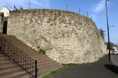
Continuing down to Don John Steps in the oldest part of Maltby, I had another look at the various outcrops of limestone that had been incorporated into the high retaining wall when the road to Blyth was widened in the 1920’s.
 |
A retaining wall at Don John Steps
|
 |
The market cross
|
On High Street, the Grade II Listed mid-late C18 Kingwood View sits on the Magnesian Limestone escarpment, with its squared and coursed walling and pantiled roof providing good examples of the vernacular building materials in the area.
 |
Kingwood View
|
Continuing westward along Rotherham Road towards the bus stop, I noticed that the boundary wall beneath the old Maltby Grammar School was permeated by a strong flow of water at the junction of the Permian Cadeby Formation and the underlying Pennine Upper Coal Measures Formation. This is adjacent to a now blocked up arch with the inscription “In Memory R.R. 1886”, which I think must have been a drinking fountain that tapped a spring here.
 |
A memorial on Rotherham Road
|
No comments:
Post a Comment