Saturday, 21 January 2023

Architecture in Broomhill & Endcliffe II

 
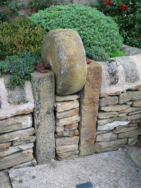
Walling stone at Endcliffe Edge

Continuing my exploration of the area around Broomhill and Endcliffe in Sheffield, with my primary objective to photograph various buildings for the British Listed Buildings website and to have a look at the building stones used in their construction, I made my way down Endcliffe Vale Road. 
 
A house that has been converted into two dwellings
 
In this affluent suburb, as with those on Fulwood Road, the houses are set back from the road in spacious gardens and very often screened by a high boundary wall, hedges and trees and I couldn’t really see very well the sandstone that they are built with, but the boundary walls seem to be mainly made of Crawshaw Sandstone, with other varieties used for gatepiers. 
 
Massive yellow sandstone used for a gate pier

The open character of the area of the C19, which was dominated by Endcliffe Hall (1865) – built for Sir John Brown by Flockton and Abbott – is now dominated by C20 housing and large blocks of student apartments owned by the University of Sheffield, but a series of lodges mark the entrances to large Victorian houses, some of which have since been demolished. 
 
An old lodge on Endcliffe Vale Road

These include the lodge to Endcliffe Hall, which is built in large blocks of uniformly buff ashlar sandstone that looks like it has been brought in from Derbyshire and is presumably the same stone that is used for the main house, which is now the Regimental Headquarters of Army Reserve unit 212 (Yorkshire) Field Hospital and is not accessible by the general public. 
 
The lodge to Endcliffe Hall

A little further along Endcliffe Vale Road, there is another lodge to Halifax Hall (1840), a house that was built for another Victorian steel baron, subsequently occupied as a university hall of residence for women and is now a hotel, wedding venue and conference centre. 
 
The lodge to Halifax Hall

Quickly walking down to Brocco Bank through detached and semi-detached villas, which formed part of the development of the area in the second half of the C19, I came across yet another lodge on Clarkehouse Road at the entrance to a house formerly known as Oaksholme, but which is now the Crewe Hall warden’s house at the University of Sheffield. 
 
The lodge to Oaksholme

The rapid expanse of the suburbs either side of Fulwood Road in the second half of the C19 entailed the construction of very many large houses, which would have required a considerable and regular output from the principal quarries supplying stone in Sheffield. 
 
A view of Saint Cecilia House
 
Although I was unable to closely examine the stone used in the many houses that I encountered between Taptonville Road and Saint Cecilia House (1865) on Westbourne Road - a distance of over 2 km - except for Endcliffe Hall lodge, I didn’t see any obvious differences in the colours and textures of the sandstone that I encountered.
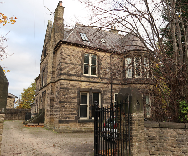
 
Another view of Saint Cecilia House

Mainly through my investigations of the Sheffield Board Schools, by now I had got to know the principal building stones used in Sheffield very well - using specialist stone identification skills first learned in the building restoration industry. I would therefore be very interested to see any documentation, which relates to the sourcing of stone used for the Victorian developments at the heart of the Broomhill and Endcliffe Conservation Areas.  

Broomhill and Endcliffe Conservation Areas

Friday, 20 January 2023

Architecture in Broomhill & Endcliffe I

 
Broomhill Community Library
 
My exploration of Ridgeway in the second week of November 2022 proved to be one of my more productive outings, having learned about its history of making edge tools and also acquiring a much better understanding of the structural geology of the area to the south of Sheffield. 
 
Listed buildings requiring photographs as at November 2021

A few days later on a sunny Saturday afternoon, which coincided with my birthday, I set off from Treeton to Sheffield, with a plan to photograph several listed buildings in the very attractive suburbs of Broomhill and Endcliffe for the British Listed Buildings website, before treating myself at Tuk Tuk Thai Street Food. 
 
9-17 Taptonville Road

Taking the No. 120 bus from High Street in Sheffield, I alighted at the Glossop Road/Ashgate Road bus stop and took a few photos of the terrace of brick built houses at 6-20 Ashgate Road (c1850), before moving on to Taptonville Road, where the three pairs of Grade II Listed semi-detached Classical style villas (c1855) – 9-11, 13-15 and 17-19 – are considered to be one of the highlights of the Broomhill Conservation Area. 
 
Broomhill and Endcliffe on the 1855 Ordnance Survey map

Many owners of the steel and cutlery businesses lived in or near to Broomhill and, spurred by the opening of the turnpike road to Manchester in 1821, a middle-class residential suburb with Classical and Gothic style villas developed in the 1830’s. None of the houses on Taptonville Road appear on the 1855 Ordnance Survey map, but development of the area to the north of Fulwood Road started in earnest from this time onwards.
 
Broomhill Community Library
 
Looking at the buildings from the pavement, and also the houses at No. 244 Fulwood Road and Broomhill Community Library, the sandstone is quite uniform in colour and, although containing some iron banding, the latter does not make any significant contribution to the overall colour and texture of the principal elevations. 
 
No. 244 Fulwood Road

Several quarries of varying sizes can be seen on the 1855 map, all of which are less than 2 km away, with the biggest quarries extracting the Crawshaw Sandstone at Crookes/Walkley and the Rough Rock on Lydgate Lane. 
 
None of these quarries still exist and exposures of these rock formations are few and far between in Sheffield and assigning a provenance to the sandstone is not easy; however, having seen the Crawshaw Sandstone in very many Sheffield Board Schools and the Rough Rock during my exploration of Crosspool and Fulwood, I would say that the former has been used for better quality houses, with the latter reserved for boundary walls and houses at the lower end of the market. 
 
The lodge to Endcliffe Crescent

Making my way down Fulwood Road, along which many of the above mentioned houses of the C19 industrialists are only visible from the top deck of a bus, I came across the lodge to Endcliffe Crescent - an estate development by the Endcliffe Building Company in 1824, which is the earliest example of ‘picturesque’ suburban development in Sheffield. 
 
The lodge to Tapton Cliffe

The sandstone used here is buff in colour with some iron staining, has planar bedding and is laid in thin courses – a feature that I have noticed is very common in the Crawshaw Sandstone – and this is seen again in the lodge to Tapton Cliffe, the house built in 1864 by the cutler John Yeomans Cowlishaw, and the boundary walls on Shore Lane.
 
Crawshaw Sandstone used for boundary walling on Shore Lane

Continuing along Fulwood Road past more large detached and semi-detached houses, which are set in substantial grounds that overlook the Porter Valley, I came to yet another lodge (c1850) – this time at Oakbrook, the house built by the industrialist and philanthropist Mark Firth. 
 
The lodge to Oakbrook
 
The general colour, planar bedding and relatively thin courses of stone suggest that this is a further example use of the Crawshaw Sandstone, with pink Peterhead granite used for colonnettes on the windows - a material that I didn't expect to see here.
 
A Peterhead granite colonnette
 

Monday, 16 January 2023

Geology & Architecture in Ridgeway V

 
A topographic map of the Moss Valley

Leaving Birley Hay by the public footpath that runs north from Geer Lane, to continue my exploration of the geology and architecture of Ridgeway, my knowledge of the area was further improved when - having later consulted my geological memoir - I learned that this runs up the dip slope of an unnamed Pennine Lower Coal Measures Formation (PLCMF) sandstone on the southern limb of the Norton-Ridgeway Anticline. 
 
Arriving at the old hamlet of Litfield, which is now incorporated into the larger settlement of Ridgeway, I first encountered The Grange - a converted agricultural building that is marked on the old Ordnance Survey maps as being part of Litfield Farm. 
 
The Grange

Litfield Farmhouse, which was built in the early C17 and extended in the C18, is closely associated with the Staniforth family – including those members who contributed to the local edge tool manufacturing industry as shearsmiths. 
 
Views of Litfield Farmhouse
 
The house is set back from the main road and, as I had discovered when supplying very many photos for the British Listed Buildings website, high boundary walls prevented me from getting close enough to photograph it properly and I had to settle for a few glimpses from various viewpoints and angles.
 
The remains of an old farm building

Although I couldn’t get close enough to take a good look at the sandstone used at Litfield Farmhouse, The Grange is built in a light brown sandstone that contains a fair proportion of rusty brown blocks and, on the opposite of the road, the remains of an old farm building is built in iron stained flaggy sandstone. 
 
A view on the public footpath from Doe Lane to Sloade Lane

When preparing a walk, I usually have a good look at the online Geology of Britain Viewer, or my printed 1:50,000 map, to get an idea of the underlying geology, but I never cease to be amazed by the topography that I encounter where sandstones alternate with the softer siltstones and mudstones. Walking from Doe Lane to Sloade Lane, the path drops down into a notable valley - along which an intermittent stream flows - before rising up onto the Grenoside Sandstone. 
 
A bridge across an intermittent stream

I stopped briefly to look at the elegant Cromwell House, which is described in the Ridgeway Village History website as being built in the Regency period. Looking at the yellowish sandstone used for the well squared and coursed masonry, which has a batted finish, I suspect that this is Grenoside Sandstone from the nearby Lumb Wood quarry. 
 
Cromwell House

Walking down Sloade Lane, I passed a few converted agricultural buildings built in a sandstone that is yellow in colour and contains a proportion of iron rich rusty brown blocks, which makes me think that the Grenoside Sandstone was selected for the better quality buildings and an unnamed PLCMF sandstone has been used for the farm buildings. 
 
Various converted farm buildings on Sloade Lane

Finally reaching the early C17 Dowland Farmhouse, a high boundary wall again made it very difficult to get good photographs of the building and I just took a few quick snaps from the open gateway and a much better photo of a stone acorn that adorns a gate pier. 
 
A stone acorn at Dowland Farmhouse

Continuing down Sloade Lane, which here approximately follows the plunging fold axis of the Norton-Ridgeway Anticline, I was interested to see the ford that crosses Robin Brook – the first that I can remember seeing since living in South Yorkshire. 
 
The ford on Sloade Lane

Crossing over the ford on the elevated footpath, I looked down over the railing on the downstream side to see the brook dropping down to an exposure of thinly bedded sandstone/siltstone in the streambed, with overlying highly laminated mudstone exposed in the stream bank. 
 
Siltstone and mudstone in Robin Brook

Returning to the public footpath that I had passed when walking down Sloade Lane, I crossed over Robin Brook and continued over a narrow flood plain before climbing up a steep set of steps to Church Lane and, after reaching Main Road, the No. 252 bus back to Sheffield came into view before I could think about having a quick pint in Ridgeway at the end of a very good walk.
 
The steps from Robin Brook to Church Lane


Sunday, 15 January 2023

Geology & Architecture in Ridgeway IV

 
A streambed exposure of sandstone in Birley Hay

Continuing my investigation of the geology and historic architecture of Ridgeway, I headed down Ridgeway Moor and stopped very briefly to photograph the pebbledashed Oak House for the British Listed Buildings website, before arriving in the hamlet of Ford. 
 
Various historic buildings in Ford

As a general record of one of the hamlets that were part of the renowned scythe and sickle manufacturing industry in the area, I took a few photographs of the various buildings – built in the same mixture of sandstones that I had encountered on my walk so far - and went to have a quick look at the Ford Wheel Dam. 
 
Ford Wheel Dam

I didn’t see anything that caught my interest as a geologist but, having already considered the possibility of following the Moss on a walk from Jordanthorpe to Eckington, I made a mental note to do this in the near future – especially since I would like to have another look at the grindstones, which it has been suggested may come from Rotherham. 
 
A grindstone at the Bridge Inn

Following Ridgeway Moor to the west, I soon came to another complex of agricultural buildings at Ford Farm, where I took a few photographs of the Grade II Listed Ford Farmhouse (c1750) and some of its C18 outbuildings, which are built in a sandstone that is similar to that used for other buildings seen in Ford. 
 
Ford Farmhouse and an outbuilding

Continuing along Geer Lane, I was interested to see the distinct escarpment formed by a minor unnamed Pennine Lower Coal Measures Formation (PLCMF) sandstone which, being on the southern limb of the Norton-Ridgeway Anticline dips to the south. 
 
A sandstone escarpment at Geer Lane

Arriving in Birley Hay, a small industrial hamlet that had a scythe and sickle works that used water power for the grinding, I made my way up a public footpath at the foot of the escarpment in search of the Grade II Listed Birley Hay Farmhouse, dating to the early C17, and an outbuilding of the same age. Following the path down to the crossing of a tributary to the Moss, I noted that nearly horizontally bedded flaggy sandstone was exposed in the streambed. 
 
A streambed exposure of PLCMF sandstone

Continuing along the footpath on the west side of the stream, I could only take a few general photographs of these buildings at a distance, but from these I am able to see that there is no change in the sandstone used in their construction, with it containing colour variations from yellowish to rusty brown. 
 
Birley Hay Farmhouse and an outbuilding
 
Retracing my steps to the escarpment overlooking Birley Hay and carrying on down the path to Geer Lane, I had a quick walk around the hamlet to take a few record photographs of the various cottages and make a mental note of the materials used. 
 
Various historic buildings in Birley Hay

I didn’t get to see the old warehouse, which is the last remnant of the scythe and sickle works, as it is on a private road but I did manage to photograph the Grade II Listed No. 8 Birley Hay, which is late C18 in date and provides another example of the local sandstone. 
 
No. 8 Birley Hay

Having briefly explored the parts of Birley Hay that were readily accessible, I set off on my journey back to Ridgeway via a public footpath that would take me to Litfield Farmhouse and Dowland Farmhouse. Walking up the dip slope of an unnamed PLCMF sandstone on the southern limb of the Norton-Ridgeway Anticline, I stopped to look back at the landscape to the south-west. 
 
A panoramic view across the Povey Syncline

The anticline has a considerable fault at its southern edge, with the Povey Syncline – along which the Moss flows – being succeeded further to the south by the Troway Anticline, which forms the high ground in the distance. 
 

Wednesday, 11 January 2023

Geology & Architecture in Ridgeway III

 
A sample of sandstone collected at Ridgeway Moor

Leaving the Church of St. John the Evangelist and continuing down Main Road, I stopped briefly to take a quick look at another example of dry stone walling, where light brown, cross-bedded, massive sandstone - with dark brown concentrations of iron oxides/hydroxides on the joints - has been used in conjunction with thin flaggy beds. 
 
Massive and flaggy stone used in a dry stone boundary wall

A little further along the road, where its name has changed to Ridgeway Moor, the now disused Ridgeway Methodist Chapel (1806) was the next building to photograph for the British Listed Buildings website and, as with the various other historic buildings that I had so far seen in Ridgeway, I didn’t closely study the stonework. 
 
Ridgeway Methodist Church

Looking at the junction between the chapel and the porch (1901), however, there is a noticeable difference between the colour of the sandstones, with the latter being noticeably yellow with some orange variation, where weathering has removed the patina. As with No. 86 Main Street, where the sandstone is also yellow, I have made the assumption that this is the Grenoside Sandstone that was once worked from the Lumb Wood quarry
 
Walling of the porch to Ridgeway Methodist Church
 
At the adjacent Stubbin Hill Farm, the walling stone used for the converted agricultural building facing the road has a high proportion of dark rusty brown blocks, which reflects the very high iron content of the strata in this section of the Pennine Lower Coal Measures Formation (PLCMF). At nearby Eckington, in particular, the ironstone beds and coal had considerable economic value and was notably exploited by the ironmaster George Sitwell, who built Renishaw Hall. 
 
A converted building at Stubbin Hill Farm

On the other side of the entrance from Ridgeway Moor, which by now had developed quite a marked slope, I stopped to take a good look at a field boundary wall, where its very irregular undulating form reminds me of gently folded beds of flaggy sandstone. 
 
A boundary wall built on foundations of sandstone bedrock

I was interested to see that it has been built directly onto bedrock, comprising a buff/yellow thinly bedded sandstone that is quite obviously the same as that used for the walling stone. Although I didn’t think about it at the time, the sandstone has an apparent dip that follows the slope of Ridgeway Moor to the south. 
 
An exposure of PLCMF sandstone beneath a dry stone boundary wall
 
When later looking at the 1:50,000 geological map and the accompanying memoir, I realised that I had by now crossed a plunging fold known as the Norton-Ridgeway Anticline – one of a series of WNW-ESE trending anticlines and synclines that, continuing to the south, also includes the Povey Syncline, the Troway Anticline, the Dronfield Syncline and the Brimington Anticline. 
 
The sample of the unnamed PLCMF laminated sandstone, which I prised out with my fingers and a steel knife, is muddy light brown in colour, very fine grained and contains very small amounts of mica and coal, with accumulations of iron oxides/hydroxides on bedding planes and concentrations on the joint plane. 
 
A sample of sandstone from Ridgeway Moor (21 mm diameter coin)

At the junction of Ridgeway Moor and Sloade Lane, the fall of the land down to The Moss, which runs along the fold axis of the Povey Syncline, and its rise to the south of this watercourse clearly shows the structure of the rocks, although no outcrops could be seen. 
 
A view across the Povey Syncline from Ridgeway Moor

On the opposite side of the road, the late C18 Grade II Listed outbuilding was once an edge tool workshop and Commonside Farm, of which this building forms a part, is referred to as the “Commonside Manufactury (Sickle)” on the 1882 edition of the Ordnance Survey map. The sandstone used in the building, now called Sickle Cottage, is generally buff to light brown in colour and contains a considerable proportion of dark rusty brown blocks. 
 
The former sickle making workshop at Commonside Farm

The unlisted Scythe House, another converted workshop on the opposite side of the entrance to Commonside Farm, is built in a sandstone that is generally much paler in colour and is more like the walling stone seen at Ridgeway House and Thornhill. 
 
Scythe House

A reminder of its industrial history can be seen in the dry stone garden boundary wall fronting Ridgeway Moor, where an old grindstone has been incorporated into an ornamental feature that surrounds a drain cover in the pavement. 
 
An old grindstone used as a garden feature

I stopped briefly to look at the boundary wall immediately to the south of Scythe House, where the greyish patina has been weathered away and the sandstone deeply scoured to reveal a generally yellow/pale orange coloured cross-bedded sandstone. As previously noted in the inconsistent patterns of colour and texture in the stonework of the various historic buildings of Ridgeway, this again suggests that a number of quarries on different rock formations in the immediate area supplied the stone.
 
Sandstone in a boundary wall to the south of Scythe House