Monday, 15 May 2023

Geology at Crystal Palace Park

 
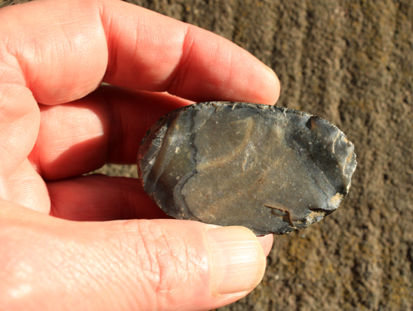
A broken flint pebble from Crystal Palace Park

Following on from my investigation of the geology and historic architecture in and around Wadsley Park Village, my next trips coincided with a week spent in London – to help my 92 year old mum after she had come out of hospital, having fallen over and broken her hip when scarifying the lawn. 
 
Crystal Palace Park
 
Having completed essential tasks such as mowing the lawn, watering various plants, clearing up fallen blossoms, moving potential trip hazards and doing the shopping - while at the same time photographing various listed buildings around West Wickham for the British Listed Buildings website – I set out to explore Crystal Palace Park, with the intention of visiting its ‘dinosaurs’. 
 
The 1921 geological memoir for South London describes the Crystal Palace ridge, along with isolated plateaux of Richmond Park and Wimbledon Common, as being amongst the principal topographic features. Standing at a height of 110 metres above sea level, this high point is now emphasised by the Crystal Palace transmitter, which can be seen from miles around. 
 
This high ground in the Tertiary strata is formed by the Claygate Member, the sandy upper part of the London Clay Formation, which differs considerably from the lower part - a heavy, blue/grey homogenous clay that I remember from digging trenches for foundations in north London, when working as a builder’s labourer before studying geology at Nottingham University. 
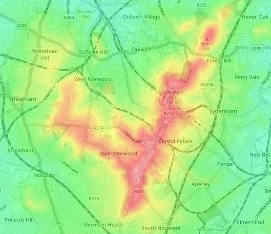
 
A topographic map of the Crystal Palace ridge

Growing up in South London, I clearly recall the topography formed by the various river terraces that drop down from Clapham Common and the steep slope that rises up to Upper Norwood but, apart from my brief exploration of Wimbledon Common the year before, I had never given much consideration to London’s geology. 
 
A walkway cover in flint pebbles

Having had a quick look at the various terraces, which are the remains of the Crystal Palace that burned down in 1936 and will be described later, I was very interested to discover that the various walkways are covered in gravel that is composed largely of various sized pebbles of black flint. 
 
The geology around Crystal Palace Park

I later learned that the highest part of the Crystal Palace ridge is covered by Quaternary gravel of an unknown age which, according to the geological memoir, consists mainly of Chalk flints, with a large proportion of Tertiary pebbles and Greensand chert, which are derived from the south and probably represent the outwash from snow or ice covered ground that was beyond the limits of the Pleistocene ice sheet. 
 
Flint pebbles from Crystal Palace Park (21 mm diameter coin)

Having picked up a few pebbles to add  to my rock collection, I then made my way down to the Information Centre, where I came across a large boulder of Precambrian Lewisian gneiss – one of the ‘Millennium Rocks’ from the coastal village of Lochinver in north-west Scotland, which were given to the borough of Bromley in 2000. 
 
A boulder of Lewisian gneiss
 
Although this rock is obviously not an example of the local geology, every student of geology in the UK is taught about the Lewisian gneiss in the north-west of Scotland – which very few will ever visit – and it was therefore a very pleasant surprise to discover this.
 
A detail of the Lewisian gneiss

Thursday, 11 May 2023

A Walk from Upperthorpe to Broomhall

 
A detail of St. Mark's Church Mission Room

After my brief investigation of the former Sheffield Royal Infirmary, I took a few photos of various Grade II Listed brick built early Victorian houses on Upperthorpe Road and made my way up through the Ponderosa to the corner of Mushroom Lane and Winter Street. 
 
A gatepier at Weston Park
 
Here there is a large complex of substantial brick buildings at St. Georges Hospital (1882), part of which is occupied the Department of Law at Sheffield University. I just took a few record photos and continued to the bottom entrance to Weston Park, where massive gritstone has been used for gatepiers and planar bedded sandstone for the walling – which I presume to be further examples of Chatsworth Grit and Crawshaw Sandstone respectively.
 
A detail of walling and a gatepier at Weston Park

Continuing up through Weston Park, I stopped briefly to take a few photographs of the entrance portico to the Grade II* Listed Mappin Art Gallery (1887), by Edward Mitchel Gibbs of Flockton and Gibbs, which is now part of Weston Park Museum. 
 
The portico at the Mappin Art Gallery
 
The building is made of uniformly coloured buff/light brown medium grained massive sandstone, which is probably from the Millstone Grit Group of Derbyshire or West Yorkshire. It is very suitable for fine carving, as can be seen in the details of the pediment, which incudes the Sheffield crest, floral decoration and what appears to be artist’s palettes with paintbrushes. 
 
A detail of the pediment at the Mappin Art Gallery

I then made my way down past various hospital and university buildings down to Claremont Place, where I photographed the early Victorian, brick built Nos.8 and 10 and then the old Baptist Church (1871) on Glossop Road, which has a Sunday School (1886) by C.J. Innocent – who was best known for his designs of the early Sheffield Board Schools. 
 
The former Baptist church on Glossop Road
 
Continuing down Brunswick Street, the unlisted St. Mark’s Church Mission Room (1905) provides another example of uniformly buff coloured Crawshaw Sandstone, with its distinctive planar bedding and relatively thin courses. 
 
St. Mark’s Church Mission Room
 
A little further down Brunswick Street, at the corner of Collegiate Crescent, is one of the former lodges to the Broomhall Estate - parts of which I had investigated the previous year and, although I didn’t inspect the stone, it looks more massive than the Crawshaw Sandstone. 
 
A former lodge to the Broomhall Estate
 
The last buildings on my list to photograph were Nos. 2-4 and 6-8 Collegiate Crescent, two pairs of semi-detached houses that were built c1845 with grey to orange coloured ashlar sandstone and massive sandstone dressings. 
 
Nos. 2-8 Collegiate Crescent

Having photographed all of the buildings on my list, I then made my way back towards Sheffield City Centre via Winter Street, where I was interested to see that the Eyewitness Works were being refurbished and, after picking up some more shopping on The Moor, I finished a good long walk with a pint of stout at the Old Queen's Head.
 
A pint of stout at the Queen's Head
 

Tuesday, 9 May 2023

Infirmary Road and the Heritage Park

 
The Heritage Park

My 3.5 kilometre walk around Wadsley Park Village, which ended back at the Middlewood Park and Ride, had only taken an hour and a half and, with it only being 12:30 in the afternoon, I caught the Supertram to the Infirmary Road stop.
 
My walk from Infirmary Road to Sheffield

My plan was to take some more photographs for the British Listed Buildings website around Upperthorpe, Broomhill and Broomhall and then walk back into Sheffield city centre but, having taken advantage of the Tesco Superstore to buy a few essential items, I started by taking a look at the buildings that formed part of the Royal Infirmary. 
 
The 1855 Ordnance Survey map showing the Royal Infirmary

The Historic England description of the infirmary, now Heritage House, states that it was completed in 1797 to a design by John Rawsthorne and this is marked quite clearly on the 1855 Ordnance Survey map, along with a lodge at the north-east corner of the site. 
 
The former lodge to the Royal Infirmary

A few years previously, I had taken a few photographs of the lodge on one of my occasional visits to this part of Sheffield, which I thought might be built with Chatsworth Grit; however, since reading the short article on the Sheffield Area Geology Trust (SAGT) website, which records investigations into the provenance of the sandstone used to build the Royal Infirmary – it seems very likely that this is Loxley Edge Rock from quarries along Loxley Edge. 
 
A detail of the stonework at the former lodge

Since starting my investigations of the Victorian Sheffield Board Schools back in February 2021, I have been to very many parts of Sheffield to photograph various listed buildings for the British Listed Buildings website – including Malin Bridge and Wadsley, where the local Loxley Edge Rock has obviously been used for many of these. 
 
A detail of the stonework at the former lodge

I have briefly visited Loxley Edge on three occasions and have collected various samples of this rock with my Estwing hammer and, although it seems to lack the small pebbles that are very common in the Chatsworth Grit, it can be a very coarse gritstone. 
 
A view along the front of the south-east elevation

Looking along the south-eastern elevation of the block, although not see in the best light, the sandstone would be described as wild, with orange and sometimes rusty brown iron blotches and Liesegang rings contrasting strongly with the generally drab grey colour of the body of the stone.
 
A view of the front of the north-east elevation

Access and views are quite limited on this elevation and I took only a few record photographs, before moving round to the front elevation, where the same colour variation could be quite clearly seen on an unlit surface. 
 
A geological map of north-west Sheffield

It is only 4.5 km as the crow flies from the old quarries mentioned at Loxley Edge by SAGT, with a direct route down Dykes Hall Road and through Hillsborough and, from what I have seen of the Loxley Edge Rock - in outcrops and in vernacular architecture and boundary walls - I have no reason to think that these are not the quarry source. 
 
Views of the Heritage Park

The Heritage Park is a private residential development so I just took a few  photos of the principal elevations, without getting close to look at the stone. When the sun came out, the grey nature of the sandstone is not so obvious, but again becomes very noticeable when in the shade. 
 
The rear entrance to the south-east block

I had a quick walk around the exterior of the Roundhouse (1884), the former Outpatients' department, which is by John Dodsley Webster. Looking at the walling stone, it is obvious that it is not the Loxley Edge Rock, with its relatively uniform colour, thin courses and planar bedding. I immediately thought that this must be Crawshaw Sandstone, with Derbyshire or Huddersfield stone used for the dressings. 
 
The Roundhouse

The last remaining part of the Royal Infirmary is Centenary House (1897), which is also by John Dodsley Webster and was formerly the Nurses' home. I only took a few general photos from a distance, but it again is built with a uniformly buff bedded sandstone that looks very similar to the Crawshaw Sandstone that has been used for the Sheffield Board Schools – again with Derbyshire or Huddersfield stone dressings.
 
Centenary House

Monday, 8 May 2023

An Exploration of Wadsley Park Village

 
A tree stump at Wadsley Fossil Forest (2003)

Leaving The Quarry, I continued up Middlewood Road until I reached the former porter’s lodge (1877) of the South Yorkshire Asylum, which was probably designed by Bernard Hartley – the West Riding of Yorkshire surveyor who was responsible for the Middlewood Hospital (1871). 
 
A detail of the lodge

I just took a few photos of this Grade II Listed building for the British Listed Buildings website and then continued into the new estate until I reached the Middlewood Hospital church (1875), which was also probably designed by Hartley - according to the Historic England description. 
 
The Middlewood Hospital church

The church has been disused for more than 25 years, with various plans to convert it into apartments being unsuccessfully submitted to Sheffield City Council. At the time of my visit, the windows were boarded up and it could only be seen from a distance through heras fencing.
 
A detail of masonry to the apse of the church

The stonework was moderately dirty and I couldn’t get much of an idea about its physical characteristics; however, looking at my photographs, the massive sandstone used here has grey to orange/brown colouration that is consistent with the Loxley Edge Rock, which was extensively quarried at Wadsley Common and on the lower slopes to the east of Worrall. 
 
Middlewood Lodge

I then went to have a look at Middlewood Lodge, a gated development of 38 apartments that has been converted from the original administration block. From a distance, the sandstone used for dressings looks uniform in colour and, as seen at the lodge, is probably Derbyshire gritstone. 
 
Sandstone dressings at the main entrance to Middlewood Lodge
 
The next stop on my walk was the replica fossil tree stump, installed with an interpretation panel in 2018, which marks the site of Wadsley Fossil Forest. This was cast from a mould of one of several stumps that were discovered in 1872, when land was being levelled before the hospital was built.  
 
The replica tree stump and interpretation board

As the Chairman of the barely functioning South Yorkshire RIGS (Regionally Important Geological Sites) Group, I had seen one of the original stumps back in 2003, when members of the Sorby Natural History Society, who had volunteered to do the clearance, were invited to attend a talk by Duncan McLean - then at Sheffield University - before they were buried.
 
Duncan McLean and members of the Sorby Natural History Society

When originally uncovered, the eminent Sheffield geologist, Henry Clifton Sorby, was informed of the discovery and it was largely down to his efforts that the importance of these was recognised. Although very many Carboniferous tree stumps have been found in the UK - including the one seen at Sheffield Botanical Gardens - it is very rare to encounter several stumps in one place and Henry Sorby arranged for sheds to be built, to provide shelter and to allow visitors to see them.
 
Continuing my walk, I then photographed the Grade II Listed former Kingsway Ward (1878), which is now the Kingsway Hall apartments. It is again brick built with massive sandstone dressings but, looking at the latter from a distance, it does not appear to use the same stone that can be seen in the lodge and the administration block.
 
The former Kingsway Ward

Moving closer to get a better look at the arch to the main entrance and other high level details, the sandstone is distinctly yellow in colour, which is typical of the Grenoside Sandstone seen at Grenoside and Birley Carr and not Derbyshire gritstone. 
 
The datestone at the Kingsway Ward
 
Making my way down towards Middlewood Road by the public footpath, I stopped briefly to look at the view of the escarpment of the Greenmoor Rock, which forms Birley Edge and continues south through Sheffield - where it is seen in several prominent landforms.
 
A panoramic view of Birley Edge

Arriving at Middlewood Road, I took a few quick snaps of the
very coarse grained sandstone used for the boundary walls and the terraced houses, where the grey to orange/brown colouration seen beneath the dirt suggests that this is another example of locally quarried Loxley Edge Rock. 
 
An entrance to Wadsley Park Village

Sunday, 7 May 2023

The Quarry on Middlewood Road

 
A sample from The Quarry

When visiting Loxley Edge and Wadsley Common, where I was shown around by a resident Jan, we had a quick discussion about the stone used to build her house, which did not look like that used for the houses in Wadsley, when it was suggested that it may have come from the demolition of buildings at the nearby Middlewood psychiatric hospital. 
 
An old quarry marked on the 1855 Ordnance Survey map

For my next walk, after my exploration of the Towers, Sandygate Road, Stumperlowe and Fulwood Road, I decided to explore the area around Wadsley Park Village, a housing development that has been built on the site of the asylum grounds – starting at an area of land named as The Quarry on Google Maps, which is marked as a sandstone quarry on the 1855 Ordnance Survey map. 
 
The 1906 Ordnance Survey and LIDAR maps

On the 1906 edition, this is marked as the site of the Klondyke Brickworks, which closed in 1936 after a few changes of ownership but has surprisingly remained undeveloped. The LIDAR map shows a substantial quarry face and, having taken the Supertram from Sheffield city centre to Middlewood Park and Ride, I went to investigate. 
 
A view towards the old quarry face
 
Looking at the 1:50,000 British Geological Survey map, the brickworks is sited on the Pennine Lower Coal Measures Formation beneath the Loxley Edge Rock, which is downthrown to the east of the Sheffield Fault. According to the geological memoir, the lower part of the Loxley Edge Rock largely comprises shale and mudstone, which was exploited to make the bricks here. 
 
The geology around Middlewood

Moving closer to the exposed quarry face, I could only see sections of alternating beds of fine grained sandstone, siltstone and mudstone, which look nothing like the coarse grained Loxley Edge Rock that I had seen during my previous investigations of Sheffield’s geology. 
 
A view of the old quarry face

Making my way through the undergrowth, which so often obscures old quarry faces, I zoomed in with my Canon G7X Mark II Powershot camera to a section where ripple marks can be clearly seen in the finer grained beds. 
 
A detail of the old quarry face
 
Continuing along the quarry face, I noted further sections where thin flaggy beds in the generally cross-bedded sequence pass downwards into siltstone and much finer grained sediments, which are clearly seen from their differential weathering.
 
Siltstone and mudstone exposed in the old quarry face

I couldn’t safely get to the quarry face to retrieve a sample with my Estwing hammer, but I was able to collect a sample of very fine grained, cross-laminated brown sandstone, which contains no mica but has specks of carbonaceous material on the bedding plane.
 
A sample from The Quarry