Monday, 16 August 2021

Bowden Housteads Wood Revisited

 
Spheroidal weathering in Bowden Housteads Wood

After seeing the Carr Brook disappear into the culvert in the south-west part of Bowden Housteads Wood, I crossed over the A57 and, passing Parkway Man, I followed the path over the footbridge on the Sheffield Parkway.

Parkway Man

During my previous walk to look at the geology in the northern sector of Bowden Housteads Wood, I had followed a tributary of the Carr Brook but, on this occasion, I took the path that runs clockwise around Parkway Fire Station.
 
A Google Map view of Bowden Housteads Wood

Finding a steep sided valley where I couldn’t get down to the stream bank, I followed the path along the course of the Carr Brook without seeing any rock outcrops. Arriving at the confluence with this upper tributary, I then went in search of another lower tributary, where I had found a dry streambed with the bedding plane of a flaggy sandstone exposed.
 
A tributary of the Carr Brook
 
I didn’t find this particular exposure but, with the thick undergrowth having died back, I was able to get close to the bank of the stream and followed its course for a few hundred metres - across various Pennine Middle Coal Measures Formation (PMCMF) rocks - until it disappeared into a culvert beneath the Sheffield Parkway.
 
Bowden Housteads Wood

As with my walk along Shirtcliff Brook a couple of weeks earlier, I encountered stream bank sections of black topsoil overlying mudstone, which is weathered to yellow clay, and various unweathered mudstones and siltstones.
 
Yellow clay in the stream bank
 
A little further upstream, in places the stream channel is not well defined and widens out into muddy pools, where accumulations of dead leaves are mixed up with layers of silt that have spread out over them in times of flood.
 
An accumulation of dead leaves and silt

Although I wasn’t able to establish their precise position in the landscape without GPS, the geological map of the area shows that I crossed two minor PMCMF sandstone bodies, which were formed in swamps, estuaries and deltas.
 
Bedding planes exposed in the streambed

In several places, the bedding planes of flaggy sandstone/siltstone are exposed in the streambed, with individual beds occasionally up to 150 mm thick, but generally these do not develop into massive sandstone and frequently pass into fine siltstone and mudstone.
 
Siltstone and mudstone in the stream bank
 
During this walk and other investigations of streams on the PMCMF strata in South Yorkshire, I had encountered numerous examples of yellow clay in the stream banks and, having resumed following the stream in Bowden Housteads Wood, after it had passed beneath a path in a culvert, another yellow coloured rock caught my eye.
 
Yellow sandstone in the stream bank

Exposed over a length of just a few metres, the typical siltstone/mudstone in the stream bank passes upwards into a more massive sandstone that exhibits spheroidal weathering, with the dark body of the sandstone changing to a marked yellow colour.
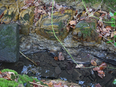
 
Yellow sandstone above mudstone and siltstone

I had never seen anything like this before and I wished that I had a geological hammer and a pair of wellingtons with me, so that I could get down into the stream bank and further investigate – especially since, in places, this bed appears to pass laterally and vertically into yellow/grey clay.
 
Weathered mudstone above siltstone

Sunday, 15 August 2021

An Exploration of the Carr Brook - Part 2

 
A sample of sandstone from Bowden Housteads Wood

Arriving at Hastilar Road South, having followed the course of the Carr Brook from its headwater and then taken a diversion to the church of St. Theresa, I continued downstream through Carbrook Ravine Nature Reserve but I didn’t seen any rock outcrops.
 
A view west down the escarpment to the Carr Brook

The east side of the brook is bounded by an escarpment of Pennine Middle Coal Measures Formation (PMCMF) sandstone, which I explored briefly before returning to the path that runs alongside the brook and then stopping at what I thought was an old mill pond; however, I have since discovered that this first appeared on the 1939 Ordnance Survey map as a swimming pool.
 
The old swimming pool
 
On my visit the previous summer, I turned right here and followed the path up a moderately steep slope where there were occasional patches of subsoil/bedrock exposed in a few eroded places on the path. This time, I carried on to investigate a small streamlet that appeared to form part of some kind of landscaping feature above the west side of the Carr Brook valley.
 
A streamlet and rock feature

Continuing past a pile of sandstone blocks, which I thought might mark the head of a spring, the streamlet continued up to a large shallow pond, which was frozen over at the time. At the far end of this, another large pile of bigger sandstone blocks caught my eye, which I then went to investigate.
 
A view of the pond on Manor Playing Fields

It is on the edge of an area that the LIDAR map shows as Manor Playing Fields, which has been obviously landscaped into wide terraces, but there is no sign of any natural drainage channel leading to the Carr Brook here.
 
Rocky landscaping at Manor Playing Fields

I didn’t stay around to examine any of the Coal Measures sandstone blocks used in its construction, but I thought that it was an interesting piece of landscaping and it reminded me of places like Padley Gorge and Wyming Brook – where large blocks of stone have tumbled down the head of the valley.
 
A view east towards the Carr Brook

Making my way back down to the Carr Brook, and following the very muddy path that runs alongside its west bank, I was dismayed to see that the streambed was littered with shopping trolleys, various bikes and miscellaneous other items of rubbish.
 
Miscellaneous rubbish along the streambed

Walking north along the path, which by now was becoming increasingly difficult to navigate, I eventually came to the point where the brook enters a culvert, where it is diverted under the extensive road junction of the A57 and the Sheffield Parkway.
 
The culvert on the Carr Brook

Finding no path that traverses this junction, I headed east up the escarpment formed by a minor PMCMF sandstone, where sections through the topsoil and sub-soil are exposed and with the mudstone having weathered into yellow clay.
 
An exposure of yellow clay

Over the years, walkers have worn away the soil horizon down to the bedrock and, beneath the yellow clay in its banks and littering the path, there are numerous small thin slabs of fine grained light brown sandstone, which have become detached from the main body of the rock.
 
A view down the escarpment to the Carr Brook

Collecting a piece of this for later examination, I continued along the path to the bridge over the A57, where I stopped to take a photograph of Wincobank Hill in the distance – with the Iron Age hillfort here occupying a ridge of Silkstone Rock that, with a dip of up to 30 degrees to the south-east, has the steepest beds in the Don Monocline.
 
A distant view of Wincobank Hill
 

Thursday, 12 August 2021

The Church of St. Theresa in Manor

 
Relief sculptures at St. Theresa's church

During my exploration of the Carr Brook, shortly after I had set off downstream towards Hastilar Road South, I caught a glimpse of the Catholic church of St. Theresa of the Child Jesus in Manor, which I very often drove past when driving from High Green to work in Chesterfield.
 
A distant view of St. Theresa's church

Set next to the Prince of Wales Road, part of the south Sheffield ring road, it forms a very prominent landmark and, when searching for post-architectural sculptures to photograph for the RCHME, this is one of the first places that I visited.
 
A general view from the south-east

Completed in 1960 with a modern Byzantine design by John Rochford and Partners, the church is built with a brick clad reinforced concrete frame, with artificial stone used for various dressings; however, from afar, its most noticeable feature is the copper roof to its dome.
 
Relief sculptures of the Apostles

Moving closer, I was particularly interested in the low-relief figurative sculptures beneath the dome, which depict the twelve Apostles. According to Taking Stock, they were carved by Alan Rochford, the brother of the architect, and his wife Sylvia - both lecturers at Nuneaton College of Art.
 
A close up view of the relief sculptures

Walking up to Prince of Wales Road, I took a few photographs of these using the zoom lens on my Canon G16, but I couldn’t see any distinguishing physical features that give me an idea of the potential provenance – if they are actually stone.
 
A view of deteriorated relief sculptures

Looking closely at my photos, I think it is quite possible that they are cast in artificial stone. They are all very uniform in colour and texture and a couple of the relief sculptures are crumbling into pieces, in a fashion that I don’t recall seeing in a building stone.
 
A detail of a relief sculpture
 
Moving around to its north end, which was in deep shade, I just took a couple of photos to record the general structure and architectural elements on this elevation, which includes an artificial stone clad round tower.
 
A general view from the north-west

With no light shining on its surface, I didn’t examine this cladding material with a hand lens or apply a hydrochloric acid test but, when getting close to the walling, the coarse particles of the aggregate can be clearly seen and the lack of sedimentary structures becomes apparent.
 
The north door

Before retracing my steps back to the Carr Brook, to continue investigating its course down to Bowden Housteads Wood, I took a good look at the statue of St Theresa, which is carved in what looks like Lincolnshire Limestone – possibly from Clipsham.  It was made by Philip Lindsey Clark, who also carved the tympanum at the Church of the Sacred Heart in Hillsborough.
 
The statue of St. Theresa
 

Tuesday, 10 August 2021

An Exploration of the Carr Brook - Part 1

 
The head of the Carr Brook

Week 46 of the COVID-19 Pandemic coincided with the last week of January 2021 and, having been out only once for a good walk during the previous three months, from Normanton Hill to Treeton, I looked forward to my next day out – to further explore the course of the Carr Brook, which I had encountered the year before at Carbrook Ravine Nature Reserve and Bowden Housteads Wood.
 
An exploration of the Carr Brook
 
Taking the No. 73 bus to Manor Top, I started my walk at the aptly named Pit Lane, which once led down to the former Nunnery Woodthorpe Pit, one of two collieries that were in close proximity. Following the path alongside the fire station and then down past Prince Primary School, I was surprised to discover that it suddenly opened into a green corridor.
 
A Google Map view of Manor Top

When undertaking some preliminary research on various maps, to discover the location of the head of the Carr Brook - a tributary of the River Don - all I could see on Google Map was a large building site, where a large area was covered in coal waste that looked like it was being landscaped.
 
The headwater of the Carr Brook
 
Although marked on the 1855 Ordnance Survey map just to the north of Nunnery Woodthorpe Pit, I didn’t expect to find any sign of the Carr Brook for another kilometre, where the stream first appears on Google Map and the modern Ordnance Survey map; however, I discovered a small frozen pond, which empties with a flow of water that barely makes an impression on the land.
 
The start of the Carr Brook

Before setting off to follow it downstream, I had a quick look at the various blocks of sandstone that have been placed here as part of the landscaping scheme. Very often, these contain interesting sedimentary structures or variations in the lithology but, on this occasion, I only noted a few poorly preserved fossils of Carboniferous trees.
 
Fossils of Carboniferous trees

Within a hundred metres from the source,  the flow of the brook has increased sufficiently to have incised a sinuous course, with gently sloping banks, and then carries on in a shallow channel that occasionally forms ponds.
 
A view up the Carr Brook

Passing the remains of old reservoirs, which I presume are related to the Woodthorpe Colliery, which opened in 1854 and closed in 1930, I then followed the brook for a short distance, along a stretch where it hardly marks the surface of the land over which it is flowing.
 
The course of the Carr Brook
 
After the coal mines closed, the area was redeveloped as a large council housing estate and the Carr Brook disappears into a culvert beneath Woodthorpe Recreation Ground, where the most attractive features are the large lumps of rock that deter cars from entering it.
 
Boulders in Woodthorpe Recreation Ground

When Carr Brook emerges again in Woodthorpe Ravine, it is surrounded by trees and shrubs and, although I couldn’t get close enough to see its banks, I did notice that the stream bed here is stained orange – a characteristic that is often seen in old coal mining districts, where there is a discharge of pollutants from abandoned mines.

An iron stained stretch of the Carr Brook

A Walk From Woodhouse to Treeton

 
A detail of the Orgreave Colliery Memorial

Having reached the end of Shirtcliff Wood, I crossed over the road to Flockton Park, which lies on mudstones from the Pennine Middle Coal Measures Formation. It is quite boggy in places and, although I hadn’t noticed it the previous summer, a spring was flowing at the edge of the path.
 
A spring in Flockton Park

Walking quickly through the park to Retford Road, I stopped to have a look at the stone used for the facings of a series of late 1930's semi-detached houses, which reminded me of the ‘ginger nut’ stone used in most of the old buildings in Handsworth.
 
Sandstone faced 1930's houses on Retford Road

Passing through the estate of similar houses to get to Waverley Lakes and Park, I was interested to see that some of these were faced with sandstone, but the quoins and dressings were actually artificial stone and not a coarser grained massive sandstone, as would normally be expected.
 
Artificial stone quoins and dressings

Making my way onto the landscaped old coal waste tip that overlooks the Waverley Estate, I stopped to view the distant ridge of the Rotherham Red variety of Mexborough Rock, upon which Canklow Woods and Moorgate in Rotherham are set.
 
A distant view of Canklow Woods

Looking closer at the area around Treeton, there are panoramic views of the escarpment of Treeton Rock, which runs from Treeton to Hail Mary Wood and Falconer Wood and then further south-east towards Swallownest and Aston.
 
A panoramic view of the escarpment of Treeton Rock

Although the views from the highest point provide an excellent opportunity to observe the dominant landforms in this part of Rotherham, the reclaimed tip is very badly drained and the virtual absence of topsoil has limited the vegetation to the barest of coverings.
 
The Orgreave Colliery Memorial
 
For these reasons, I don’t find it a pleasant place to walk but, on this occasion, I wanted to go and see a memorial that was made by the Sheffield sculptor, Andrew Vickers. It is dedicated to the workers at Orgreave Colliery, which closed in 1985 and, together with Orgreave Coking Works, made way for a vast opencast coal mine.
 
A block of fine sandstone with laminations of reddened silt
 
As with other parts of the Waverley Estate and the Advanced Manufacturing Park, various large blocks of silty sandstone from the opencast mine are scattered around. These exhibit good examples of ripples on the exposed bedding planes and fine laminations of reddened silt – both of which showed up clearly in the late afternoon sunshine.

A ripple marked block of fine sandstone