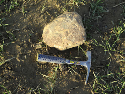
Friday, 22 October 2021

Gibbing Greave & Herringthorpe Wood

 
Exposures of sandstone at Great Bank Quarry

Having completed the first leg of my investigation of the Pennine Upper Coal Measures Formation (PUCMF) in Rotherham, at Listerdale and Brecks Woods, I made my way up to the path that would take me to Gibbing Greave – a small area of woodland that I had discovered, along with Herringthorpe Wood, on the Casual Ramblers website.
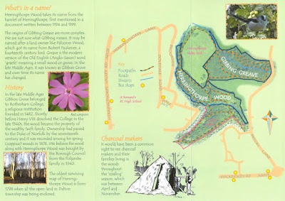
 
Gibbing Greave and Herringthorpe Wood

Apart from the fact that both woods have streams running through them, which might expose some mudstones and siltstones, these were green spaces in Rotherham that I had not visited and at the southern end of the Herringthorpe Wood was the disused Great Bank Quarry, which I had visited briefly in 2017 with a few members of SAGT (Sheffield Area Geology Trust).
 
Entering Gibbing Greave, it took less than 15 minutes to complete my investigation of the stream banks, with the only points of interest being further examples of head and the development of a spring on the south side of the stream, whose flow had exposed isolated patches of flaggy sandstone at the junction with the stream.
 
A spring in Gibbing Greave
 
Leaving the wood, I stopped for a few minutes to take in the panoramic views to the north and north-west of Rotherham, with Hoober Stand – one of the Wentworth follies – just visible in the distance, standing on a ridge of Abdy Rock.
 
Hoober Stand on the escarpment of Abdy Rock
 
Continuing to Herringthorpe Wood, I didn’t notice anything of particular geological interest and, stopping only to photograph a large bumblebee that had caught my eye, I hurried on until I reached Great Bank Quarry.
 
A bumblebee in Herringthorpe Wood
 
The quarry is one of the RIGS (Regionally Important Geological Sites) in Rotherham that I did not visit myself and, at the time of the survey in 1989, the British Geological Survey placed it on the Dalton Rock. The 1957 memoir describes it as “yellow, medium-grained sandstone with micaceous and carbonaceous partings and with plant debris”; however, on the latest edition of the map, it is now marked as an unnamed sandstone in the PUCMF.
 
A general view of Great Bank Quarry
 
On the north side of the quarry, there is a good example of massive sandstone with large scale cross-bedding, which passes upwards into flaggy beds – as can also be observed in several exposures at the old quarries in Canklow Wood.
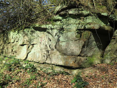
 
Large scale cross-bedding in massive sandstone
 
On the west side, although some of the rock face has been blackened with fires created by youths that are attracted to old quarries like this, various other interesting sedimentary structures can still be quite clearly seen.
 
Differential weathering of siltstone and mudstone

I don’t know anything about the history of this quarry, but the differential weathering of the soft siltstone and mudstone has highlighted the limitations of this stone for use as a building stone – and I can imagine that this sandstone has only been used locally as a general walling stone.
 
Carbonaceous beds at Great Bank Quarry

Looking closely, the carbonaceous beds described in the memoir are quite obvious, although I didn’t seen any plant material. On the right hand side of the quarry, where I collected a couple of samples, there are high levels of iron in the medium/coarse grained sandstone – with a general staining of the rock and the development of thin bands of dense ironstone.
 
Samples collected from the quarry face

I also collected a couple of samples from one of the banks of discarded material that lie at the entrance to the quarry. These are light brown in colour, with some light iron banding and are much finer grained and flaggy in nature.
 
Samples collected from a waste heap

Tuesday, 19 October 2021

In Search of the Dalton Rock

 
A small exposure of the Dalton Rock
 
Having abandoned my search for the Wickersley Rock in the Listerdale Estate, I carried on with my walk through Brecks Plantation and Black Carr, where I had identified a couple of streams on the Ordnance Survey map, which emerge from beneath Wickersley Rock and flow across older mudstones of the Pennine Upper Coal Measures Formation.
 
The area around the Brecks and Listerdale

These and a couple of other streams converge to form Dalton Brook, which occupies a moderately deep valley that has been cut into the Dalton Rock and flows northwards to Dalton and then on to the River Don.
 
As at Shirtcliff Wood and Bowden Housteads Wood, I had hoped that I would find exposures of rocks in the hillside or in the stream banks. Within a few minutes, I found a place where numerous small pieces of flaggy sandstone littered the slope beside the path and, looking very closely, a few very small outcrops could just be seen.
 
Barely visible outcrops of Dalton Rock
 
Thinking that this was probably the Dalton Rock, I obtained a decent sized sample with my Estwing hammer for later examination and carried on with my walk to find a streamlet – far away from the old quarries - that was full of large pieces of worked sandstone.
 
Blocks of worked sandstone

I would have to speak to a local historian to further obtain information about these, together with others that seem to be randomly scattered around the area - including a large block of sandstone that had apparently been recently sampled by another geologist before me.
 
A previously sampled block of sandstone
 
I collected one of the pieces of stone that had been discarded and then went to explore the stream banks, where I found exposures of head, composed of large unsorted fragments of sandstone and soil that had moved down slope by solifluction during the Quaternary Period.
 
A stream section through a deposit of head

The whole area seems to be covered in such unconsolidated material and I didn’t see any signs of the Dalton Rock, with the only bedrock exposed being the occasional mudstone, including one relatively large section that has been partially weathered to yellow clay.
 
Mudstone weathered to yellow clay

After looking at the various stream banks, I started to make my way up the path towards the east side of the Brecks housing estate, where I discovered another small exposure of Dalton Rock, with flaggy beds similar in thickness to those seen near Black Carr.
 
An exposure of flaggy Dalton Rock

The four samples of sandstone that I collected are all medium grained and micaceous, with similar light brown/yellowish colouring that is a result of iron staining and, although I would like to see a sample of the Wickersley Rock for comparison – and ideally undertake an examination with a petrological microscope – I feel confident that I now have some Dalton Rock in my collection.

Specimens collected when investigating the Dalton Rock

Monday, 18 October 2021

In Search of the Wickersley Rock

 
The entrance to the Listerdale Estate

In the last week of March 2021, although the COVID-19 Pandemic restrictions were still limiting my options for a day out, I now owned an Estwing hammer and, following on from my investigation of the Quaternary Geology in Rotherham, I decided to investigate some of its Pennine Upper Coal Measures Formation strata.

Many years ago, I was taken to an old quarry within the private Listerdale Estate, where the Wickersley Rock was extensively exploited for local building stone and for grindstones – which were once in great demand by the cutlery industry in Sheffield.
 
A LIDAR map showing old quarries in the Listerdale Estate

I have no records of having surveyed the area for the South Yorkshire RIGS (Regionally Important Geological Sites) Group back in 1989, so I decided to investigate further. Having arrived at the Brecks on the X1 bus from Rotherham, I made my way through the housing estate to the area where the old quarries are quite clearly shown on a LIDAR map.
 
A view of the old quarried landscape in the Listerdale Estate

Although I encountered very many overgrown depressions that had obviously been small quarries, and there very many loose blocks of stone lying around, I recalled that the extensive quarry face that I had seen was below the escarpment, but I couldn’t see any sign of it
 
A general view of the Listerdale Estate

Perhaps, as with Canklow Woods, the old quarries had become so overgrown that they would be missed by a casual visitor and that it would need someone with a good knowledge of the area to point them out; however, on this occasion, I had a full itinerary and decided that my search for a piece of Wickersley Rock would have to wait for another day.
 
An area of woodland littered with blocks of sandstone
 

Wednesday, 13 October 2021

More Quaternary Geology in Rotherham

 
Various rocks collected on the way from Todwick to Wales

Arriving at the eastern outskirts of Todwick on the public footpath from Axle Lane, with my pockets full of pebbles that I had collected from the remains of Quaternary deposits that are found in this part of Rotherham, I made my way through the village on the path to Wales.
 
The area between Todwick and Wales

The footpath here again runs alongside a ploughed field, at the edge of a housing estate, before heading south-south-west towards a small brook, which flows from the higher ground formed by the Mexborough Rock to the east.
 
The footpath from Todwick to Wales
 
This area of land is marked as glacial till on the British Geological Survey map and, within a few seconds of starting off along this path, I encountered numerous light brown pebbles of a type that I had seen on the first leg of my walk – one of which I broke open with my Estwing hammer with some difficulty, to reveal fine grained Carboniferous sandstone.
 
A pebble of fine grained Carboniferous sandstone
 
Working my way along the path across the muddy field, where an unidentified crop was in its early stages of growth, I could easily have collected as many rocks that I already had on my person - and which were starting to weigh me down.
 
Pebbles next to the footpath from Todwick to Wales

Having been very glad that I had put my walking boots on, I came across a few more very interesting rocks - including a large piece that had apparently been previously collected and set aside next to a fence post at the end of the path.
 
A large specimen found in the glacial till

On its weathered surface, its grey and siliceous appearance reminded me of chert but, after many attempts to break it open, there is no conchoidal fracture - which is typical of the chert from the Carboniferous limestone that I am familiar with. In places, the fresh surface of the sample has orange staining, suggesting localised concentrations of iron bearing minerals.

A specimen that is possibly chert

At the same locality, I found another equally mysterious rock, composed of loosely interlocking pale green/grey crystals and with many vesicle like voids. When tested with hydrochloric acid, it effervesced moderately and it again proved exceedingly difficult to break.
 
A rock with intergrowths of crystals
 
Carrying along the path to Wales, I encountered vast numbers pebbles of Carboniferous sandstone and red and brown quartzite, amongst other rocks, but by now I had stopped collecting these. By the time that I reached the path that turned west to Storth Lane, I had left behind the patch of till and pebbles in the soil were now very infrequent.
 
Pebbles of Carboniferous sandstone and quartzite
 
On this path, I collected my last rock of the day, taken from a small erratic that was lying isolated in a field and that I guessed was some kind of coarse sandstone, judging by its surface texture, although it has a colour that is similar to some of the Permian dolomitic limestones that outcrop further to the east.
 
A small erratic next to the path to Storth Lane

When examining a piece at home, I tested it with hydrochloric acid test but there was no reaction and it would not scratch with my steel knife, which suggested that it was composed essentially of quartz grains; however; examining it with a hand lens, the coarse angular grains are not clear quartz, but an opaque pale cream mineral that, with some rounded grains, are set in a similarly coloured matrix.
 
A sample of an erratic on the path to Storth Lane

Finally arriving in the centre of Wales, I stopped to have another look at an unusual feature that I had discovered a few years earlier, when investigating its mediaeval church and other historic buildings in the oldest part of the village.
 
An old doorway on Manor Road

On the west wall of an outbuilding to The Beeches on Manor Road, a blocked doorway has jambs made of Rotherham Red sandstone and, within one of these, a couple of large unusually shaped embedded fragments are weathering out of the stone.
 
Inclusions in Rotherham Red sandstone

The only inclusions that I have seen in the Rotherham Red sandstone are ironstone pebbles, which are sometimes concentrated into conglomeratic beds, and I wondered if these might possibly be pieces of fossilised bone.

An inclusion in Rotherham Red sandstone

Being set in the wall of a private property next to a listed building, I obviously couldn't consider trying to remove them, but I think that a palaeontologist would be interested in seeing them in situ. For now though, along with many of the specimens that I collected on a very enlightening day, they remain a mystery.

An inclusion in Rotherham Red sandstone

Tuesday, 12 October 2021

Quaternary Geology in Rotherham


Rocks collected on the walk from Kiveton Park to Todwick

On a few occasions, when exploring the area around the Chesterfield Canal during the summer of 2020, I came across places on the Magnesian Limestone where the fields were strewn with rounded and sometimes faceted pebbles of Carboniferous sandstone.
 
These are not marked as superficial deposits on any map, but the Geological Survey of Great Britain memoir, published in 1957, mentions in the introduction to Pleistocene and Recent deposits that there are “a scattering of pebbles to show where more substantial deposits must have been” – with these being found on high ground.
 
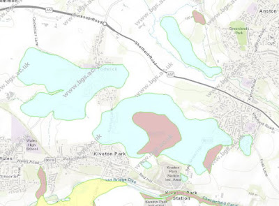
Superficial deposits in the area around Kiveton Park

For my next day out, following my investigation of the Treeton Rock, I planned a walk that followed various public footpaths across a part of rural Rotherham, where the British Geological Survey map shows that the bedrock is covered in till and head - laid down during the Quaternary Period.
 
An Ordnance Survey map showing footpaths around Kiveton Park
 
In the area covered by the Sheet 100 Solid and Drift 1:50,000 geological map, less than a handful of sections of till had been recorded, with it being mostly necessary to map the till by observing areas of clayey soil with concentrations of erratics.
 
The public footpath to South Anston

Arriving on the X54 bus at the stop nearest to Kiveton Farm Fisheries and walking east towards South Anston, the ploughed fields presented a featureless landscape that sloped up to the Magnesian Limestone escarpment in the distance; however, there was no sign of the typically reddened soil from the underlying bedrock, which here is Rotherham Red sandstone.
 
An exposure of loamy soil adjacent to the footpath
 
At the edge of the well used wide track, which has been repaired/reinforced in brick and possibly other materials, bare patches of light brown loamy soil are seen to contain numerous pebbles of various shapes and sizes – most of which looked similar to the Carboniferous sandstone pebbles that I had previous seen and interpreted as being glaciofluvial in origin.
 
Loamy soil with abundant pebbles

Carrying on along the track, looking in the soil that could be seen beneath the crop that was now growing in mid-March, within a few minutes and over a short distance, I also found pebbles of vein quartz, red and brown quartzite and others that I thought might possibly be igneous - and pieces of granite and volcanic green slate that are probably building materials.
 
A broken pebble of quartzite
 
Their polished nature makes it difficult to positively identify these pebbles and, although one that I was able to break open with my Estwing hammer was revealed to be a quartzite, others would not break under sustained hammer blows.
 
An old quarry at Kiveton Park

I then took a diversion to Lodge Hill Pond, where a large erratic of volcanic agglomerate from the Lake District had been recorded, but I couldn’t find it and continued south to quickly look at the old quarry to the north of Kiveton Park station, before returning back to the track to South Anston. 
 
Fragments of Rotherham Red sandstone in ploughed soil

I had so far crossed over the areas of both till and head, without seeing any difference between them - which may be possible when crops are not growing. Turning northwards onto the path that marks the boundary between Anston and Todwick, I noticed that the pebbles had disappeared, the reddened soil above the bedrock had reappeared and the only rock fragments visible were small pieces of Rotherham Red sandstone exhumed by ploughing. 
 
Fragments of Rotherham Red sandstone
 
Arriving at the path that runs eastward into Axle Lane and South Anston, I followed it to the west and, after stopping to photograph the Magnesian Limestone escarpment to the north, I carried on along the path next to the ploughed field until I reached Todwick.

A view north towards the Magnesian Limestone escarpment