Wednesday, 22 December 2021

Grange Moor Quarry to Kimberworth

 
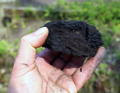
Waste shale from a bell pit in Kimberworth

My exploration of the geology of the area around Grange Park, near Kimberworth in Rotherham, had so far been very productive, with my investigation of the Thundercliffe Grange quarries and the discovery of coal smut in Ockley Bottom.
 
An old quarry face on Droppingwell Road

Arriving at Droppingwell Road, I immediately encountered an isolated old quarry face at the northern end of Grange Moor Quarry, which I didn’t see during my geological survey for the South Yorkshire RIGS Group back in 1996.
 
Flaggy beds overlying massive sandstone at Grange Moor Quarry

Spending only a minute to take photographs of the flaggy, cross-laminated beds that overlie a massive sandstone, which looked similar to those that I had seen in Barber Wood half an hour earlier, I walked down to the main entrance of the quarry.
 
A general view in Grange Moor Quarry

I was very surprised to discover that an extensive, clearly visible quarry face was now largely obscured by well established trees and shrubs, which prevented me from taking a good look at the large scale characteristics of this exposure of the Silkstone Rock.
 
A section of Whinmoor Rock containing flattened nodules

Nevertheless, I soon found a place where I could get easy access to a nearby quarry face and obtain a sample with my Estwing hammer. Although fine grained, like the previous specimen, it varies in colour from light grey/brown to yellowish in colour, which reflects its iron content and contains flattened nodules that have differentially weathered to leave voids in the sandstone.
 
A specimen of Whinmoor Rock from Grange Moor Quarry

Leaving the quarry, I then made my way up Green Lane, where there is another sculpture by Marcela Livingston and good views along the escarpment formed by the Silkstone Rock, with the ridge of Grenoside Sandstone at Greno Woods clearly visible in the distance.
 
A view along the escarpment of the Silkstone Rock

As with many of the walks that I had undertaken in Rotherham and Sheffield since the start of the COVID-19 Pandemic 13 months earlier, even though I didn’t see that many exposures of the Pennine Coal Measures Group rocks, I did get a good appreciation of the topography and it gave me a better understanding of the geological map of the region.
 
A map of the geology to the north of the Lower Don Valley

At the top of Green Lane, there are also panoramic views to the south-west, where there is a good opportunity to appreciate the geomorphology of the area and it how it relates to the underlying geology – especially the effects of the Don Monocline at Wincobank, where the strike of the Silkstone Rock is SW-NE and the dip is up to 30 degrees to the south-east.
 
A panoramic view to the south-west from the top of Green Lane

Finally arriving at the outskirts of the old village of Kimberworth, I got talking to one of the locals about the history of coal mining in the area, who then informed me that the area was also exploited for ironstone and, like the area around Grange Park, there were once numerous bell pits dug into the Claywood Ironstone below the Silkstone Rock.
 
Today, most of the area has since been landscaped and there is very little evidence of the mining industry around Kimberworth but, although I had not noticed them when I encountered another Marcela Livingston sculpture at the top of Green Lane, a few of them are still intact.
 
Bell pits in Kimberworth

With plenty of time on my hands, I went to have a look for these bell pits and the Roman Rig, whose position is recorded on the Ordnance Survey map. Noting the line of the ancient dyke for further investigation, I then had a quick look at the mounds of waste from the bell pits and was interested to see that many pieces of the dark grey shale had a bright orange interior.
 
Waste shale at the Kimberworth bell pits

Tuesday, 21 December 2021

A Discovery of Coal in Ockley Bottom

 
A sample of coal smut from the stream in Ockley Bottom

Originally known as Droppingwell Wood and being much more extensive before Droppingwell Road was created, the Fuelling a Revolution leaflet states that much of Ockley Bottom overlies spoil from colliery workings.
 
An extract from the Fuelling a Revolution leaflet

The area around Grange Park has had a long history of mining, for coal and ironstone – dating at least back to 1161 when the monks from Kirkstead Abbey began mining the latter. Furthermore, a very large number of bell pits have been recorded, three deep mines once operated in the area and opencast mining was undertaken after WWII.
 
Former collieries in the vicinity of Ockley Bottom

Although I was aware of its mining history, I was mainly interested in the sandstone quarries on this occasion and, having had a good look at the Thundercliffe Grange quarries, I didn’t investigate any of the small exposures that I saw from the path that runs along the bottom of Barber Wood.
 
A small outcrop of Whinmoor Rock

The escarpment that I had been following turns sharply to the north and fringes a wooded valley and, even though I didn’t notice at the time, the path crosses over the line of the railway that led to Grange A Colliery, which was set near to the top of Droppingwell Road.
 
The stream running through Ockley Bottom

The stream that occupies the valley is culverted in its lower stretch and, after it emerges upstream, for some distance there are no signs of any stream banks where the Pennine Lower Coal Measures Formation strata might be exposed and, keeping to the path, the most interesting feature that I noticed was one of a series of cast iron sculptures by Marcela Livingston.
 
A sculpture by Marcela Livingston

When crossing the bridge over a part of the stream where the banks of its relatively deep channel here had been reinforced with stone walls, I noticed that some of the masonry had collapsed to expose the stream bank.
 
A masonry lined section of the stream

Continuing on the path towards Droppingwell Road, I was very interested to see an exposure of various sedimentary rocks, which were unlike those that I had recently seen at Bowden Housteads Wood, Shirtcliff Wood and Jervis Lum.
 
A stream bank exposure in Ockley Bottom

Instead of flaggy sandstone, siltstone and mudstone, which had often weathered to yellow clay, there is a section of what looks like the coarse brown/grey ash that I recall being taken away from the burnt out open coal fire when I was young.
 
A detail of the stream bank exposure

From this, in the upper part of the section, there protrudes a black layer with pronounced bedding planes and a similar bed occurs at a lower level a couple of metres downstream, which has a slight ochreous tinge in a couple of places.
 
Another detail of the stream bank exposure

Retracing my steps, I was determined to obtain a sample with my Estwing hammer and, even though access to this stream bank outcrop was not easy, I managed to get down to a place where I could hack off a small sample of what would be called coal smut – a black, earthy and worthless outcrop of a coal seam.
 
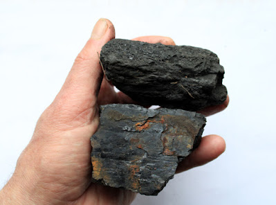
Samples of coal smut (top) and clean bright coal (bottom)
 
On the British Geological Survey Sheet 100 map, the Mickley Thin (Whinmoor Coal) is shown to outcrop below the sandstone escarpment (formerly known as the Whinmoor Rock) that I had been following from Thundercliffe Grange and, although it is not a clean bright coal here – as described in the accompanying memoir – it is probably this seam that is exposed in the stream bank. 
 
A geological map showing the Mickley Thin Coal (MN)

Sunday, 19 December 2021

The Thundercliffe Grange Quarries

 
A high level exposure of flaggy sandstone

After making my way down to Thundercliffe Grange, via a circuitous route through Grange Park, the path running along the base of the escarpment at Barber Wood was well marked and, after a short distance, I found the sandstone quarry that I had briefly inspected back in 1996 for the South Yorkshire RIGS Group.
 
I had expected it to be quite overgrown after such a long time but, although saplings have begun to occupy the quarry floor, it was pretty much as I remember it, with several faces of sandstone being exposed. Although a minor unnamed sandstone lying between the Penistone Flags (PF) and the Silkstone Rock (SR), it forms a prominent topographic feature.
 
A small squarry to the east of Thundercliffe Grange
 
Seen from a distance, the light brown sandstone looks quite massive, with no well defined pattern of jointing on the quarry face, but having noticed one area where there is a zone of narrow joints parallel to the quarry face, I went to have a closer look.
 
Jointing parallel to the quarry face

Here, an exposed angle on the quarry face has weathered away to reveal a section of very thin cross-laminated beds, where a high concentration of iron gives the sandstone a distinct orange colour – a characteristic that can be seen in very many of the blocks of stone used in Thundercliffe Grange, which were quarried locally.
 
An exposure of ornage cross-laminated sandstone

The sample that I took with my Estwing hammer is fine grained, light brown in colour with feint iron staining that is concentrated into a dense, less than 2 mm thick band of iron oxides/hydroxides on one of the fresh surfaces.
 
A sample of sandstone from the quarry east of Thundercliffe Grange

Continuing along the path at the lower edge of Barber Wood, I came across a barred entrance to another much larger quarry, which wasn’t on the list of potential RIGS to survey and where I immediately noticed that the upper section of the quarry face comprised very flaggy beds.
 
Flaggy sandstone in the quarry south-east of Thundercliffe Grange

Very often, the Pennine Coal Measures Group sandstones are seen to pass up upwards from massive to flaggy beds, which reflects the flow regime in the river channel in which they are deposited. Where exposed at the surface, the sub-aerial weathering processes that break down the rock exploit these bedding planes and the subsoil is usually well developed.
 
An exposure in the quarry south-east of Thundercliffe Grange

The access to the high level flaggy sandstone wasn’t very easy and I didn’t try and obtain a specimen of this. Although only an associate member of the Sheffield Area Geology Trust and I therefore no longer officially contribute to the designation or management of geological sites in South Yorkshire, as with the problem with the litter at Maltby Crags, I just took a few photos of the burnt out cars that had been dumped in this quarry to send to the relevant authority.
 
A burnt out car

Continuing along the path, the escarpment formed a persistent topographic feature and, although a LIDAR map indicated that there were further small workings, I didn’t see any good exposures and therefore carried on until I reached Ockley Bottom.
 
A view along the escarpment in Barber Wood

Grange Park in Rotherham

 
A sample of siltstone from the Grange Golf Club

After four successive days out to explore the historic buildings and building stones in Sheffield, which included several Sheffield Board Schools and the Leopold Street complex, my next trip was nearer to home, with an exploration of the area around Grange Park Woods in Rotherham.
 
The area around Grange Park in Rotherham

When looking for green spaces around Rotherham to investigate on the Casual Ramblers website, as with Gibbing Greave and Herringthorpe Wood, I thought that it would make a good walk. Also, in addition to revisiting the quarries that I had briefly surveyed for the South Yorkshire RIGS Group back in 1989, the Fuelling a Revolution leaflet highlights its history of coal mining and quarrying and evidence of this can be seen on the LIDAR map.
 
A LIDAR map of the area around Grange Park Woods

Alighting from the bus from Rotherham at the entrance to the Grange Golf Club on Upper Wortley Road, I stopped briefly to collect a sample from one of the blocks of siltstone that is set on the roadside and continued down to the clubhouse.
 
A block of siltstone at the entrance to the Grange Golf Club

At one point, seeing a distinct valley to the north of the greens that had been cut into the mudstones of the Pennine Lower Coal Measures Formation, I went to see if I could see any outcrops in the stream banks, but found nothing.
 
A stream on the Pennine Lower Coal Measures Formation
 
Having printed out a copy of a 1:25,000 Ordnance Survey map, which had so far served me well so far in my rural walks in Rotherham, I couldn't find the public footpath – even though this is part of the Trans Pennine Trail – and after identifying the ridge of Grenoside Sandstone and Greno Woods in the far distance as a landmark, I made my way down the escarpment.
 
A view towards Greno Woods from the Grange Golf Club
 
Although the path that I had taken didn’t seem to be the public footpath marked on my map, I was able to orientate myself by the area of woodland that forms Walkworth Wood and coincides with a ridge of an unnamed sandstone.
 
A view towards Walkworth Wood

Making my way to the bottom of the escarpment, where I asked a group of golfers for directions, I discovered that I wasn’t too far away from my destination and finally arrived at Thundercliffe Grange, dated 1776-85, by John Platt for the 3rd Earl of Effingham. With no access to the front elevation, I just took a single photo for the British Listed Buildings website and went in search of a quarry that I had last seen in 1996.

Thundercliffe Grange

Saturday, 18 December 2021

The Leopold Street Buildings

 
A detail of the Central School on Leopold Street

Arriving in Sheffield city centre, after my brief exploration of some of the historic buildings on London Road and the Sharrow Lane and Springfield Board Schools, I had very quick look at the complex of former education buildings, centred on the Sheffield School Board Offices on Leopold Street, which is now the Leopold Hotel.
 
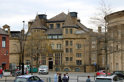
The Holly Building

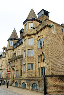
Approaching from the west end, the first building that I saw was the Holly Building, the last of this group of buildings to be built, in 1899, to a design by H W Lockwood of Sheffield – another architect whose work I am not familiar with.
 
The main door to the Holly Building

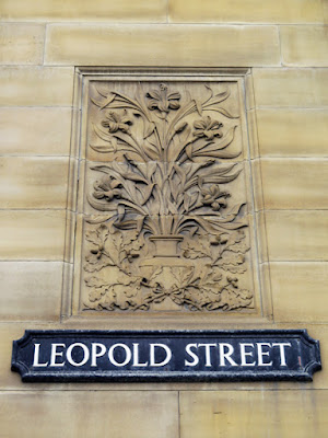
Its architectural style is unlike any of the Sheffield Board Schools that I had seen to date, with its symmetrical front having two canted four storey bays topped with spires, the building’s name in lettering with a floral background and further foliated decoration above the main door – including acanthus leaves at the base of a crenellated parapet, which has an eroded crest at its centre.
 
The Holly Building

I didn’t stop to look closely at the stonework, because I had other things to do before catching my bus back to Treeton but, based on my observations of the Sheffield Board Schools to date, I would have said that this was yet another example of the use of Crawshaw Sandstone for the rock-faced walling and Stoke Hall stone for the dressings.
 
The Science School on Orchard Lane

Walking down Orchard Lane, I thought that the stonework in the Science School extension by J B Mitchell-Withers, dated 1895, didn't look much different – except for the walling, which has larger blocks and a batted finish instead of being rock-faced.
 
A detail of the Science School

An article on the Sheffield Area Geology Trust website, however, mentions that the buildings on the Leopold Street site use the same Huddersfield stone, a medium grained sandstone from the Rough Rock at Crosland Hill, which has been used extensively for the Heart of the City developments in the centre of Sheffield.
 
A pediment above the Orchard Lane entrance to the Central Schools

On this occasion, with the light being quite poor, I was more concerned with taking a few photographs of the architectural details on the Central Schools building, with the intention of having a closer look at these buildings at some time in the future.
 
The Sheffied School Board buildings on Leopold Street

Certainly, the general uniform appearance of the ashlar masonry in the Central Schools is consistent with the Crosland Hill stone that is quarried at Huddersfield today and the sandstone used for ashlar on the Leopold Street frontage and for the School Board Offices and Firth College looks very similar.
 
The Sheffield School Board crest

The architects for Firth College (1879), the School Board Offices and the Central Schools (both 1880) were TJ Flockton, of the Sheffield firm Flockton and Gibbs and ER Robson, who was architect to the London School Board and a personal friend of the Sheffield School Board’s Secretary, JF Moss.
 
The entrance to the Leopold Hotel

The Renaissance style has been used for all three buildings and there is plenty of ornamental masonry, which is typically associated with commercial premises, where the owners are keen to emphasis their wealth. The School Board Offices has a grand front entrance with foliated stone carvings, an oriel window above it and a decorative frieze beneath the parapet.
 
The Sheffied School Board buildings on Leopold Street

Firth College, on the corner with West Street, was built on the part of the plot of the Sheffield School Board land that had been sold to Mark Firth, a wealthy industrialist and philanthropist who was a member of the Sheffield School Board, but who also had his own plans to build a new University College building.
 
The former Firth College

Originally two storeys in height, with an extra floor added in 1892, it is more simple in style than most of the other buildings but still has a very elaborate doorway, with the carved figures of Art and Science and smaller figures, by Edward Onslow Ford, occupying the spandrels.
 
The entrance to Firth College