Sunday, 15 November 2015

Carl Wark


A view of Carl Wark

Of the RIGS that I surveyed in the Peak District National Park, I identified the area around the top of the Burbage Valley as one of the best sites for education and geotourism; on a bright Sunday in mid September I took a much closer look.

An example of biodegradation in peat

For pleasure, I have always preferred to explore cities than taking long walks in rugged upland places and, with geological fieldwork relating to Geoconservation having effectively dried up, it had been a long time since I had dusted off my walking boots. When seeing the view of Carl Wark, it made me realise that I am not as young and healthy as I used to be.

A view of the scramble to the top of Carl Wark

Nonetheless, once I got going and had scrambled up to the top of Carl Wark, after crossing the muddy banks of Burbage Brook – where I had seen oily water seep from the peat – there are some spectacular views of the surrounding geology and geomorphology.

A view of Burbage Rocks from Carl Wark

Like Higger Tor and Burbage Rocks, which is one of the spectacular gritstone edges that form much of the eastern boundary of the Peak District National Park, the distinctive topography of Carl Wark is the result of the erosion of the Chatsworth Grit and associated shales, of Namurian age  it is also the site of an Iron Age fort, with substantial remains of an embankment and stone wall.

A view of Carl Wark from Higger Tor

Although the thick rock scree on three sides of the site obviously added to its defensive qualities, it is not that easy to study the large rock faces close up; however, the large boulders, which are slowly slipping down into the valley below, provide many opportunities to study the sedimentary structures and weathering of the very coarse, pebbly gritstone that is found here.

Pebbly Chatsworth Grit (20p coin = 21mm diameter)

Wednesday, 11 November 2015

The Peak District National Park


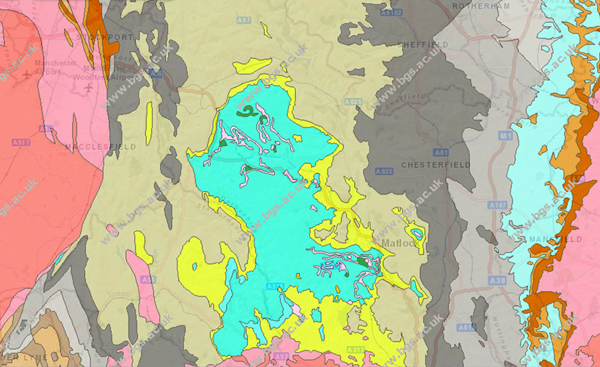
The Geology around the Peak District National Park

In the past year, whilst developing some of my ideas for Geotourism in and around South Yorkshire, using only public transport, I have visited old quarries, landscaped parks, various ancient monuments and historic buildings – as well as a few natural gorges.

The Roaches, Hen Cloud and Ramshaw Rocks

Added to the many other places that I know very well, there is more than enough to satisfy a group of Geotourists who want to know more about the geology, culture and language of England.

A glacial erratic formed from volcanic tuff

From where I live, it is also possible to drive to a Jurassic coastline, which is full of fossils, in just 2 hours, but one of England’s most spectacular landscapes is just on the doorstep. 

When living in Bakewell, I had the opportunity to survey the established RIGS within the Peak District National Park; there are so many places that I can think of - some much better known than others - which would satisfy both the hardiest walkers and the less energetic geotourists.

Stalagtites and flowstone in Treak Cliff Cavern

It is not surprising that aspiring geologists from all over England come to study the Carboniferous rocks and associated minerals that are found here - as well as general tourists who just appreciate the landscape.

Fluvio-glacial landforms

There is no better way to start exploring the Peak District National Park than to take a bus from Sheffield, and then get off at Fox House, Hathersage or Castleton - and have a good long walk in the surrounding countryside. 

Wednesday, 4 November 2015

Creswell Crags


Geotourism in South Yorkshire & Derbyshire

The arrival of spring is always a good time to start planning field trips for the year ahead. After seeing a few new places in West Yorkshire and revisiting Anston Stones Wood, my next idea came to me when I visited an exhibition at Weston Park Museum.

An extract from the 1957 BGS Memoir
Creswell Crags is internationally famous for the prolific mammalian remains and artifacts, which are considered to provide a complete stratigraphic record from Middle Palaeolithic to early post-Palaeolithic times. It is both a Scheduled Monument and a Site of Special Scientific Interest, for its palaeontological and archaeological value.

In 2003, the most northerly example of Rock Art in Europe was discovered here and - subject to confirmation of the date of recent finds in Jersey – it has been considered to be the oldest in Britain.

Although I had known about Creswell Crags - as one of the gorges that cut through the Magnesian Limestone - and I had attended a meeting there to discuss the Southern Magnesian Limestone Natural Area, whilst working with the South Yorkshire RIGS Group, this place still remained a mystery to me.

The caves are all gated and it is only possible to see Robin Hood Cave and Church Hole Cave as part of a guided tour, with the Rock Art being found in the latter. Here, in addition to seeing the engravings in the rock, there are good examples of flowstone and other solution features that relate to the formation of the caves.

Church Hole Cave

Access to the gorge itself is unrestricted and, although much of the rock faces are obscured by thick vegetation in the summer, there are still plenty of outcrops where the characteristics of the upper subdivision of the Cadeby Formation - the Sprotbrough Member - can clearly be seen. In contrast to the lower Wetherby Member, which is generally well bedded, with ooliths and various small fossil shells - as well as bryozoan reefs - the limestone is strongly wedge bedded and virtually unfossiliferous.
 
The bedrock geology at Creswell Crags

As a tourist attraction, Creswell Crags is very popular and it would probably appear on my field trip itinerary for Geotourists, although I think that 3 hours spent here is more than enough and that it should be combined with other sites in the area.