Friday, 2 December 2016

St. Mary the Virgin - Beighton


A general view of the south elevation

In the Domesday Book, no mention is made of a church in Beighton and, based on a late Norman arch that was found during late Victorian rebuilding, a date of c.1150 has been assigned to the church of St. Mary the Virgin.

A general view of the north elevation

No remains of the Norman church exist and - looking at the exterior - the Decorated Gothic style of the windows to the aisles indicates a 14th century date, with a later addition of the tower in the 15th century; both of these contrast strongly with the later additions of the chancel, clerestory and porch in the late 19th century, which includes new Welsh slate roofs.

The Victorian chancel

Although blackened in places, the general colouration and weathering characteristics of the stone - throughout the church - are similar to that seen in the oldest historic buildings in the village and it is therefore likely that its quarry source was also local.

A Decorated Gothic style window in the north aisle

A closer examination shows that both the south and north aisles are constructed with large, well squared blocks laid in courses with moderately regular bed heights; however, in the tower, there is much more variation in the bed heights and the west window – made of Magnesian Limestoneis in the Perpendicular Gothic style.

The west window to the tower in dolomitic limestone

T
he masonry in the Victorian additions is formed of much smaller blocks and is generally lighter in colour, having not yet developed a dark patina like that seen in the mediaeval structure. As a building stone, the sandstone used here is moderately durable but, like other Pennine Middle Coal Measures Formation sandstones, it contains beds of silt that are susceptible to weathering and it would only have been used locally.

A weathered gargoyle on the tower

Thursday, 1 December 2016

In Beighton


The Primitive Methodist Church in Beighton

Having undertaken surveys of the geology, mediaeval churches and various historic buildings that are set on or near to the known outcrop of “Rotherham Red” sandstone – from Hooton Roberts to Harthill – I took advantage of a rare shopping trip to Crystal Peaks shopping centre and walked around the village of Beighton.

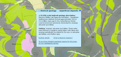
A geological map of the area around Beighton

Set on an unnamed Pennine Middle Coal Measures Formation sandstone, of similar age to those already encountered in the villages of Wales and Treeton, I wasn't surprised to discover that the various historic buildings here are constructed of yellow/buff/brown sandstone, with some iron stained bands – typical of the Coal Measures sandstones.

Victorian houses with thin bedded sandstone walling

In very many quarries excavated into these sandstones, a section through the quarry face will show a succession of beds of various thickness and grain size – with the massive beds being selected for the principal structural elements and finer, thinner beds being used for general walling.

An old quarry in Beighton

Getting off the bus on Robin Road, the Primitive Methodist Church provides a good example of this style of construction, as do the various Victorian terraced houses that run alongside High Street; however, the oldest houses – which include those of the more wealthy landowners – are generally built entirely in massive, medium grained sandstone.

A Georgian house built out of massive, medium grained sandstone

Having had a good wander around the old village of Beighton – and taking good note of its topography - I then set off to explore the church of St. Mary the Virgin.

Sunday, 27 November 2016

St. John the Baptist - Hooton Roberts


A general view of the church of St. John the Baptist in Hooton Roberts

An exploration of the geology and architecture of Hooton Roberts shows that distinctly red sandstone bedrock occurs very near to St. John the Baptist's church and that boundary walls and the walling to many of the oldest secular buildings are also built in a stone that I would describe as “Rotherham Red” sandstone.

The 15th century tower

A quick walk around the church - set in a small churchyard with steeply falling ground marking its northern boundary - reveals that it is also mainly built out of red sandstone and some mottled yellow varieties, with buff/brown sandstone used in most of the rebuilt chancel, for restored windows and general repairs to the fabric.

A view of the chancel and a neighbouring house

The English Heritage listing describes it as having a 12th century core, with rebuilding in the 15th century and extensive restoration during the Victorian period. Rubble masonry is visible in the north side of the nave and chancel and parts of the south aisle, but the tower and later extensions are built with much more precisely squared blocks of sandstone.

The north elevation of the nave

On this occasion, like others that I have visited during my investigation of the building stones and construction history of mediaeval churches in and around South Yorkshire, I was unable to see the interior of St. John the Baptist's church and the remaining Norman arches, because it was locked.

A general view of the south aisle

Saturday, 26 November 2016

Hooton Roberts Village


A view up Holmes Lane

On Holmes Lane in Hooton Roberts, although I did not have a compass clinometer to measure the actual dip of the small outcrops of rock on either side, my observations seemed to suggest that it is in the opposite direction to that seen in the strata to the south of the River Don  - from Rotherham to Denaby - which are affected by the Don Monocline.

A general view of Hooton Roberts

My old paper BGS map marks a fault just to the north-west of this outcrop, with a downthrow in this direction, and it has made me wonder if the map is actually correct; however, without investigating this further, I continued my investigation of the “Hooton Roberts Rock” by surveying some of the old buildings that can be found in this village.

The Earl of Strafford

The Earl of Strafford public house, built around the turn of the 17th century and considerably enlarged in the later part of the 18th century, is the oldest listed building in Hooton Roberts – apart from St. John the Baptist's church – and its walls are built out of “Rotherham Red” sandstone, with the quoins and dressings made from a buff/brown variety of sandstone.

Sandstone dressings at the Earl of Strafford public house

When undertaking a survey of the geological sites in Rotherham for the South Yorkshire RIGS Group, back in 1989, I very briefly visited the Hooton Quarry, which is excavated into a buff/brown variety of Mexborough Rock – 1 km to the west of the village – and this is very likely to be the source of these dressings.

The Coach House

Many of the agricultural and vernacular buildings of a later date are wholly built using this stone but several others use this together withRotherham Red” sandstone, and it also appears in some of the boundary walls that run alongside the main road.

Boundary walling in Hooton Roberts

No evidence of old quarry faces has yet been seen in the village, which would show the extent of the colouration of the rock here, but the abundance of red sandstone - and the need to reduce the cost of transport for stone used for simple vernacular architecture - would suggest that the deep blood red stone used to build houses next St. John the Baptist's church was quarried nearby.

Vernacular architecture in Hooton Roberts

Monday, 17 October 2016

"Hooton Roberts Rock"


A detail of the "Hooton Roberts Rock" in situ

When I first visited Rotherham 35 years ago - as an undergraduate geologist - I became aware of the very distinctive variety of Mexborough Rock that is known locally as “Rotherham Red” sandstone, which has been used extensively as a building stone in Rotherham and the villages in the south of the borough where it outcrops.

A view of the landscape around Hooton Roberts

Especially when there are no crops growing, the red staining of the soil is obvious and, having since surveyed much of the geology of Rotherham and its historic buildings, I have always thought that the village of Hooton Roberts was built on or very near to this rock.

Red sandstones in Hooton Roberts

Continuing with my investigation of the mediaeval churches of Rotherham, when I planned my first visit to St. John the Baptist's church – whose oldest externally visible fabric is built out of very strongly coloured red sandstone - I was surprised to discover that it is shown on the British Geological Survey map viewer as a Pennine Upper Coal Measures Formation sandstone.

Yellow sandstone in boundary walls at Hooton Roberts and Thrybergh

This generic name is used to describe a rock formation that does not possess physical or palaeontological characteristics – or is not sufficiently extensive or prominent as a landform – to make it so distinctive from another sandstone to give it its own name.

Cleaned samples of "Rotherham Red" sandstone and "Dalton Rock"

Without having the resources of the British Geological Survey at your fingertips, and access to the vast collection of rocks and other information that has been acquired over the years – or full authority to enter upon land without objection – it is not easy to contest the findings of an institution that leads the world.

An investigation of the "Hooton Roberts Rock"

My copy of the 1989 reprint of the 1947 edition BGS memoir, which accompanies the Institute of Geological Sciences map - Barnsley (Sheet 87) enlarged to 1:50,000 scale and reprinted in 1976 - describes the sandstone underlying Hooton Roberts as either Dalton/Brierley/Great Houghton/Cadeby or Hooton Roberts Rock.

Bullrushes and other water loving plants growing on a spring line

Getting off the X78 bus at the first stop after Hooton Roberts, on the way to Conisbrough and Doncaster, I walked down the hill to the village and stopped several times to take photographs of mapped areas of Mexborough Rock, a spring line and various boundary walls - from which I collected a few samples of loose stone.

Foundations of the churchyard wall at Hooton Roberts

Finally arriving at St. John the Baptist's church, I examined the bedrock that forms the foundations of one of its boundary walls and - having had a conversation with an owner of one of the surrounding houses where excavation in the basement revealed a very red sandstone - I decided that it was time to invest in a new compass/clinometer to make some dip and strike readings.

Thursday, 13 October 2016

Sculpture & Monuments


St. Leonard's Cross

As with many of the mediaeval churches in South Yorkshire, St. Leonard's church has a highly weathered carved shaft of an ancient cross in its churchyard – made of Magnesian Limestone. Along with a niche in the south elevation of the chancel, it is the only example of this type of stone seen when walking around the exterior of the church.


Victorian head stops

Looking up to the top of the 15th century tower, gargoyles sprout from each corner and various head stops to various windows and the porch – added in the 19th century – provide some fine examples of stone carving in Carboniferous sandstone of unknown provenance.


A view of the nave from the chancel

Once inside the church, apart from the narrow sandstone arches arches to both the chancel and tower and a small section of walling left exposed in the plastered walls, it is the various monuments that are of most interest to the geologist.


Monuments carved in various decorative stones

Taking advantage of an offer to be guided around the interior of the church, after talking to various local residents when photographing the Buttercross in Thrybergh, I didn't have the time to examine any of them closely, but the monuments on the walls provide fine examples of various decorative stones that were favoured by memorial masons from the early 16th century onwards.


The chantry tomb of Sir Ralph Reresby

The highlight of this quick tour of yet another mediaeval church in South Yorkshire, which has a fascinating construction history, was the opportunity to see the chantry tomb of Sir Ralph Reresby and other defaced 14th century effigies – all of which are carved from Magnesian Limestone.


A 14th century effigy of a priest


Sunday, 9 October 2016

St. Leonard's Church


A general view of St. Leonard's church in Thrybergh

Approaching St. Leonard's church from its main entrance on the road from Thrybergh to Doncaster, the sandstone walling seen in boundary walls – with its distinctive yellow colour – has been quarried from the Dalton Rock; however, as previously seen in the boundary walling on the Doncaster road, some of the blocks have a reddish tinge similar to “Rotherham Red” sandstone.

Colour variation in sandstone to the boundary walling

Looking at the church as a whole - essentially comprising an aisleless nave extended in the 12th century, a 14th century chancel, a 15th century tower and a 17th century porch - the principal building stone is yellow/buff coloured sandstone, which suggests that it has been mainly quarried from the Dalton Rock.

Evidence of extension, restoration and repair to the north elevation

A closer examination of the external fabric reveals considerable variation in the style of masonry between these different periods, with rubble walling and roughly shaped quoins used for the oldest parts of the structure and squared and coursed ashlar for later additions, as seen in other mediaeval churches in the region.

Various phases of restoration to the south elevation of the chancel

Various phases of restoration have taken place over the years - by Victorian architects in 1871 and 1874 and as part of later essential repairs to the relatively soft Dalton Rock - and this makes it difficult to analyse the construction history of St. Leonard's church in a brief visit.

A detail of the masonry on the north elevation of the nave

As with other churches in South Yorkshire that are considered to have been built around the time of the Norman conquest of Britain in 1066, the dating of the masonry has been the subject of debate. Sir Nikolaus Pevsner and English Heritage assign it to the Norman or overlap period, but the official church guide suggests a date of c.900 AD.

A blocked doorway with irregularly shaped quoins

The masonry to the jambs of the blocked door and the quoins to the south side of the nave is very irregular and uses very local stone, in a similar way to the oldest visible walls at St. John the Baptist's church in Wales.

A detail of quoins to the north elevation of the nave