 |
| On the bus from Rowsley to Bakewell |
Continuing with my walk from St. Peter’s church in Edensor to Rowsley, having had a good look at the well developed spring and Edensor Mill, I carried on alongside the River Derwent until I came to One Arch Bridge – built by James Paine in 1760.
 |
| One Arch Bridge |
After crossing the B6102, I followed the path up to Chatsworth Garden Centre and continued along a minor road until I arrived at Calton Lees, a hamlet composed of a wide variety of agricultural buildings and accompanying cottages.
 |
| Calton Lees |
I didn’t have a map with me and, with the signposting here being infrequent, I stopped to ask for directions and I then made my way along relatively high ground formed by the Marsden Formation; however, the path soon headed back down to a large spread of lowlands that were still very wet and extremely muddy after the heavy rain in February.
 |
| The geology around the River Derwent |
South of One Arch Bridge, the valley of the River Derwent occupies an inlier of the Bowland Shale Formation, mainly comprising impermeable mudstone, and the path that runs straight along the floodplain at times was sometimes impassable – especially at gaps in dry stones walls, which were also used by farm machinery.
 |
| Muddy ground on tthe Bowland Shale Formation |
Having at one point needed to clamber over a section of disintegrated dry stone wall and make my way across other boggy ground, I continued along the path to a point where it crossed a small dike that was discharging into the River Derwent, which by now was only a few metres away.
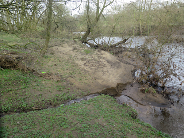 |
| Freshly laid silt on the riverbank |
Getting near to the river bank, I was interested to see a large expanse of freshly laid sediment that had been deposited by the river at the height of the recent flooding. The parts furthest from the river were already being recolonized by plants, but those nearest are seen to compose finely laminated layers of silt and a slightly darker material – possibly organic.
 |
| A recent deposit of silt |
The path turns into a track that heads up onto the higher ground formed by the Marsden Formation and, although covered in Carboniferous limestone aggregate, was again extremely muddy and, being used by farm vehicles, was very difficult to traverse in places.
 |
| A very muddy track |
During my walk from Edensor, apart from the small exposure of flagstone exposed by the spring in Chatsworth Park, I can't recall seeing seen any other outcrops of rock but, arriving at an area of open ground, I stopped to photograph a small knoll like outlier of Ashover Grit in the distance, which forms the northern end of a ridge that has been widely exploited for building stone at Stanton Moor and Birchover.
 |
| A knoll of Ashover Grit |
Just before entering Rowsley, I encountered the railway viaduct over the River Derwent, which was used until the line closed in 1967, and carried on to Church Lane, which I recognised from my last visit to the village in 2016. Stopping only to clean the mud off my boots as best as I could, I finished what had turned out to be an energy sapping walk and caught my bus back to Bakewell.
 |
| Rowsley railway viaduct |
No comments:
Post a Comment