Continuing our recce of the western end of Otley Chevin Forest Park, where the signposting is not so clear, Paul and I went in search for marker No. 4 on the Geology Trail that depicts the Carboniferous horsetail Calamites, to which the much smaller modern species are closely related.
Crags of the Doubler Stones Sandstone and very large slipped blocks are exposed here. They display prominent slumped bedding and soft sediment deformation structures, which are caused by dewatering and highlighted by differential weathering of the graded beds.
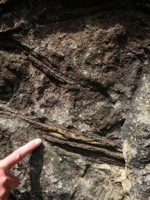
One particularly large block has been rotated at 90 degrees, which can be determined by the vertical orientation of the well defined cross-bedding. On the exposed bottom surface are several fragments of fossil tree branches, which would have been washed down the river after a flash flood and deposited as a log jam.
We had a good wander around the crags looking at the various sedimentary structures, without finding marker stone No. 5; however, there was no problem finding several large slipped blocks, where the cross-bedding is highlighted by the thick covering of moss and there are further examples of deformation structures.
Following the path past a pond, the next stop was another outcrop of the Doubler Stones Sandstone at the south side of the disused Yorkgate Quarry, where marker stone No. 6 shows dimpling of the rock surface cause by fossil tree roots.
The sandstone here dips to the south at an angle of 24 degrees and, taking care not to slip on the slope, we made our way to the top of the outcrop and searched for the fossil roots on the bedding plane, although these were not easy to see even after we had got our eye in.
Collecting a couple of pieces of sandstone from a part of the outcrop that had been indiscriminately hammered, the carbonised tree roots are quite clearly seen with the naked eye. An examination of this yellow sandstone with a hand lens further reveals it is medium/coarse grained with a scattering of feldspar that is sometimes pink in colour.
In one small exposure, above the bed of sandstone with tree roots, is a grey fireclay – the soil in which grew the trees and vegetation that turned into coal – immediately above which is a thin seam of the Morton Banks Coal.
After taking a late lunch, we continued to marker No. 7 on the other side of the quarry, where the Geology Trail route leaflet refers to the Variscan Orogeny, seen at the beginning of the day at the East Chevin Quarry car park, but the sculpture depicts a stonemason’s hammer and chisel - as recorded in the general account of the geology.
The large quarry face here is not accessible from the footpath, but the steep 24 degree dip of the sandstone can be clearly seen, as can the change from very massive sandstone in the lower part of the quarry to the more flaggy varieties at upper levels, which are emphasised by surface weathering processes that lead to the formation of the soil profile.
Making our way along the path along the ridge to Surprise View, in the distance to the north can be seen a prominent landform known as Almscliff Crag. This is formed from Warley Wise Grit and, together with the Pendle Grit Member, forms the lowest sandstone in the Millstone Grit Group.
The craggy outcrop of the Doubler Stone Sandstone forms the crest of The Chevin and, as seen in the Chatsworth Grit along the gritstone edges in Derbyshire, it comprises a very coarse grained sandstone with an abundance of quartz pebbles.
Marker No. 8 is a carving shows the swirling, fast moving currents that would have transported the very large pebbles of quartz along the ancient river bed. As with all the other markers seen on the walk, it is made of Midgely Grit from the Blackhill Quarry in Bramhope.
At Surprise View, there is an excellent interpretation panel that is dedicated to the geology and geomorphology of the region and to the Quaternary history of Wharfedale below, along which flowed a glacier that once covered The Chevin.
Having completed the Geology Trail, before heading back down to the car park, we finished the day by taking a quick look at the dry stone wall that was being repaired. I don’t if any new stone was being used, but it provides a good example of the range of colours and textures seen in the local stone, which includes some very bright red colouration.


No comments:
Post a Comment