 |
| A specimen of stigmaria from Broomhead Reservoir |
Wandering around St. Mary’s churchyard in Bolsterstone, I got a great panoramic view of the escarpment of Greenmoor Rock that runs to the north-west from Hunshelf Bank. This very fine grained sandstone produced the best quality paving stone, which I thought could be used to make the headstones in, but there is no record of this industry at Green Moor.
 |
| A panoramic view of the Greenmoor Rock escarpment |
When quickly looking at the exterior and interior of St. Mary’s church in Bolsterstone, even without getting close enough to touch it, I could see that it is built with a very coarse sandstone that I usually associate with the Millstone Grit Group, particularly the Chatsworth Grit in the Sheffield area, which often contains finger nail size pebbles.
 |
| The south door surround at St. Mary's church |
Looking at the geological map of the area, Bolsterstone itself is set on the Rough Rock, which has been quarried at the top of the escarpment a short distance away to the east. Where I have seen the Rough Rock in Whirlow and around Ringinglow, it is quite fine grained and thinly bedded and was used for flagstones and stone slates.

I have seen a medium/coarse grained variety of the Rough Rock to the south of the very steep sided Ewden Valley at Spout House Hill, where a few small quarries are shown on the 1855 Ordnance Survey map, and the geological memoir describes the upper beds of the Rough Rock as a massive, coarse grained, sandstone.
 |
| Quarries recorded in the vicinity of Bolsterstone |
The Building Stone Database for England map explorer and the British Geological Survey map on which it is based, shows that an outlier of the Loxley Edge Rock has been extensively worked at the Allman Hill Well Quarry and the LIDAR map shows this quite clearly.
 |
| The LIDAR map of the Allman Well Hill Quarry |
The memoir states that the summit of the hill here is occupied by a “massive, coarse, in parts gravelly, feldspathic sandstone, which, but for the occurrence of the Ganister Coal some 30 to 50ft beneath it, might be mistaken for one of the coarser beds of the Millstone Grits instead of a local phase of the Loxley Edge Rock”.
 |
| Very coarse grained sandstone used at the village pump |
I don’t know if any exposures or waste rock can still be seen at this quarry, which could be matched with the sandstone used at the church, but I think that it is quite likely that the stone used for it and other buildings in the village came from here.
 |
| Bolsterstone war memorial |
Having finished everything that we needed to do at St. Mary’s church for the Bolsterstone Graveyard Project, Catherine, Sally and I then had a quick walk around Heads Lane, Folderings Lane and Walders Lane – a distance of less than 300 metres - so that I could take some photos for the British Listed Buildings Photo Challenge, which included the K6 telephone kiosk, the village stocks and Bolsterstone war memorial.
 |
| Castle Cottage |
The Grade II Listed Castle Cottage, which dates back to the late C16 to early C17, is built in what the Historic England listing describes as deeply coursed rough ashlar gritstone, with thinly coursed rubble used for the C19 addition, but I didn’t get close enough to make my own assessment.
 |
| Views of Porters Lodge |
Porters Lodge is considered to be a greatly altered mediaeval building, with the shouldered lintels to the doors and windows and leaded glass giving it a chapel like appearance. Projecting from the south elevation is the jamb and springer of an arch that is believed to form part of the entrance to Bolsterstone Castle – a possible fortified manor house built by one of the Earls of Shrewsbury and on the east elevation is a reset mediaeval mask.
 |
| Vernacular architecture in Bolsterstone |
On this very short walk in Bolsterstone, I photographed various buildings that are built in a massive coarse grained sandstone, but they are too blackened to get any idea of the colour variation within the sandstone and I didn’t examine any of them closely.
 |
| Broomhead Reservoir |
To finish the day, Catherine asked me if I wanted to go and look at the shore of Broomhead Reservoir, where she had discovered that the drop in water levels over the extremely dry summer had revealed blocks of sandstone that were were full of Carboniferous plant fossils.
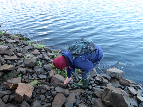 |
| Searching for fossils |
Although the water levels had since risen, we were still able to scrabble around and came across several blocks of sandstone with plant fossils in them. Palaeontology is not my strength and it was Catherine who spotted the stigmaria - the fossil root of a Carboniferous lycopod - that I took home with me but, once I got my eye in, I started to spot more of these.
 |
| A Carboniferous plant fossil |
Given enough time, I am sure that we could have found many other specimens, but I was grateful enough to be shown these at the end of what turned out to be my last outing of 2022. One rock that stood out against all of the other loose pieces of sandstone was a large piece of what I think must have been ganister, which looked extremely fine grained and very siliceous.
 |
| Ganister with a stigmaria plant fossil |
No comments:
Post a Comment