As an agricultural settlement, Dore originally constituted scattered buildings linked by tracks and originally with a network of greens, which were common land, but this pattern was dramatically altered by the Dore Enclosure Act in 1822, which was instigated by the Duke of Devonshire and various other landowners.
Like many villages around Sheffield, apart from having a predominantly agricultural character, Dore thrived during the Industrial Revolution and industries around here included the making of scythes, saws and files, coal and ganister mining, lead smelting, production of copperas and white coal and the nearby Limb Brook and River Sheaf powered various mills.
As also seen in Grenoside, Dore contains numerous listed buildings within the Conservation Area but they are predominantly simple vernacular and agricultural structures, without ornamentation, and it is the locally quarried stone for walling and roofing that gives the old village its character.
Except for a few buildings that I stopped to photograph, before I had collected my copy from the Dore Village Society Rooms, I followed the Dore Heritage Trail route from start to finish – a distance of 2 km; however, although I photographed all of the places on the trail, not all of them are noteworthy from the point of view of a geologist, with particular interests in historic architecture and building stone.
 |
| The Dore Heritage Trail |
Except for a few buildings that I stopped to photograph, before I had collected my copy from the Dore Village Society Rooms, I followed the Dore Heritage Trail route from start to finish – a distance of 2 km; however, although I photographed all of the places on the trail, not all of them are noteworthy from the point of view of a geologist, with particular interests in historic architecture and building stone.
Many of the buildings on the trail have significance for their connections with local families and industries but even those that date back to the C17 are generally very plain in nature, and I think that they are mainly of interest to an historian.
The Dore Stone, made of a slab of sandstone with an inscribed black Scottish granite shield, is an unusual memorial and this first caught my eye very many years ago when driving through the village. Although the materials used are very common, I particularly like the wyvern design.
Across the road, there is a very fine war memorial, carved from grey granite - from Devon or Cornwall - and set on a sandstone plinth, which is very uniform in colour and looks like it has been recently cleaned.
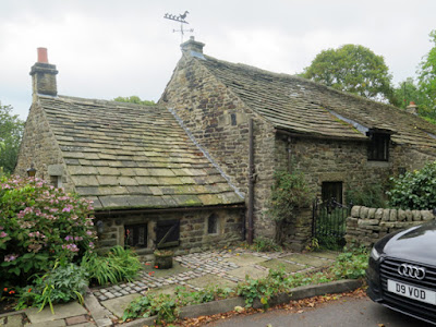
Next to the war memorial is Gilleyfield Farmhouse, which has a fine example of a stone flagstone roof. Dated at 1739, this is actually the last site on the trail and has some other interesting features, as I discovered later, but surprisingly it is not a listed building.
Stopping quickly at the village well to look at the much worn Crimea Memorial Stone, notable for the ripple marks in the large slab of sandstone as well as its historic value, I quickly walked along Vicarage Lane, where I was interested to see a series of old grindstones laid out on the verge.
Woodbine Cottages at the end of Vicarage Lane provide another good example of stone tile roofing and, although its C20 additions detract from its character, the simple mullioned windows are a reflection of its C17 origins.
Moving along to Watering Trough Green, I then cut down Devonshire Terrace Road and carried on up to Townhead Road, where I briefly looked at the various cottages listed on the trail – with Cromwell Cottage, dated 1686, being of most interest to me.
Returning back to the village via Drury Lane, a pair of 1930’s detached houses on Church Lane particularly interested me – even though they are not built out of stone. Over the years, I have seen very many houses from this period, with the vast majority being standardised in their design; however, with their front doors set on the corner and other individual features, I thought that they were quite unusual.
The Dore Heritage Trail finishes on Vicarage Lane, which contains Dore’s oldest building – Church Lane Farm. Dating back to the mid C17, this Grade II Listed building provides a further example of the use of stone tiles on a steeply pitching roof, with slightly projecting dormer windows to the main part of the house.
Passing the late Georgian Christ Church, which I had visited earlier in the day, I stopped briefly to photograph the walling next to its lych gate. Passers by would probably never take any notice of this but the irregularly coursed thinly bedded stone, with its strong iron colouration, provides a geologist with a good indication of the physical characteristics of the underlying bedrock.
At the end of a good walk, with half an hour to spare before my bus back to Sheffield arrived, I couldn't think of a better way to finish the Dore Hertage Trail than at the Devonshire Arms.
 |
| Thinly bedded sandstone to the churchyard wall on Church Lane |
At the end of a good walk, with half an hour to spare before my bus back to Sheffield arrived, I couldn't think of a better way to finish the Dore Hertage Trail than at the Devonshire Arms.
 |
| The Devonshire Arms |


No comments:
Post a Comment