 |
| An old quarry on the outskirts of Carr |
After a brief stop in Brookhouse to photograph its listed buildings, I continued my planned walk from Throapham to Maltby by following the public footpath up past Thurcroft Hall, where I hoped to see the cultivation terraces that are marked on the 1:25,000 Ordnance Survey map.
 |
| An Ordnance Survey map of the area around Brookhouse and Carr |
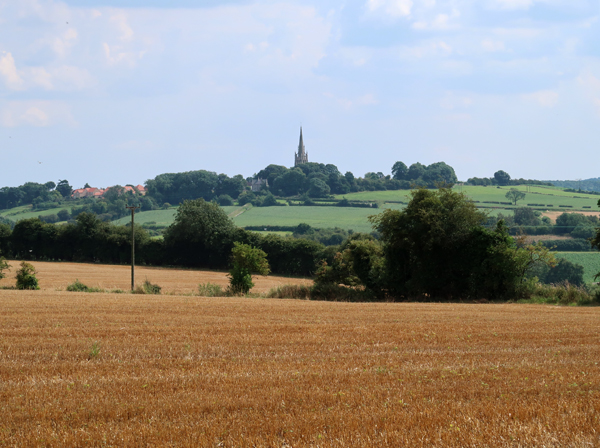
Looking on Google Map, I could clearly identify a series of parallel linear features that step down the south facing slope but, once standing on the ground, the lack of shadows that would otherwise highlight breaks in the topography makes these quite difficult to identify.
 |
| Cultivation terraces |
Although the listed buildings that I had identified here were inaccessible to the general public, I was very interested to see that an exposed wall of an old rendered farm building visible from the footpath is built out of red sandstone, which would not really be expected when limestone is readily available from the nearby Permian Cadeby Formation.
 |
| Red Carboniferous sandstone used for an outbuilding at Thurcroft Hall |
The building is on private land, so I could only take a photograph of it from a distance, but it looks to me like the Rotherham Red variety of the Mexborough Rock, which was quarried in a few places at Whiston, which is a few kilometres to the west; however, having discovered that the Wickersley Rock also produces some red sandstone, I would need to undertake further investigations to determine its provenance.
 |
| A view of All Saints church in Laughton-en-le-Morthen |
Continuing further up the footpath onto the plateau formed by the Cadeby Formation, I stopped a couple of times to take photos of All Saints church in Laughton-en-le-Morthen – which is quite visible on the skyline – and of the topography that I encountered earlier in my walk.
 |
| An old limestone quarry on the outskirts of Carr |
Walking along the side of a wheat field, which reaches to the edge of the limestone escarpment, I eventually found the public footpath and dropped down to discover a decent sized quarry, where a couple metres of yellowish massive limestone is overlain by a metre or so of flaggy beds.
 |
| Obliquely fractured limestone |
In places, the massive beds are highly fractured and sometimes this appears like it is the result of the use of black powder for quarrying, but there are several beds up to no more than 40 cm that could provide building stone of a decent quality, without resorting to such methods.
 |
| Massive beds of limestone with undercutting |
The reddening of parts of the quarry face are associated with fires, which are commonly seen in old quarries, but the general rubbish typically left by youths - consisting of beer bottles and cans, plastic water bottles and sometimes hypodermic needles and nitrous oxide canisters – were absent on this occasion.
 |
| A fire burnt exposure of dolomitic llimestone |
The sample that I obtained with my Estwing hammer from a massive bed is pale cream in colour, granular and has a relict oolitic texture and some very small shell fragments. Also, small black grains are scattered through the body of the stone, which are quite commonly found in the Cadeby Formation and are manganese oxides.
 |
| A sample of dolomitic limestone (21 mm diameter coin) |
I didn’t spend too long examining the various rock faces, but I didn’t see any obvious bands of red marl, like I had seen in the crags at Hooton Cliff and along the Don Gorge, but a fallen tree did have a very red clayey soil attached to its roots.
 |
| Red marl exposed in the roots of a fallen tree |
Descending the footpath to Ramper Lane and then carrying on round the right angle bend to Carr Lane, I just took a few general record photographs of the vernacular architecture – including a partial view of the Grade II Listed Low Farmhouse and a newly refurbished unlisted farm building – before continuing to Hooton Levitt.
 |
| Vernacular architecture in Carr |
No comments:
Post a Comment