 |
| An outcrop of Crawshaw Sandstone on Walkley Bank Road |
After straying from my usual practice of describing my various projects in chronological order - to report on further stone matching at St. Helen’s church in Treeton and the related talk to the Friends of Rotherham Archives on 5th November 2022 - I return to the first week of October in 2021.
 |
| A walk from Walkley to Hillsborough via Wadsley |
Having had a good exploration of the Parkgate Rock and the historic architecture and building stones around Halfway and Mosborough, the plan for my next day out was to visit the former Morley Street Board School and Malin Bridge Council School – and then walk to Wadsley and Hillsborough, where I would take more photographs for the British Listed Buildings website.
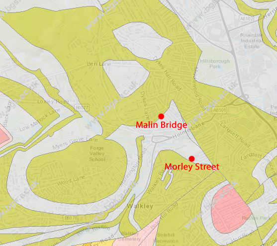
Alighting from the No. 52 bus on Walkley Road, I had another quick look at the Walkley Carnegie Library which, together with the nearby Bole Hill and Walkley Board Schools, is built with the uniformly buff coloured Crawshaw Sandstone from Bole Hill. Looking at the geological map for the area, my route to Wadsley – which I had not explored before - would pass over the Crawshaw Sandstone, Middle Band Rock and the Loxley Edge Rock.
 |
| Road setts made of Loxley Edge Rock |
Turning down onto Walkley Bank Road, I continued until I reach Elliottville Street, which has its original large sandstone road setts exposed. I noted that this coarse grained stone has marked variations in colour from grey to orange, which contrasts with the Crawshaw Sandstone used for Victorian terraced housing in the vicinity. It is very similar to the sandstone used for the Sheffield Royal Infirmary, which is believed to be built from the Loxley Edge Rock at Wadsley Common.
 |
| A retaining wall built on an outcrop of Crawshaw Sandstone |
A little further down Walkley Bank Road, the retaining wall on the east side of a small green space that was once occupied by a terrace of houses caught my eye, because it is set on a small outcrop of steeply dipping sandstone, which the geological map marks as Crawshaw Sandstone.
 |
| A detail of the outcrop of Crawshaw Sandstone |
On this occasion I didn’t have my Estwing hammer with me and, although I was able to get close to the outcrop and clearly see the low angle cross-bedding like that seen at the outcrops in Crookes back in February, I was unable to obtain a sample.
 |
| A detail of the road and pavement on Morley Street |
Making a mental note to come back another day, I continued down the road to Morley Street where, as with several other places that I had seen around Walkley, the slope of the land has been landscaped to accommodate the road, with a double stepped kerb of coarse grained Loxley Edge Rock dropping down to the adjoining path.
 |
| A kerb made of coarse grained Loxley Edge Rock |
Continuing down Morley Street, I stopped to take a photograph of the view across Malin Bridge and up to the high ground of Loxley Common, which is formed by the Loxley Edge Rock, before having a good look at the former Morley Street Council School – now Rivelin Primary School.
 |
| A view from Morley Street to Loxley Common |
No comments:
Post a Comment