 |
| Knowle Top Methodist Chapel |
Leaving Christ Church to continue my exploration of Stannington, I immediately stopped to have a look at the Lomas Hall (1955), where the three interesting relief sculptures on the front of an otherwise uniteresting building caught my eye as I was walking past.
The sculptures, depicting agricultural workers reaping wheat with a sickle, sowing seeds and working with a plough, are carved in volcanic green slate from the Borrowdale Volcanic Group in the English Lake District. I have made enquiries to find out who the artist was and the reason for the agricultural theme, but I have not had any reponse to date
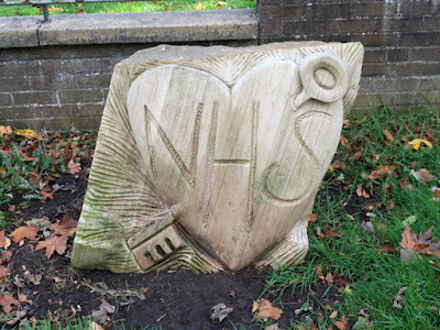
Walking down Uppergate, I stopped briefly to photograph a sculpture produced by a mystery artist, which is one of several that appeared around Sheffield at the height of the COVID-19 Pandemic, to celebrate the work of the NHS (National Health Service) - as I had also seen earlier in the year, when walking from the Rivelin Valley to Hillsborough.
At the junction of Uppergate and Stannington Road, I had a quick look at the Knowle Top Methodist Chapel, which has subsequently closed for worship and was put up for sale, with the bid put in by a local community group Action for Knowle Top rejected, for the reason that Charity Commission rules insisted that the highest bid be accepted.
Originally built in 1841, but reconstructed in 1878 by H.W. Lockwood in a very striking Neo-Romanesque style, the chapel and a single storey school (1866) to the rear have been recently placed on the Sheffield Local Heritage List.
It is not that easy to get a good impression of the colours and textures of the rock faced walling stone, which in places is severely blackened, but the relatively clean stone around the west entrance shows no sign of iron staining or Liesegang rings.
Its uniformity of colour is very similar to the Crawshaw Sandstone used for the vast majority of the Sheffield Board Schools, as recorded at the Hammerton Street Council School and, having made the assumption – based on quarries seen on old maps – that the Crawshaw Sandstone is the principal building stone used in Stannington, it is likely that the chapel is built with this too.
Having a quick look around its churchyard, I found the Commonwealth War Graves Commission headstone to Sapper J. Tattersall of the Royal Engineers, which looks like it has been made with the renowned Darley Dale sandstone from Derbyshire - only the second example of this stone that I had seen, after Wadsley parish church.
Looking from a distance at the adjoining Stannington Infant School (1910), although much of the stone is blackened, the general pattern of masonry is very similar to that seen in the early C20 board schools, such as Morley Street School, with pink Matlock stone used for the dressings and very probably Crawshaw Sandstone for the walling.
 |
| Matlock stone used for dressings at Stannington Infant School |
Returning to Stannington Road, I took a couple of photos of the Millennium 2000 sculpture outside Stannington Park, before continuing through the area known on old maps as Knowle Top, which is detached from the original village marked as Stannington - combining Nethergate and Uppergate – but now forms the shopping centre for the suburb.
 |
| The Millennium 2000 sculpture |
I passed by several sandstone houses that the Ordnance Survey maps show were built before 1851 and others that first appear on the 1894 edition, which was surveyed in 1890. The underlying geology here is the Middle Band Rock, but the geological memoir does not mention this as a source of building stone. Although a very small quarry is marked on the 1855 map, it is more likely that the stone came from the quarry in the Crawshaw Sandstone on High Riggs Road.
 |
| C19 houses on Stannington Road |
Continuing for a short distance, I then came to the Grade II Listed Pond Farmhouse, which I photographed for the British Listed Buildings website. Its exterior is built in stone that has been partly rendered, but this encases a late mediaeval timber cruck frame.
 |
| Pond Farmhouse |
The last place on my list to photograph for the day was the Stannington Cross, the base and stump of a mediaeval cross set at the junction of Stannington Road and Oldfield Road, which is thought to have marked the village boundary. It is made of a massive sandstone, described in the Historic England listing as gritstone, but I didn’t look at it very closely and just carried on down the hill until I reached Malin Bridge.


No comments:
Post a Comment