 |
| The datestone at the old Morthen Chapel |
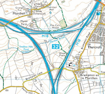
Continuing with my walk, having photographed the historic buildings of Thurcroft and Brampton-en-le-Morthen, I headed off along Wood Lane and under the bridge on the southbound motorway to find the public footpath to the hamlet of Morthen – one of the three places in Rotherham, along with Laughton-en-le Morthen, to take the name morthen from the Old Norse for ‘moorland assembly.’
Walking parallel to the motorway for a short distance, at the point where the path turns sharply and drops down into the valley formed by Morthen Brook, I stopped to take a few photographs of Morthen in the distance – where a red/brown ploughed field and the converted barn known as Oak Cottage on the horizon behind it were clearly visible.
Following the path down to Morthen Brook, I passed under another section of the M1/M18 motorway junction and headed up to Morthen where, after briefly stopping to look at the scarp slope of the unnamed Pennine Upper Coal Measures Formation (PUCMF) sandstone that I had just descended, I immediately came across lumps of reddened sandstone in the field next to the path which, looking at the field boundaries here, I thought might be related to an old wall.
Compared to the sample of sandstone collected at Second Lane in Wickersley, although similarly medium grained, it has a comparatively dull red colour that is provided by interstitial oxidised iron bearing minerals between the sand grains.
Looking at the geological map, I could see that I was on the edge of the Ackworth Rock, which I had not encountered before in Rotherham, but is described in the geological memoir as being thin and containing a lot of clay and shale. The piece I obtained from Brackenhill Quarries and other examples that I had seen, when undertaking research for a project at All Saints church in Pontefract, were grey/brown but had no red colouration.
Continuing along the path into the hamlet, most of which is set on relatively level ground formed by PUCMF siltstones and mudstones, the first building that I encountered was a small outbuilding built out of sandstone that has various shades of yellow and red - a characteristic of some of the Rotherham Red sandstone in the southern part of the borough.
The plum coloured blocks especially, as I had also seen at Wickersley and on Toad Lane in Brampton-en-le-Morthen seem to be more susceptible to cavernous decay and the cross-bedding is highlighted by differential weathering. Although I could not get close enough to observe the stones closely, the various buildings surrounding Lawns Farmhouse on York Lane appear to be built out of different sandstones, with some having red/yellow colour variation, while others or parts of them are mainly yellow.
The old Morthen Chapel (1885) on the opposite side of the road provides another example of how variable the colours and textures of the sandstones used in this part of Rotherham can be, which can make it difficult to select a matching stone to be used for repairs.
No. 2 York Lane, Holme Farm with its associated buildings and No. 4 Morthen Hall Lane all show the same colour variations as described above, to varying degrees, and I assume that the mostly yellow varieties have been obtained locally from quarries that have long since been infilled or turned into a plantation.
Morthen Hall Lane continues to the east and rises up a gentle escarpment formed by an unnamed PUCMF sandstone which, appearing as the first sandstone formation below the Dalton Rock, is very probably the same rock that was exploited at Wood Quarry in Brampton-en-le-Morthen.
Arriving at Oak Cottage, which is perched on the edge of the escarpment, I took a few quick photos of this and The Mews – the now converted stable block and coach house to the Grade II* Listed early C18 Morthen Hall - for the British Listed Buildings website.
Morthen Hall was built by John Carver, the rector of Whiston, and was the former home of the Athorpe and Middleton-Carver families. From a distance, the sandstone appears to be more uniform in colour than other buildings that I had seen, with a slight pink colouration to some of the generally yellowish stone.
Completing my task for the day by photographing the ha-ha, gates, gatepiers and front boundary wall to Morthen Hall, I set off towards Wickersley and soon came across a large open field, where the ploughed soil is very red. Looking at the geological map, this is underlain by the Dalton Rock and the 1854 Ordnance Survey map shows that the plantation is the site of an old quarry.
This is the nearest quarry to Morthen and could therefore have been the source for its stone, but the map also shows that Sheep Dike Lane at the edge of the field is marked as a bridle road and runs past the old Wood Quarry in Brampton-en-le-Morthen. I do not know when these quarries were established, but it raises the possibility that before the development of turnpike roads, packhorses could have been used to move the stone.


No comments:
Post a Comment