A couple of days after my brief look at the outcrop of Rotherham Red sandstone on Whitehill Lane in Brinsworth, Rotherham, my next day out was to Worrall, a small upland village 6.5 km to the north-west of Sheffield city centre, which is underlain by Crawshaw Sandstone that dips 4 degrees to the north-east and is brought into sharp contact with the younger Loxley Edge Rock by the Sheffield Fault.
Alighting from the No. 57a bus at the Haggstones Road/Kirk Edge Road stop, I went down to have a look at the area around the triangular green, which is formed at the junction of Worrall Road and Kirk Edge Road.
On the north side, a simple war memorial with a soldier carved in relief and an inscription sits between various planters, which had very attractive floral displays at the time of my visit, and alongside the wall is a series of troughs, similar kinds of which I had also encountered at Loxley, Stannington and Grenoside.
On the triangular green in the middle of the road, I came across one of several sculptures by Wood Nymph that mysteriously appeared overnight in several places around Sheffield, during the early phase of the COVID-19 Pandemic. Although I appreciate the sentiment, this very crude example appears to have been made without much thought or skill and, to my eyes, is ugly and doesn’t fit in with its surroundings.
Retracing my steps to Haggstones Road past the Blue Ball Inn, I turned up Towngate Road and passing various buildings, including the Independent Chapel (1878) and the old school house, I noted the sandstone used in these buildings was massive, coarse grained and very variable in colour, between muddy grey and orange, and was often mottled in appearance.
Continuing up Towngate Road, I stopped to have a food look at an old farm building on the right hand side, where the walling is composed of of massive, strongly cross-bedded sandstone blocks, with very large quoins.
The sandstone is very coarse grained and very similar in appearance to those that I had seen along Loxley Edge, in Wadsley and Malin Bridge, where the very coarse grained Loxley Edge Rock is predominantly used for the vernacular architecture.
Looking on the 1855 Ordnance Survey map, I can see 4 quarries within 1 km of the centre of the village and these are all located on the Loxley Edge Rock Looking closely at one block of massive cross-bedded sandstone, the grains are frequently at least 2mm in diameter and I think it highly probable that it comes from this rock formation.
I then went in search of three buildings that I wanted to photograph for the British Listed Buildings website, the first of which was the Grade II listed Fox House, a cruck frame building probably dating to the C17, which has been encased in later stonework.
After getting photographs of the elevations that I could see from the road, my next building was No. 64 Towngate Road, a plain building with a date of 1687 on the lintel to the front door. I just took a few quick snaps of each elevation, where the projecting moulded kneelers were its most interesting feature.
The adjacent No. 66 is of a similar late C17 date, with windows that have moulded surrounds but from which the mullions have been removed. As is common in C17 houses, it also has projecting moulded kneelers and is roofed with stone tiles.
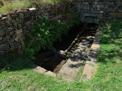
It only took me 20 minutes to have a very quick wander around the old core of the village and I then headed down the public footpath to Hagg Stones, where I encountered the Tun Gate well and washing trough, which was restored the year before by the Worrall Environment Group.
As with the various troughs and well heads, features such as this add great character to the upland villages of Sheffield, especially since they were often the only sources of drinking water for the villagers and perhaps the only place where workers in the coal mines and ganister pits of Worrall could clean themselves after a day’s work.
Continuing down the track, I finished the first leg of the day’s walk at Boggard Lane, where I stopped to photograph The Asplands (1769), which has a fine sundial attached to the front elevation, which is built in good quality ashlar with a batted finish.


No comments:
Post a Comment