 |
| No. 24 Pinfold Lane |
My day out to St. John’s church in Royston and St. Peter’s church in Felkirk ended by walking to Shafton, where I photographed a milepost for the British Listed Buildings Photo Challenge, before continuing along the Pontefract Road towards Cudworth until the next bus to Barnsley arrived.
A week later, I set off again on the bus from Treeton to Sheffield, where I caught one of the frequent trains to Doncaster, followed by the then hourly No. 22 bus to Tickhill, which I had used a few weeks earlier for my exploration of Wadworth and Loversall.
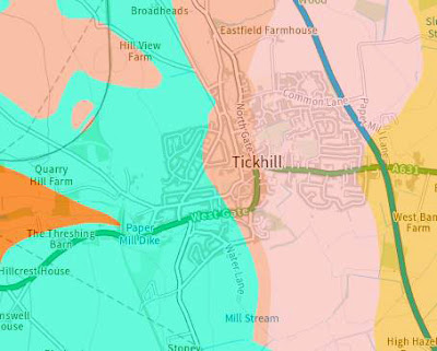
Starting on the Triassic Chester Formation at Doncaster Interchange, the A60 trunk road drops down to the Permian Brotherton Formation and continues south to Worksop over the older calcareous mudstone of the Permian Edlington Formation, which forms relatively low ground.
Continuing from Wadworth to Tickhill, I didn’t take much notice of the agricultural landscape around me but, having since referred to various British Geological Survey maps, I have learned that I also crossed the calcareous mudstone of the Permian Roxby Formation and the Triassic Lenton Sandstone – upon which Tickhill Castle is built.
Alighting from the bus at the West Gate/Worksop Road stop, I immediately set about my Photo Challenge for the day – to try and photograph 32 listed buildings - and also have a good look at the interior of St. Mary’s church, whose exterior I had quickly photographed in September 2021, when attending the delayed annual Sunday afternoon opening of Tickhill Castle.
First on my list were the Grade II Listed C17 gate piers and arch to the old Augustinian Friary which, according to Historic England, was founded c.1260 by John Clarel - a canon of Southwell - and dissolved in 1530.
I couldn’t get near to the Grade II* Listed Friary and Friary Close and took a few quick snaps of Friary Cottage (1688), before retracing my steps back to Worksop Road and then exploring Friars Lane, where I could only get a glimpse of one of the buildings at the friary..
The arch to the friary is built with massive dolomitic limestone that I presume to be from the Cadeby Formation, which outcrops less than 2 km away to the west, but much of the older boundary walling is built with thinly bedded limestone from the Brotherton Formation, which the 1854 Ordnance Survey map shows as being quarried in four places.
Although best suited for the production of lime, with lime kilns being shown at three of these quarries, this formation does have a minority of beds that achieve a height of up to approximately 200 mm, which makes it suitable for basic walling but not dressings and this can be seen at Rockhouse on Westgate, which has foundations of thinly bedded limestone.
The specimen I obtained has a bed thickness is cream coloured, finely crystalline, with a relict oolitic texture. The bed thickness is approximately 20 mm and one bedding plane has an abundance of reddened inclusions, some of which have elongated tube like structures that look organic, which are not obvious with the naked eye, and it also has fine grains of black manganese oxide disseminated throughout the body of the limestone.
The early C19 No. 24 Pinfold Lane, which has unusual pointed arch windows on the front elevation, is built with thinly bedded limestone, more massive blocks and some that are quite distinctly yellow stained, but I couldn't get close to examine the latter.
Making my way back to Westgate, I found the footpath that took me to Paper Mill Dike, immediately to the south of which is the Grade II Listed garden wall to the stuccoed early C19 Brook House, and from where I got a glimpse of the partly brick built garden house.


No comments:
Post a Comment