 |
| The spillway to Mill Dam passing beneath Lindrick |
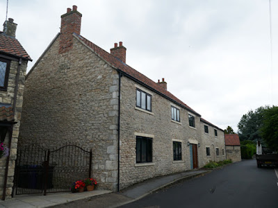
Continuing my exploration of Tickhill, the next building on my list to photograph for the British Listed Buildings Photo Challenge was Lindrick House and after taking a few photos of the rendered early C19 Brook House, I headed east along Lindrick and immediately stopped to photograph the refurbished Lindrick Farm House and attached farm building.
Looking at the current Google Street View of Lindrick, which was photographed in 2011, the west end was rendered and had no openings and the farm house to the east had its stonework marred by very thickly applied Portland cement ribbon pointing and the ground floor door and windows had a different configuration.
There is a strong contrast in colour between the massive quoins, which are pale cream and have probably brought in from the Cadeby Formation, and the yellowish limestone that is more thinly bedded and is probably locally quarried from the Brotherton Formation.
I didn’t stop to look closely at the stonework and carried on along Lindrick until I encountered another range of farm buildings, which appear on the 1854 Ordnance Survey (OS) map and have also been partially refurbished since the 2011 Google Street View was published.
The Grade II* Listed early C18 Lindrick House is another building which has rendered rubble walling with ashlar quoins and dressings, with the gate piers and garden wall providing further examples of contrasting limestone from the Cadeby Formation and Brotherton Formation.
After taking a quick look at Lindrick Cottage, at the eastern end of the farm complex mentioned above, I carried on along Lindrick and, when looking over the boundary wall, I was very surprised to see a moderately sized manmade channel, which I soon learned was the spillway from Mill Dam.
Just a few minutes earlier I had crossed Paper Mill Dike, which confluences with Denaby Wife Dike 2 km to the west on the Edlington Formation, before continuing along its natural course east towards Tickhill and then feeding Mill Dam, which is sited next to Tickhill Castle and its moat.
From Mill Dam, the spillway continues westward alongside Lindrick and then turns at a right angle to the south and disappears under the road, before emerging on Water Lane and, as the renamed Mill Stream, continues along another engineered route for more than 1 km before eventually joining up with the River Torne.
Along the course of the River Torne, which rises at Sandbeck Park and empties into the River Trent at Keadby, much of the land was waterlogged until 1628, when Cornelius Vermuyden was appointed to drain Hatfield Chase. Looking at the British Geological Survey map, the deposits of alluvium to the south of the castle show the extent of ancient flooding and a map of the dikes and drains shows that the area has been the subject of extensive water engineering.
I retraced my steps back to Lindrick and followed the spillway to the sluice at Mill Dam, which was originally built in the C11 to power the Crown Mill and also served the Grade II Listed Tickhill Mlil - sited at its southern end and marked on the 1854 OS map as a corn mill.
Tickhill Mill, which is now in residential use, dates back to the C13 and is the last of the town's four water mills to survive, but only C18 and C19 elements of the building still remain. These are built using locally quarried coursed rubble limestone for the walls, massive limestone from the Cadeby Formation for the quoins and dressings and red pantiles for the roofs.
The next building on my list to photograph was the early or mid C18 Grade II Listed Mill Farm House, which is built with similar materials to those seen at Tickhill Mill and contributes to this very attractive part of the Tickhill Conservation Area, without possessing any features of real architectural merit.
The same can probably be said about the C18 or early C19 Castle Farm Cottage which, along with the unlisted house named Roadside Barn, belongs to the group of buildings that is marked as Castle Farm on the 1854 OS map.
The last building to photograph in this part of Tickhill was the large two storied C18 or early C19 Barn in Castle Farmyard, accessed from a public footpath that I have since learned leads to more dikes and drains that eventually link back to Paper Mill Dike - which then joins up with the River Torne to the east of Tickhill.


No comments:
Post a Comment