 |
| A comemoration of the coal mining and rail manufacturing industries |
After photographing Quoit Green House, at the end of my walk from Green Lane to Quoit Green, I retraced my steps down Hallowes Lane and turned into Quoit Green and stopped to have a quick look at No. 14, which has been cleaned and reveals the characteristics of the Silkstone Rock.
This formation underlies most of central Sheffield and outcrops in the Sheffield Midland railway station cutting, but I have never knowingly seen this used as a building stone in the city. Although I had seen various historic buildings in Coal Aston, most were blackened to an extent and this partially obscures the orange iron staining of the sandstone.
On the corner of Quoit Green and Cross Lane, which are within the south-eastern part of the Dronfield Conservation Area, I was interested to see a very unassuming building, whose purpose is inscribed above the door in the word CONSTABULARY and has iron bars on the windows of the cells in the side extension.
It is built with planar bedded sandstone, which looks different to the typical Silkstone Rock, with dressings of massive pinkish gritstone – of a type that has been described as Matlock Stone, where used for a handful of Sheffield Board Schools.
Returning to Chesterfield Road, the next building on my British Listed Buildings Photo Challenge was Rose Hill on Princess Road, together with its boundary walls. The Derbyshire Historic Environment Record mentions that this early C17 Grade II Listed house was rebuilt in 1719 by the lead merchant Robert Greenwood, who took advantage of Dronfield being on the established trade route to the inland port of Bawtry.
The nearby Grade II* Chiverton House and its south-east and south-west outbuildings, like Rose Hill, is set in large grounds and I could only get glimpses of this C17 house, with alterations in 1712 and the C19 and the best view that I had was from the footbridge at Dronfield railway station.
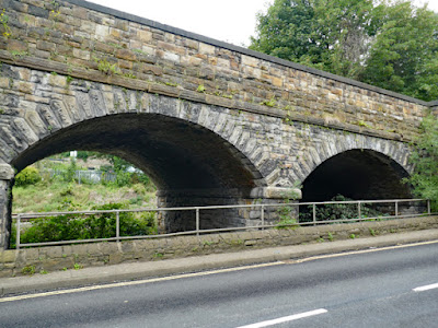
From here, I also had a good view of the Grade II Listed Lea Road Bridge, part of the complex multi-arch L-shaped masonry bridge structure built in 1870 for the Midland Railway Chesterfield to Sheffield line, to the designs of the railway company's Engineer-in-Chief J.S. Crossley.
On my previous visit to Dronfield, I alighted from the No. 43 bus from Sheffield at Sainsbury’s on Wreakes Lane and walked down High Street and Church Street to the Church of St. John the Baptist, where the character of this historic market town is essentially mediaeval.
I didn’t get further than the T-junction with Lea Road and therefore didn't see the post Industrial Revolution part of Dronfield - where foundries, forges, toolmakers and collieries, grew up alongside the River Dron, the old A61 road from Derby to Ripon and the railway line.
Continuing along Chesterfield Road past the ramped section of Lea Road Bridge, many of the stone built roadside houses that continue to Sheffield Road are now used for various commercial uses, but none of them are listed and I crossed over the road to take a closer look at a landscaped green space that is set next to the railway line.
The Millstone Grit archway here once formed the entrance to a foundry established in 1790 by Edward Lucas and Son Ltd. According to the commemorative plaque, Edward Lucas patented (1804) a method of producing malleable iron castings that was based on his work at this foundry.


No comments:
Post a Comment