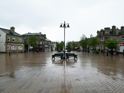
Including the time when I had to shelter from the very heavy rain, I spent less than 20 minutes looking at the historic architecture around Market Place in Ossett and then went to find the first of the 4 buildings that were on my British Listed Buildings Photo Challenge.
The former rag warehouse of the premises of Edward Clay and Son, who manufactured shoddy and mungo and still produce mainly felt, was built in the early to mid C19 but I just took a single photograph and headed along Ventnor Way back towards the town centre.
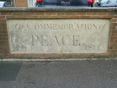
In the boundary wall of the King’s Way Methodist Church is a limestone plaque, which commemorates the end of the Napoleonic Wars and was was originally set in the Church of England day and Sunday school, which was demolished to make way for Ventnor Way.
After taking a photo of the K6 telephone kiosk on Dale Street, I had another quick look at Market Place and the area around the town hall, where many of the Victorian buildings to the north of it – including mills and rag warehouses – were demolished and the area redeveloped in the second half of the C20 with various nondescript buildings.
Making my way to Church Street, I immediately noticed the United Methodist Free Church (1857) on Dale Street, which has been converted into flats. As with various buildings that I had seen in Ossett and in Horbury, I thought that this would be listed and it does make me wonder what criteria Historic England and ultimately the Secretary of State apply when selecting listed buildings.
Continuing along Church Street, the Holy Trinity C of E Primary School, which first appears on the 1894 Ordnance Survey (OS) map, looks typical of the board schools that were built following the Elementary Education Act of 1870.
I just took a few general record photos, which show that it is built in local sandstone that is probably quarried from the Horbury Rock although, as mentioned in my last post, the Thornhill Rock was quarried not far away.
The former Northfield Mill (1888), now apartments, is built with a similar sandstone but again I only took a couple of photos before continuing to the Grade II* Listed Holy Trinity church (1865) by W.H. Crossland, a Huddersfield born architect who was a pupil of Sir George Gilbert Scott.
The church was not open and I spent most of my time looking around the churchyard and trying to get the very tall spire in my camera shots from a distance and, except for a quick look at the ornate surrounds to the west door, I didn’t get close enough to have a good look at the stonework.
My next stop was the Grade II Listed mid C19 Springstone House, which is built with coursed local sandstone walling, ashlar dressings and a Welsh slate roof. I just took a single photograph and made my way along Dewsbury Road, where there are a couple of old brick built mills of no great architectural merit.
Turning into Dale Street, I headed back towards the centre of Ossett and passed several sandstone built houses, which included modest detached villas and short terraces. The 1854 OS map marks several rows of tenters, used for stretching and drying cloth, at the back of the buildings at the southern end of the road, which shows that commercial and residential areas were not yet separated.
Returning to Market Place, I carried on down Bank Street to Illingworth Street, where some of the Victorian buildings still remain, but a car park occupies a space where some have been demolished. These include the Temperance Hall (1888), which is now the New Spring Church and a rag warehouse, used as a children’s play centre and a venue for learning martial arts.
Turning onto Prospect Road and starting off on my walk back to Horbury, I quickly stopped to look at section of rock-faced walling, where the lowest courses have weathered to reveal a body of grey sandstone, which contrasts strongly to the orange coloured weathered stone.
This looks like another use of the Horbury Rock, as also seen at the former Mount Zion Primitive Methodist Church (1863) on Queen Street, which has well squared and coursed walling with a broached finish and ashlar dressings.
Carrying on down the hill to The Green, I stopped briefly to look at the blue plaque dedicated to the philosopher Hannah Pickard, which is attached to the large detached house on the corner of Southdale Road, Green Mount.
Further down the hill is the Grade II Listed Christ Church, which was not part of my Photo Challenge. Looking at it it from a distance, it didn't appear to have any features and I just took a single photo from a distance and continued down to Sowood Road.
Sowood Farmhouse, which has C19 alterations that obscure its actual date of 1689, was the last building on my Photo Challenge. With the farmhouse being set at right angles to road and the front elevation obscured by a high garden hedge, I just took the best photo that I could and then headed off to find the footpath that would take me back to Horbury.


No comments:
Post a Comment