Monday, 23 November 2020

70 Acre Hill and High Hazels Park


An artificial pond on 70 Acre Hill

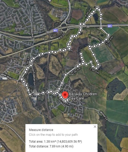
Following the COVID-19 lockdown instructions to go out only for essential exercise and shopping, my third trip to explore the geology around Treeton involved a short bus journey to Poplar Way, from where I headed north under the Sheffield Parkway to the 70 Acre Hill local wildlife site.

Gorse on 70 Acre Hill

As with Treeton Dyke and the land around Spa Farm and the River Rother, I had walked around this area many years ago and didn’t encounter any rock outcrops, but I remember the impressive views from the top of 70 Acre Hill, which is actually a landscaped tip of colliery waste.

Like at Treeton and nearby Catcliffe, various coal mines once operated in the area and the now disused Sheffield City Airport was built on the site of a large opencast mine, which was closed and infilled before I moved to Rotherham.
 
Views towards Rotherham
 
The path from the Sheffield Parkway to 70 Acre Hill passes around Tinsley Park Golf Course and at the time of my visit, the ubiquitous gorse bushes were in full bloom; however, I stopped only to look at the views towards Rotherham, where the Mexborough Rock forms the high ground.
 
A recreational area on 70 Acre Hill

Wandering randomly around various pathways, I encountered a few artificial ponds and a small recreation area, where there is a concrete sculpture, and then headed downhill to High Hazels Park, which I had never visited before.
 
An artificial pond

At its centre is the mid C19 High Hazels House, in the Italianate style, whicht is now the home of Tinsley Park Golf Club. It is notable mainly for the use of Permian dolomitic limestone which, although a very common building stone in Rotherham and Doncaster where the Cadeby Formation outcrops, I had not seen before in Sheffield - except for the chancel at St. James' church in Norton.
 
High Hazels House

On one corner of the house, a bright red patch on the limestone can be clearly seen from a distance and, looking closer, this reddening is the result of a fire that must once have been lit right next to the wall.
 
Fire damage at High Hazels House

I have seen this oxidation of the iron bearing minerals in several old buildings and ruins built out of dolomitic limestone, where there has been a fire, but the intensity of the heat here has been such that it has shattered the stonework.
 
A view across Tinsley Park Golf Course
 
Various modern sculptures are dotted around the park, as I have seen before in several parks in Sheffield, and I took a few photographs of these before heading across the empty golf course on the way back towards Poplar Way and Morrisons supermarket at Catcliffe.
 
A view of Treeon from Poplar Way

I didn’t see any rock exposures but, having walked for 6.75 km, it was good exercise and I now have a better appreciation of the varied topography formed by the Pennine Middle Coal Measures Formation strata in this part of South Yorkshire, as well the coal mining history.

A walk around 70 Acre Hill
 

Saturday, 21 November 2020

From Spa Farm to the River Rother


Wetlands at Long Lane

Continuing my exploration of the geology and historic buildings around Treeton during the COVID-19 lockdown, after taking a few photographs of the Mexborough Rock that forms the high ground beyond Ulley Brook, I had a quick look at Spa Farm.
 
A view of the Mexborough Rock beyond Ulley Brook
 
A chalybeate spring here was once exploited for therapeutic purposes in the 1660’s and a couple of farm buildings are listed, but I only stopped long enough to note the mottled red/yellow colouration of some of the Rotherham Red sandstone before making my way down to Long Lane.

Various buildings at Spa Farm

The escarpment of the Mexborough Rock and the line of the Spa Fault can be clearly seen from here and, continuing along Long Lane under the M1 motorway towards Whiston - passing by a lot of rubbish on the way - I went to investigate an area of permanent wetlands that I had seen many times when driving by.

A view to Spa Farm from Long Lane

Looking at a geological map, the area between Treeton, Catcliffe and Whiston is marked by an extensive spread of alluvial sediments that have been deposited by the River Rother and its tributaries - Ulley Brook and Whiston Brook – and the whole area was turned into a great lake during the floods of 2007.
 
The natural landscape here has been changed so much by efforts to manage the flow of water, with various embankments and drainage ditches being clearly marked on Ordnance Survey maps that date back to the mid C19.

Arriving at a break in the hedgerow on Long Lane, I followed the footpath to the wetlands and quickly walked around its edge, from where I could see various species of water loving plants that would be of interest to botanists and ecologists.
 
The wetlands at Long Lane

Returning to Long Lane, I had a look at the Rotherham Red sandstone bridge that crosses Whiston Brook, which has a surprisingly small arch through which the water flows, and then followed the brook for a short distance before heading along the path towards the River Rother.
 
Views of Whiston Brook
 
Unknown to me at the time, the path runs past a moated scheduled ancient monument known as Blue Man’s Bower, which I had been aware of  ever since living in Treeton but had never known its precise location. Stopping only to photograph the escarpment of the Mexborough Rock in the distance, which I had encountered earlier on my walk, I soon arrived at the river.
 
A ridge of Mexborough Rock in the distance

Starting my walk back to Treeton, the path next to the River Rother runs under the M1 and continues intermittently along embankments and, with the riverbanks here being completely bare and only seeing a couple of swans, I hurried on towards Catcliffe.
 
Views of the River Rother
 
Looking back towards Bole Hill Plantation, which covers the spur of Mexborough Rock that was once quarried for Rotherham Red sandstone, the soil on the lower slopes above the floodplain is characteristically red.
 
Bole Hill Plantation

Beyond Catcliffe railway bridge, which now only takes freight traffic, the path carries on along past a landscaped tip of waste from Treeton Colliery and ends at the disused railway viaduct, where the renowned Staffordshire blue engineering bricks have been used in its construction.
 
Railway engineering along the River Rother

Towards the end of my walk, I took a path that I had never used before, which runs on an embankment alongside the River Rother behind Catcliffe Flash, an area affected by coal mining subsidence that is now a nature reserve popular with birdwatchers.
 
A view across Catcliffe Flash

Stopping to photograph a feature in the riverbank at the edge of the Waverley Estate, which at a distance I thought might be an outcrop of the Pennine Middle Coal Measures Formation, I walked along another embankment to Treeton Lane, from which I had a good view of the new building that has been erected on the former site of Mill House.
 
Miscellaneous views
 
I finished my walk by carrying on up Mill Lane over the railway bridge to Station Road, which then winds up the escarpment of Treeton Rock to the junction with Front Street, where I turned right and continued along Wood Lane until I finally got home.
 
An exploration of the Spa Fault and the River Rother
 

Saturday, 14 November 2020

A Walk to Spa Farm


An escarpment of Mexborough Rock at Spa Farm

Starting my exploration of the Mexborough Rock in Treeton at my house on Wood Lane, which is one of a terrace built in Rotherham Red sandstone for employees of the colliery, I walked along Front Street past St. Helen’s church, which is at the centre of Treeton Conservation Area, until I reached the T-junction with Station Road and Well Lane.
 
My Rotherham Red sandstone house

To the left, Station Road winds down the escarpment of Treeton Rock but I instead turned right into Well Lane, which runs down the dip slope of this geological formation and the overlying Middle Pennine Coal Measures Formation strata, and carried on down until I reached a shallow vale, where the railway line from Treeton Colliery once crossed.

Views down Well Lane

Before the River Rother was diverted and coal mining and associated tipping completely changed the landscape around the village, old Ordnance Survey maps mark wells and pumps in several places on this road, but no signs of these are now visible and without much of interest to see here, I quickly walked up Bole Hill.
 
A map of Treeton in 1850

Passing a row of Rotherham Red sandstone terraced and semi-detached houses, which were built at the end of the C19, I stopped to quickly photograph a house dating to 1655, which has some interesting architectural details – including a miniature canted oriel-bay-window and an original stone tile roof.

A C17 house on Bole Hill

At the end of the village, just past the row of houses that turn at a right angle to Bole Hill, I followed the public footpath that heads straight up across the Mexborough Rock ridge and which, I have subsequently learned, is believed to be part of a Roman road that ran from Navio to Littlebrough – connecting the lead mines in Derbyshire to the River Trent.

The public footpath to Spa Farm

This path is also used by farm vehicles and, except to take few photographs of the landscape – which includes several examples of scarp and vale topography - I just made my way up to the top of the hill without stopping.
 
A view towards Treeton

Apart from taking a diversion from the path, to see if I could see any evidence of the old quarry from the top of Bole Hill Plantation – and finding only a fireplace made of fragments of Rotherham Red sandstone and a brick from one of the terraced houses that once existed next to Long Lane - I carried on along the path towards Spa Farm.
 
A fireplace
 
From conversations with friends in the village, I was aware that flint tools had been made in various places around Treeton and that other archaeological finds had been made in the area, but I didn’t notice anything in the ploughed land as I walked past.

The stile overlooking Spa Farm

As a geologist, I was more interested in the steep escarpment that becomes immediately apparently, when the path turns at 90 degrees before crossing a stile and descending steeply at an angle to Spa Farm.
 
A general view of Spa Farm

This distinctive topographical feature relates to the Spa Fault, one of a handful of large faults marked on the geological map of the Sheffield region and which is marked immediately to the north-west of the group of buildings that are found here.
 

Thursday, 12 November 2020

The Mexborough Rock in Treeton


Canklow Woods and the Duke of Norfolk Estate

When I wake up in the morning, I draw back the curtains to see a landscape that is dominated by a geological formation known as the Mexborough Rock, which “crops out over considerable areas, and forms pleasant, hilly country around Whiston, Ulley, Anston and Harthill” – as described in the Geological Survey of Great Britain memoir.
 
 A view of the Mexborough Rock

Looking out to the north-east, a ridge of this rock forms Spa Hill and Burnt Wood and, at its north-western end, Bole Hill Plantation now covers the old quarry that once supplied “Rotherham Red” sandstone, of which most of the historic buildings in Treeton have been built. 

The geology around Treeton

The lower slopes are obscured by a landscaped mound of red shale waste from Treeton Colliery, whose pithead and railway marshalling yard once occupied the land that is now covered by the Beaumont Park housing estate; however, the upper slopes comprise ploughed agricultural land, where the soil is conspicuously red. 

A view towards Burnt Wood

In the distance, to the north, I can see the escarpment that Moorgate follows from Rotherham town centre to the Bawtry Road and the break between the ancient woodlands at Canklow Woods and the Duke of Norfolk Estate is clearly visible. 
 
A view of Bole Hill Plantation

For my second walk under the COVID-19 lockdown in March 2019, following my exploration of Treeton Dyke - which didn’t add much to my existing knowledge of the geology of the area - it seemed obvious to further investigate the Mexborough Rock in Treeton.
 
A general view to the north


Monday, 2 November 2020

A Walk Around Treeton Dyke


Treeton Dyke

With the UK Government COVID-19 lockdown taking effect in March 2020, which limited me to go out only to buy food, take no more than an hour’s outdoor exercise and use public transport only as an absolute necessity, my further exploration of the geology, mediaeval churches and historic buildings of South Yorkshire and the surrounding counties came to an abrupt halt.

Covid-19 Alert Tier 3

Knowing that much of the area within walking distance from Treeton has been despoiled at one time or another by the coal mining industry, I did wonder how I would keep myself physically and mentally active – and find subject matter for my Language of Stone Blog.
 
The oldest part of Treeton, around St. Helen’s church, stands on a distinctive escarpment of Treeton Rock – now just recorded by the BGS as an unnamed part of the Pennine Middle Coal Measures Formation - which runs SSE to Hail Mary Hill Wood and Falconer Wood and overlooks the River Rother to the west, whose course has been diverted to enable the extraction of coal.

The original course of the River Rother

Standing on the boundary wall at the west end of St. Helen’s churchyard, there is now a clear view towards St. Mary’s church in Handsworth, whose steeple can be just about be made out on the skyline but, when I first moved to Treeton in 1997, this view was obscured by a vast mound of waste from the Orgreave Opencast Coal Mine – which itself occupied the former site of the Orgreave Coking Works.

The view to St. Mary's church in Handsworth

Prompted by a request to take some photographs of flowering blackthorn, by an elderly friend who had been ordered to shelter at home for the foreseeable future, my first walk entailed a walk around Treeton Dyke, which occupies a former meandering course of the River Rother that is now used for water sports and angling and recreation.

A walk around Treeton Dyke

Following the track down from Wood Lane, which is adjacent to the strongly contested Jones Homes development site and is further blighted by fly tipping, a path continues into Hail Mary Hill Wood and follows the course of a small stream, which occupies a distinct alluvium filled v-shaped feature that is clearly marked on the geological map.
 
On the way to Treeton Dyke

Carrying on down this path down to Treeton Dyke, the Treeton Rock forms a distinct spur to the south but there are no rock outcrops to be seen and the most distinctive feature here is an area of marshland where osiers and other wetland species flourish.
 
Views of the Treeton Rock escarpment
 
Continuing along the path that runs down towards the hamlet of Fence, which was built to accommodate the workers at the nearby colliery, I then headed back towards Treeton, passing land to the west of Treeton Dyke, which consists of waste products from Forgemasters.

A block of ripple marked sandstone

The only point of geological interest here are large blocks of ripple marked sandstone, which deter trail bikes, and from here I made my way back to Treeton along a path that skirts the site of an old quarry, which once supplied yellow/brown iron banded sandstone for the village. Before heading home, I stopped to take a couple of the Waverley Estate, which brings back memories of the song Little Boxes.
 
Houses on the Waverley Estate