Tuesday, 6 February 2024

All Saints Churchyard in Hooton Pagnell

 
The lychgate

Having spent just over an hour briefly looking at All Saints church in Hooton Pagnell, since alighting from the Stagecoach No. 203 bus from Doncaster, I had an hour and 20 minutes to explore the rest of the village – to photograph its listed buildings and have another look at its geology before the next bus to Thurnscoe and Goldthorpe arrived. 
 
The cross base and shaft

The first of these was the Grade II Listed limestone base of a cross, of mediaeval date, with a later shaft, which is located a few metres south of the porch. The shaft originally formed part of a sundial, but the dial and gnomon are now missing.
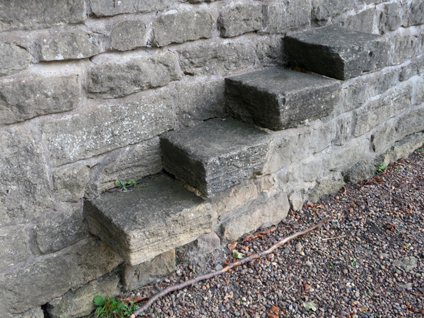
 
Horse mounting steps in the churchyard wall
 
Descending the steps to the B6422 road, I had a quick look at the cantilevered blocks of unknown date that have been set into the retaining wall of the churchyard, instead of the usual freestanding horse mounting block, before having a quick wander around the churchyard. 
 
Chest tombs in the churchyard
 
Although there is a Commonwealth War Graves Commission headstone here, which I wasn’t aware of and didn’t see at the time, I just took a few quick snaps of some of the chest tombs, which date back to the C18, where most comprise an inscribed slab of Coal Measures sandstone is laid on side panels that are made out of local dolomitic limestone from the Cadeby Formation. 
 
Weathered dolomitic limestone panels to a chest tomb
 
I didn’t spend any time looking at the fabric of church in any detail, but I certainly didn’t notice any areas where there had been scouring or cavernous decay. I was therefore surprised to see that on at least two chest tombs, parts of the side panels have been completely weathered away, leaving the sandstone slab precariously perched. 
 
Weathered dolomitic limestone panels to a chest tomb

Since 1703, the adjacent Hooton Pagnell Hall has been owned by the descendants of Patience Warde – the Warde- Aldam and Warde-Norbury families - and several monuments to various family members are laid out closely together in the southern part of the churchyard. 
 
The memorial to Julia Warde-Aldam

Julia Warde-Aldam, who is commemorated with a crucifix in the style of those erected by Viscount Halifax in nearby Hickleton, made quite radical changes to the hall and has been described as "a flamboyant benefactor with a fondness for seances". 
 
Various tombs of the descendants of Patience Warde

Other members of the family, such as Mary Betty, Alistair George and William George Anthony Warde-Norbury have simple raised inclined slabs, with a Latin cross for decoration, but other members of the family are buried in chest tombs.
 
Tooled limestone blocks in the churchyard

Next to the boundary wall, a couple of squared blocks of yellowish limestone - one adorned with a cross – look like they are probably masonry from the church. I had recently seen a salvaged window head from St. Wilfrid’s church in Hickleton, in the new Doncaster museum, but these stones aren’t documented and it is quite likely that very few people have noticed them.
 
A memorial to Rev. Godfrey Wright
 
I took a few photos of the tomb of Rev. Godfrey Wright, who was an owner of a considerable amount of land in Yorkshire, and also the tomb of Thomas Selwood and his wife Catherine, who was the sister of Patience Warde.
 
The tomb of Thomas Selwood and his wife Catherine
 
Before leaving the churchyard to go and investigate the rest of the historic architecture in the village, I took another quick snap of the lychgate, which is another contribution by Julia Warde-Aldam to Hooton Pagnell.
 
The lychgate
 

All Saints Church in Hooton Pagnell III

 
A view from the north aisle

Perhaps I was just a bit disorientated by entering the church via the priest’s door and starting in the chancel instead of the nave, as usual, but for some reason my method of systematic method of photographing churches got out of sync and the only view of the west tower is when standing in the chancel and looking west along the nave. 
 
A view from the chancel to the tower arch
 
The Corpus of Romanesque Sculpture in Britain and Ireland (CRSBI) record the details of the construction of the tower arch much better than me, but I did manage to have a quick look at the masonry inside the tower, which has the same pattern of rubble masonry that I had seen in the nave and chancel. which is considered to be a C14 reconstruction of the original Norman arch. 
 
A view of the west side of the tower arch
 
When first approaching All Saints church up the steps from the B6422 road, although I wasn’t aware of this at the time, the C14 angle buttress on the south-west corner of the tower was built at the same time as a spiral staircase to the upper stages of the tower, according to Peter Ryder’s church plan in the Saxon Churches of South Yorkshire. 
 
The entrance to the spiral staircase in the tower
 
In the area known in the church guide as the tower room there are two medieval grave slab set against the wall, one of which has a plain Latin cross - given a late C11 or C12 date by Ryder - and the other has an elaborate floriated cross, with one side incised with a sword entwined by a serpent and on the other a book. 
 
Grave slabs in the tower room
 
The north arcade is dated 1175-1200 by Pevsner and described as having two bays, a big circular pier with waterleaf decoration to the capital and an octagonal abacus. CRSBI and Historic England both date it as C13, with the latter drawing attention to the shape of its arches. 
 
The north arcade
 
This is a feature that is usually associated from the change from Romanesque to Early English Gothic style architecture but, with the tables and chairs used for the coffee morning occupying a good proportion of the north aisle, I just took a few quick snaps of the south side of the arcade. 
 
Views of the north arcade
 
I managed to take a couple of photos of the crocketted capital from different angles but didn’t spend any more time looking at the north aisle and moved on to its east and the Stotfold Chapel, which the church guide says was added in the C11. 
 
The crocketted capital in the north arcade
 
In the Comments/Opinions section of their report on All Saints church, however, CRSBI makes reference to the following: ‘Hamilton Thompson (1909), 126-7, thinks the N chapel was added to the early C12 chancel at about the same time as the N aisle was added to the nave, that is, ‘at a not very certain date… towards the end of the twelfth century’. 
 
The west side of the arch to the Stotfold Chapel
 
Ryder’s church plan assigns the base of the arch to the C15, which would account for the distinctly pointed arch, but Pevsner makes no mention of this – unless it is the unspecified arch to the north chapel that he just describes as difficult to assign a date to. 
 
A  view west in the Stotfold Chapel
 
In the walling above the pointed arch, there is a section of masonry that look like the voussoirs to an arch, for which I have not read any explanation and, once inside the Stotfold Chapel, this can still be clearly seen. Having finished my brief exploration of the interior, I stopped briefly to photograph the Norman font, which came from an unnamed church in 1900 and has been reworked, before heading off to find Hooton Pagnell’s listed buildings. 
 
The font
 

Saturday, 3 February 2024

All Saints Church in Hooton Pagnell II

 
A view from the chancel along the nave to the tower arch

After making the most of the sunny conditions at Hooton Pagnell, to quickly photograph the exterior of All Saints church, I took a couple of photos of the locked south door, where I didn’t notice any of the fine decorative detail that has been highlighted by the Corpus for Romanesque Sculpture in Britain and Ireland (CRSBI). 
 
The south door
 
Entering the church by the priest’s door in the chancel, I introduced myself to the churchwarden, Ann Macdonald, with whom I had been liaising about my planned trip and obtained a copy of the church guide – produced by the now defunct Heritage Inspired initiative and like very many others that I have collected during my travels around South Yorkshire. 
 
The All Saints church guide
 
With Ann leaving me to get on with my work, I just took a set of general photographs of the east end of the chancel, without stepping over into the sanctuary to look closely at the masonry detailing around the large east window, which Peter Ryder’s church plan in Saxon Churches of South Yorkshire shows to be from the Victorian restoration in 1876, by J.L. Pearson, or the C13 lancet windows to the east end. 
 
A few views of the chancel

Historic England dates the round arch from the chancel to the Stotfold Chapel to the C15, as does Ryder, who dates the north-east corner of the church plan – now occupied by the vestry and inaccessible – as being from this period. Pevsner says that it is difficult to assign a date to the N. chapel arch, but he doesn’t specify if this is the round arch from the chancel or the pointed arch from the north aisle.
 
The arch between the chancel and Stotfold chapel

Turning to look at the west end of the chancel, with its C11 rubble walling that incorporates the chancel arch and extends further into the nave and to the tower, there is a very great difference between this and the squared and coursed masonry used for the later C12 east end. 
 
The west end of the chancel and the chancel arch
 
Ryder’s church plan shows the surrounds of the priest’s door and the reveals of the west window as being restored in 1876, but I just took a few photos to record the very plain east chancel arch and the surrounding walling, which includes small sections of herringbone masonry. 
 
The chancel arch
 
Moving into the nave and turning round to look at the west side of the arch, Historic England describes this as having shafts and roll-moulded voussoirs on the west side and carved imposts with cable mould beneath lozenges, but I didn’t look closely at these. 
 
A view of the chancel arch from the nave
 
I didn’t spend any time looking at the physical characteristics of the original C11 walling, with its windows restored in 1876, or for the presence of herringbone masonry, but I could quite clearly see the moulded shafts to the windows when walking down to the tower.
 
The south wall of the nave


Friday, 2 February 2024

All Saints Church in Hooton Pagnell I

 
The tower of All Saints church

Having undertaken more preparation for my travel to Hooton Pagnell than anywhere else, to take into account the irregular nature of the No. 203 bus service, which runs from Doncaster to Wombwell, I set off early on 24th August 2022 with a packed lunch prepared, Neither of the First Mainline No. 73 or X54, which is now run by TM Travel, buses turned up in Treeton and my day out was stopped dead in its tracks.
 
The steps leading up to All Saints' churchyard

Much to my great annoyance, the same thing happened two weeks later, and I had to wait until Wednesday 21st September, after visits to Ault Hucknall, Eyam, Wragby and Nostell Priory, before I was finally able to attend a coffee morning at All Saints church. Alighting from the bus outside the church, the small flight of steps up to the churchyard provides an immediate reminder that Hooton Pagnell is sited on the edge of the Permian Magnesian Limestone escarpment. 
 
My first sight of the church was the lower part of the west tower, with the porch of unknown mediaeval date beyond, which sources such as Pevsner, Historic England and the Corpus for Romanesque Sculpture in Britain and Ireland date as late C11 and Peter Ryder included it in the Saxon Churches of South Yorkshire. 
 
A view east along the south elevation
 
From this viewpoint, I could not see the junction between the rubble masonry in the tower and the nave and the chancel beyond, but these authorities agree that they form a single phase of building. The Domesday Book does not record a church but, as I later discovered from the church guide, in 1089 a church was granted by Ralph Paganel to the Priory of the Holy Trinity in York. 
 
C11 masonry on the west elevation of the tower
 
Moving clockwise around the tower, the lowest stage has some herringbone masonry, which is often considered to be the mark of a late Anglo-Saxon or transitional post Norman Conquest style and is shown Ryder’s church plan as C11 masonry, along with the nave and the chancel.
 
The plan in Saxon Churches in South Yorkshire by Peter Ryder
 
Looking up at the tower, without the string course seen on the south elevation, the rubble masonry passes upwards into large ashlar blocks for the upper stages, which were added in the C14 together with a diagonal buttress, but the window was added by John Loughbotough Pearson during the restoration of 1876. 
 
A view up the west elevation of the tower
 
Pearson was not known for being sensitive to the mediaeval fabric of the churches that he worked on and the north aisle, with its 3-light square headed windows, was rebuilt during this ‘restoration’. I didn’t look at the dolomitic limestone masonry closely, but the light buff coloured stone and the yellow sandy varieties are quite obvious. 

The north elevation

Whilst in the north-east corner of the churchyard, I took advantage of its main entrance, with its lychgate, to take a very quick diversion to look at some of the unlisted houses in the vicinity, before returning to the church to briefly inspect its south elevation. 
 
The south elevation

From a distance, it is isn’t that easy to distinguish the change in the masonry style, from Norman to Early English, when the chancel was extended during the C13 but, when getting closer, the line of quoins that mark the end of the Norman chancel is quite clear. 
 
Masonry on the south wall of the chancel
 
A drawing of an old painting of the church, before Pearson’s restoration, is included in the Saxon Churches of South Yorkshire, which shows just how much the south elevation of the nave, in particular has been changed – with two Gothic arched windows, designed with Y-tracery, replacing a variety of square headed windows. 
 
All Saints church before the 1876 restoration
 
Further examples of herringbone masonry can be seen in the rubble fabric that forms the south elevation of the C11 chancel but, being aware that time was moving on, I didn’t study it in any detail and just took a few general record photographs.
 
Herringbone masonry
 
Before entering the church, I also took a couple of quick snaps of the C14 gargoyles on the tower which, along with a very weathered headstop, were the only decorative elements that I  had seen when quickly walking around its exterior.
 
Gargoyles on the tower
 

A Trip to Hooton Pagnell by Bus & Train

 
Treeton to Hooton Pagnell by car

Starting at St. Wilfred’s church in Hickleton on 20th August, followed by St. John the Baptist at Ault Hucknall and St. Michael and Our Lady at Wragby, on the first and second weekends of the 2022 Heritage Open Days festival respectively, in September, I successfully undertook journeys by public transport that involved three separate journeys each way, along with St. Lawrence’s church in Eyam, which I could reach using the 2 hourly No. 65 bus service from Sheffield. 
 
Saxon Churches in South Yorkshire
 
During this period, I also planned to visit the Grade I Listed All Saints church in Hooton Pagnell, which is included in the Saxon Churches in South Yorkshire by Peter Ryder. I had wanted to visit this church for a long time but, as with so many mediaeval churches nowadays, it is only opened for services and also for a coffee morning every Wednesday between 10:00 and 12:00. 
 
South Yorkshire RIGS Groups events
 
Within Hooton Pagnell Conservation Area, there are 29 listed buildings, many of which I wanted to photograph for the British Listed Buildings website, as well as a spectacular example of a bryozoan reef that was included in one of the field trips – led by the late Denys Smith - that the South Yorkshire RIGS (Regionally Important Geological Sites) Group arranged for their first 'promotional fortnight'  aimed at the general public.
 
Listed buildings in the Hooton Pagnell Conservation Area

I surveyed this and other sites in Hooton Pagnell in 1997 for the South Yorkshire RIGS Group and again in 2007 when working for the British Geological Survey on the Doncaster Geodiversity Assessment. Furthermore, when undertaking a ’virtual walk’ around the village to locate its listed buildings, using Google Street View, I encountered numerous small rocky outcrops that I wasn’t aware of and I therefore wanted to take a good look at these. 
 
The Doncaster Geodiversity Assessment
 
Having spent the best part of 7 years travelling all around South Yorkshire and into the surrounding counties to undertake day trips like this, using the buses and trains, I would now consider myself an expert in journey planning and, in the months when the weather permitted, this would often include a good walk. 
 
Treeton to Hooton Pagnell as the crow flies and by public transport

As I recorded back in 2019, when writing about my visit to Tideswell in the Peak District National Park, the First Mainline bus services in South Yorkshire had become increasingly unreliable or had been cut back and it therefore didn’t surprise me to discover that the No. 203 route between Doncaster and Wombwell had now been taken over by Stagecoach – with only 5 buses at intervals of 2 hours and 20 minutes running each day. 
 
The Stagecoach No. 203 bus timetable
 
Using the Travel South Yorkshire and National Rail websites, I worked out an itinerary for the day that entailed an X54 or No. 73 bus to Sheffield, where I would catch a train to Doncaster and then the No. 203 bus to Hooton Pagnell arriving at 10:57 – giving me an hour to look at the interior of the church and talk to the people at the coffee morning. 
 
A planned day out from Treeton to Hooton Pagnell

Looking at the timetable of the No. 203 bus, however, I was provided with the options of catching the bus back to Doncaster at 12:27, which wouldn’t give me enough time to further survey the historic architecture and geology of Hooton Pagnell, or at 14:50, which was much more time than I needed – especially since there was no shop/post office, cafe or a place to get a drink at the time – or even a place to shelter if the weather turned bad. 
 
Listed buildings in Thurnscoe
 
The other option was to catch the next bus to Thurnscoe or Goldthorpe at 13:25, where I could photograph a handful of listed buildings and then catch a train back to Rotherham or Sheffield, with the option of a bus that would take me to Wath upon Dearne and connect with another bus to Rotherham, if the train didn’t arrive - which seemed to be becoming more frequent.
 
1:25,000 Ordnance Surveys maps showing paths from Hooton Pagnell
 
This would probably give me enough time to photograph all the buildings that I could get access to in Hooton Pagnell, which are mostly strung out along the B6422 road; however, to take account of the worse case scenario of not completing my task in time or the No. 203 bus not turning up, I planned a cross country walk of up to 3.5 miles that would take me to Hickleton, Thurnscoe or Goldthorpe – via the spectacular outcrop of the Yellow Sands Formation at Watchley Crag. 

The Yellow Sands Formation at Watchley Crag