 |
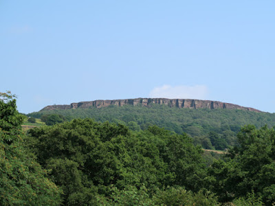
| A symmetrical ridge capped by a bed of sandstone |
Following on from my investigation of the Sheffield Board Schools in Norton and Lowfield, my next day out to Bretton Clough with the Sheffield U3A Geology Group was undertaken during a mini heat wave, when temperatures had soared sufficiently to prompt me to purchase a Tilley hat.
Meeting up at the small village of Abney, on the north side of Bretton Clough, we firstly had a quick look at Abney Low in the mid distance, a distinctive local landform composed of the Shale Grit – a thick sequence of sandstones with intervening bands of shale formed by turbidity currents, which is capped by the Kinderscout Grit.
Wherever it is found, the Shale Grit, with its alternating strong and weak beds is very susceptible to landslides and our first stop was to briefly look at the stabilisation works that had taken place on Abney Road, following a landslip in Abney Clough on 8th November 2020.
I was too busy taking photographs to hear the discussion of these repairs, which consists of various concrete drainage channels that are studded with irregular lumps of volcanic green slate from the Borrowdale Volcanic Group, in the English Lake District.
After stopping to look at a roadside exposure of Shale Grit, we carried on along the road to Abney Grange and then stopped to get another view of Abney Low, where the stepped topography resulting from the differential erosion of the alternating sandstone and shales can clearly be seen.
Before dropping down into Bretton Clough, we got our first view of the landforms that had so intrigued me when I first saw them 25 years previously and which I have briefly described in my previous Language of Stone Blog post.
For most of our walks, the Group mainly relies on books such as Rocky Rambles, Rock Trails Peak District, Geologists’ Association publications and other guides produced by various geology groups. I am not sure which one our leader referred to on this occasion, but he then proceeded to briefly explain that the landscape seen in front of us was the result of landslides.
I agreed that the overgrown scar and the irregularly slumped beds beneath the north facing escarpment of Bretton Clough are consistent with several landslips that I had seen in the Peak District; however, I did emphasise that, when seen from a vantage point on the opposite side of the valley, the geomorphology of the landforms look completely different.
As a working geologist, my comments were based on my own observations made in the field and without referring to publications that I have since read, which skirt over the apparently undisturbed strata that are clearly seen in the symmetrical ridges along the west end of Bretton Clough.
Once down in the valley and wandering around various outcrops of sub-horizontal sections of alternating sandstone and mudstone that form the Shale Grit, I stressed that even a down dip rock slide – as seen at Alport Castles and along the Ashop Valley – probably wouldn’t explain the geometry of the numerous landforms that we were passing.
If I still had my compass-clinometer, I would have taken strike and dip measurements at several places along our walk, to emphasise this point but, only having an Estwing hammer, I had to be content with obtaining a sample of the Shale Grit and decided to say no more.
Analyses of the Shale Grit show them to be poorly sorted medium to coarse grained subarkoses, with considerable proportions of plagioclase and alkali feldspars, muscovite mica and significant amounts of heavy minerals, including zircon, garnet, apatite and tourmaline.
The sample I obtained has a dirty brown colour and contains flat shale pellets and has one surface with up to 4 mm of very fine mudstone. It is fine grained, with alteration products of clay minerals, feldspars and iron oxides/oxides forming the matrix.
By the time that we had finished our lunch, the temperature had risen to an uncomfortable level and, with limited shade on the remainder of the planned route, we made a decision to cut the walk short. Without making any attempt to investigate the shales that are exposed in the stream banks along the bottom of the valley, we slowly made our way back up to Abney via Abney Clough.
Finishing much earlier than we had anticipated, someone suggested that it might be a good idea to stop somewhere for a drink, and we ended the day in the beer garden at the Plough Inn, from which there is an excellent view of Millstone Edge.


Do you have any thoughts about the "geometry of the numerous landforms" that you saw?
ReplyDeleteBtw, I understand that it was a hot day but it seems a great shame to have truncated the event. If people bring appropriate clothing and water supplies then I'd have thought it icould happily have continued.
Hi Tim. When I first saw them emerging from the mist 25 years ago, I thought that they must be erosional features, with the obvious landslides occurring at a later date. As for cutting the walk short, most of our group are in their 70's...
ReplyDelete