 |
| A sundial at Abbeyfield House |
The mini heatwave, which coincided with the midweek Sheffield U3A Geology Group trip to Bretton Clough, had subsided by the weekend and I therefore decided to continue with my investigation of the Sheffield Board Schools and to add further photographs to the British Listed Buildings website – starting with the Grade II Listed toll house, dated 1837, on Pitsmoor Road in Burngreave.
 |
| The toll house |
Built in sandstone ashlar with a batted finish, this building replaces an earlier cottage of 1758 and was occupied by the collector of tolls. I didn’t examine the stonework closely but its medium grained texture, iron staining and Liesegang rings are consistent with those in the upper part of the Pennine Lower Coal Measures Formation on the east side of Sheffield.
 |
| The toll house |
The railway had not yet arrived in Sheffield and it is therefore very likely that the stone was quarried nearby and, although there is no longer any evidence of these and I have not seen any documentation, it is quite likely that the stone came from one of the quarries on the Parkgate Rock less than 1 km away to the south-east.

Crossing the road to Abbeyfield Park, Abbeyfield House was originally built in 1850 by the local colliery owner, William Pass, but was then sold and extensively extended and reorientated in 1880. I didn’t closely examine the sandstone on every part of the building but most of the walling looks quite similar to that seen in the toll house.
 |
| Abbeyfield House |
The projecting octagonal plan south-east corner, however, to my eye appears to have much less iron staining and is much more uniform in colour. With so many of the old quarries in Sheffield being closed and landfilled and so few exposures to examine, it is not easy to determine if the stone is taken from different beds or if it comes from a separate quarry.
 |
| Abbeyfield House |
Looking closely at this part of the building, small weathered out ironstone nodules are quite common and, as seen in the Mexborough Rock at St. Margaret’s church in Swinton, these can be a typical characteristic of a sandstone that clearly differentiates it from others.
 |
| The plinth at Abbeyfield House |
The massive uniformly buff coloured sandstone used for the window dressings, band courses and the portico on the south-west elevation looks like one of the medium grained varieties of Millstone Grit that were commonly brought in from Derbyshire, but the plinth is made of a very different grey cross-laminated Coal Measures sandstone.
 |
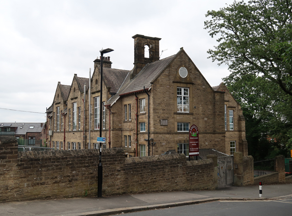
| The original 1893 former Firshill Board School |
Leaving the park and continuing along Barnsley Road, the former Firshill Board School by J.B. Mitchell-Withers, dated 1893, provides further examples of the Crawshaw Sandstone for walling and probably Stoke Hall stone for the dressings, which are the materials favoured in the vast majority of the Sheffield Board Schools that I had seen to date.
 |
| Therear elevation of the 1893 former Firshill Board School |
The architect was also responsible for the Science School extension and the Bow Street Infants’ School at the Leopold Street complex and the now demolished Neepsend Board School. The Jacobean style design here is rather simple, with only the curved gables on the Barnsley Road deviating from the general use of plain gable ends.
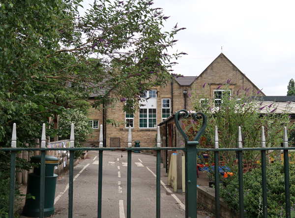 |
| A view of the 1906 extension to the former Firshill Board School |
In 1906, a single storey infants’ school and a caretaker’s house was added by J.R. Wigfull, who worked as an assistant architect at Flockton and Gibbs until 1891, before practising on his own, and whose best known works in Sheffield are probably the notorious Cannon public house and the Thomas Bolsover memorial.
 |
| The caretaker's house |
Carrying on my walk to Shirecliffe Lane, the old boundary walls are built with Greenmoor Rock, which was quarried at the top of the hill at what is now Parkwood Springs. This rock formation has a distinctive fine grained and laminated character and very forms many of the prominent landforms alongside the A61 in Sheffield, to both the south and north of the city centre.
 |
| Greenmoor Rock walling on Shirecliffe Lane |
On the corner of Strutt Road, a pair of very large gate piers, which look to be C18 in style, stand out in an area that is now dominated by interwar houses. Next to it is a lodge, which appears on the 1855 Ordnance Survey map and marks the entrance to the now demolished Shirecliffe Hall.
 |
| Entrance gates to the now demolished Shirecliffe Hall |
At the top of the hill is Shirecliffe House, the last of the listed buildings that I wanted to photograph in Burngreave. Dating to 1840, but restored after bomb damage during WWII, it is mainly notable for providing another example of iron stained sandstone with Liesegang rings, like those that I had seen earlier in the walk.
 |
| Shirecliffe House |
No comments:
Post a Comment