 |
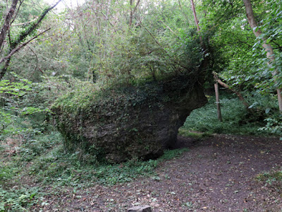
| A large detached block of dolomitic limestone at Markland Grips |
My day out to Palterton and Scarcliffe turned out to be a long but very productive day, which entailed five bus journeys and a good walk – broken up with a couple of pints of Abbot Ale at the Horse and Groom and a pizza while waiting for the X17 bus back from Chesterfield to Sheffield.
I followed this up the next day with a second recce of the Clowne Greenway for the Sheffield U3A Geology Group – to supplement the one that had been undertaken in the week before the COVID-19 Pandemic lockdown in March 2020. Transport on this occasion was provided by Stewart, who I had accompanied on the recce to Lyme Park a couple of weeks earlier.
Although I had gathered enough information on the geology during my previous recce, after leading us around Markland Grips, our local guide Jim had inadvertently taken us back to Clowne along the Linear Park and not via St. John the Baptist’s church as I had planned for my route and I wanted to check that the paths were suitable for the group.
We headed east along the Greenway towards Creswell, only to discover that much of the rock faces were now heavily overgrown but, fortunately, the interesting features that had been highlighted were still visible, including a sandy channel.
When planning our day trips, we always take into account potential hazards, steep climbs or other obstacles that might prove difficult for the group, with the eldest member Pauline – who is in her 80’s but surprisingly able - being typically used as our reference and the point where we left the railway cutting involved a short but steep scramble up rough ground.
Although identified as the only point on the walk where there might be some difficulty for Pauline but, with other group members helping her if required, we considered that it would not be a problem; however, much to our dismay, we found access to the road bridge had been fenced off and that further progress entailed getting through a wire fence and then climbing over a gate.
Knowing that it was possible to continue along the trail and extend our route on the day, we continued to Markland Grips as planned, where we unexpectedly bumped into Marc Pearson, a naturalist in Clowne who had arranged for Jim to be our guide for the recce and the group visit.
Having benefited from this second recce, which included checking another car park a short distance from our planned meeting point, we arrived back in Clowne a few days later, only to find that our first choice of car park was nearly full. Although Stewart was able to meet those members who found it necessary to use this alternative, by the time that we had all gathered together and completed the usual formalities, we were running very late.
We quickly headed off along the section of the railway cutting known as Greenway West, only to find that large sections of this extensive exposure of the Permian Cadeby Formation were thickly overgrown at the end of summer.
With so many of the points of identified 18 months previously obscured, we quickly walked down to the exposure of the Yellow Sands Formation but, with time moving on, we decided not to continue to the exposed coal seam and returned to the remains of the old railway platform, where we had lunch, before then exploring Clowne Crags.
Continuing eastwards along the Greenway until we reached the differentially weathered section of the rock face, which we had interpreted as a stream channel, I collected some of the very fine grained weathered material that I presumed to be sand.
I later looked at this using an Amscope digital microscope, which I had recently bought to examine my growing collections of rocks. Expecting to see irregularly angular quartz, I instead could see very many grains that are rhombohedral – an indication that I was looking at dolomite sand.
Continuing along our diverted route, where we found no geology but did see an egret, we eventually arrived at Markland Grips to find that the limestone crags were also largely obscured, before then heading back towards Clowne and stopping to quickly look at the extensive site of the Markland Grips promontory fort.
With the remains of the embankments on the perimeter of the site obscured by hedges and trees, there wasn’t a lot to see and we therefore continued along the path, where there is a scattering of glaciofluvial pebbles, before finishing our walk by taking a quick look at the building stones at St. John the Baptist’s church.


No comments:
Post a Comment