 |
| A stone on the Millstone Path in the Sensory Garden |
My brief exploration of the interior and exterior of the Church of St. John the Baptist took just under an hour, which left me 45 minutes before the next hourly train back to Sheffield was due to arrive at Penistone railway station.
 |
| The Penistone Conservation Area showing its listed buildings |
I had first visited Penistone back in 2013 to give an illustrated talk for the Penistone PROBUS Club, on the geology and architecture of South Yorkshire, which was held in the St. John’s Community centre opposite the church. After my talk, I walked up to very briefly look at the area around Market Street which, along with the church, forms the focal point of the Penistone Conservation Area and includes the very impressive new timber framed Oak Barn, where the Thursday and Saturday market is held.
 |
| The Oak Barn |
On this occasion, when planning my trip, I discovered that the 14 Listed Buildings in the town centre had already been photographed for the British Listed Buildings website and so I just purchased a pork chop from a local butcher and then had a quick wander around the churchyard and its immediate surrounds.
 |
| The Sensory Gardens |
The Sensory Gardens in St. John's churchyard, with its obelisk designed by pupils at Springvale Primary School with help by local ceramicist Sarah Jones-Morris, is mainly dedicated to Nicholas Saunderson, a blind boy born in Thurlstone in the C17 who, despite all the odds, grew up to become the Lucasian Professor of Mathematics at Cambridge University.
 |
| The obelisk |
The Sensory Gardens also contains the Millstone Path, comprising 10 millstones that have been inscribed with a date that is considered to be a significant moment in Penistone’s history – from the Anglo-Saxon cross dated to c.1000 AD to the building of the Carnegie Free Library in 1931.
 |
| Various stones on the Millstone Path |
In the older part of the churchyard near to the west end of the church, there are two Grade II Listed remains of crosses, one of which consists of a base and part of the shaft and the other being a base only, with both considered by Historic England to be probably late mediaeval in date.
 |
| The remains of stone crosses |
Scattered around the churchyard, there is a crocketted finial, another plain section with a hexagonal plan that appears to be the base of something larger and what could be a large capping to a gatepost, but these are not mentioned in the references to the church history that I have seen.
 |
| A crocketted finial and other sections of masonry |
Leaving the churchyard by its south entrance, both the Penistone Paramount Cinema (1914) and the adjoining Carnegie Free Library are not listed but they are good examples of civic architecture. They have been presumably built with the local Grenoside Sandstone, make a significant contribution to the character of the Conservation Area and the social history of the town.
 |
| The Paramount Cinema and Carnegie Library |
Continuing up Shrewsbury Road to Market Place, Penistone War Memorial (c.1924) has a large winged plinth with a Latin cross placed upon this. Looking at the uniformly buff colour of the sandstone, I think that is from West Yorkshire – perhaps from Bolton Woods from near Bradford or maybe Huddersfield – and the inscriptions on the plinth are cut into volcanic green slate from the Borowdale Volcanic Group in the Lake District.
 |
| Penistone War Memorial |
Opposite the war memorial is the former Cloth Hall (1768) by John Platt of Rotherham, where the severe blackening of much of the masonry can’t hide the yellowish colour of the Grenoside Sandstone with which it has been built.
 |
| The former Cloth Hall |
On the corner of Market Street and St. Mary’s Street is the former National Westminster Bank, with bold rusticated quoins and door and window surrounds. The masonry is a uniform light buff colour and is very probably another example of West Yorkshire sandstone.
 |
| The former National Westminster Bank |
The late C19 former Midland Bank and Bank Chambers on St. Mary’s Street provides another example of uniformly buff coloured medium grained sandstone from West Yorkshire. The Victorian banks were typically built using the best building stones, with the development of the railways – from Manchester along the Woodhead Line in 1845 and Huddersfield in 1851 - providing access to the major stone producing areas.
 |
| The former Midland Bank and Bank Chambers |
Making my way back towards the railway station and passing underneath the railway bridge on Sheffield Road, I stopped briefly to photograph the later C19 Wentworth Court Apartments, which appears to be the hotel that is marked on the 1894 Ordnance Survey map and has a terrace of houses just beyond it.
 |
| The Wentworth Court Apartments |
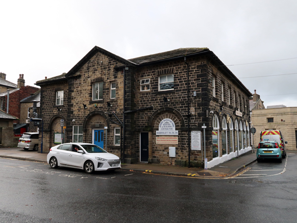
I had never thought of Penistone as being anything else but an upland market town but the opening of two major railway routes transformed it into a major transport hub for passengers and goods – especially coal - and the Camell Laird steel works became the major employer, after it opened in 1863. Although now occupied by various businesses, a quite substantial range of station buildings reflects the growing importance of the town at this time.
 |
| The former railway station buildings |
Arriving at the railway station with a few minutes to spare, I was very interested to see a metal sculpture depicting the Bessemer converter and good quality information boards about the history of the railways and the steel works, as well as information on walks that start from the railway stations along the line, which gave me a few ideas for future days out in West Yorkshire.
 |
| At Penistone railway station |
No comments:
Post a Comment