 |
| Banner Cross Hall |
The field trip to Nottingham in October 2022, with a few core members of the Sheffield U3A Geology Group, proved to be a great day out – with everyone being very impressed by the spectacular outcrops of Triassic sandstone and the historic architecture in the Lace Market.
 |
| The area around Ecclesall, Bents Green and Greystones |
For my next walk, I returned to Sheffield to explore the area around Ecclesall, Bents Green and Greystones and, as was now usual for many of my days out, I took advantage of the British Listed Buildings website Photo Challenge to plan my route.
 |
| The location of Listed Buildings from the Photo Challenge |
Alighting from the No. 81/82 bus at the Ecclesall Road South/Brincliffe Edge Road stop, I took a few quick snaps of the rendered No.14 Ecclesall Road South before heading up to Banner Cross Hall (1821), which I could only photograph with the zoom lens from the entrance to the drive.
 |
| Banner Cross Hall |
I can’t get a proper appreciation the colour variation within the sandstone from these photos, mainly because of the dirt, but I can see that it is built with large ashlar blocks and that restoration work to the castellated parapet has been undertaken with a uniformly buff coloured sandstone.
 |
| The dairy block at Banner Cross Hall |
The Stoke Hall quarry in Grindleford, which according to the Building Research Establishment Report - The Building Sandstones of the British Isles - opened in 1835, has supplied much stone to Sheffield over the years and the King Edward VII Upper School (1838) on Glossop Road is apparently built with gritstone from Hathersage, but it is most likely that either the Chatsworth Grit from the Rivelin Valley or the Loxley Edge Rock has been used here.
 |
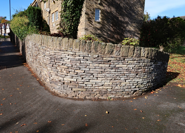
| A section of the boundary wall at Banner Cross Hall |
Moving on to photograph its boundary wall, which is Grade II Listed for its group value, I had expected it to be built with Brincliffe Edge Rock/Greenmoor Rock, a distinctive geological formation that I have seen in very many places in South Yorkshire – both at outcrop and in numerous historic buildings and boundary walls – with the quarries being only 500 metres away as the crow flies.
 |
| A detail of the boundary wall at Banner Cross Hall |
A closer inspection reveals that it looks more like an unnamed silty sandstone from the Pennine Lower Coal Measures Formation (PLCMF), with its grey/light brown colouration with Liesegang rings and very fine cross-laminations, than the Brincliffe Edge Rock.
 |
| An old quarry on the Banner Cross Hall Estate in 1855 |
On the 1855 Ordnance Survey map, a small quarry is marked approximately 500 metres to the south-east of Banner Cross Hall, which is set on one of the unnamed PLCMF sandstones, and may well have been part of the Banner Cross Hall estate - just one of those owned by the Bright family, who originally settled in Whirlow in the C15.
 |
| The geology around the Banner Cross Hall estate |
Continuing to Ringinglow Road, I stopped at the boundary wall to the house at the junction with Ecclesall Road South, where the sandstone looks different to the one seen at Banner Cross Hall and is medium grained and uniform in colour, with massive sandstone used for the coping stones.
 |
| The boundary wall at Ecclesall Road South/Ringlowlow Road |
My next building on my list to photograph was the Grade II Listed Chestnut Cottage (c.1780), a farmhouse and adjoining cottage that forms part of a complex of farm buildings that occupies the plot of land between Dobbin Road and Falkland Road.
 |
| Views of various buldings at the Chestnut Cottage farm complex |
On this occasion, I could just get a glimpse of this over a high garden wall and through the bushes and trees, so I just took a few photos of the various buildings at a distance from Dobbin Road and Falkland Road. The boundary walls are built in thinly bedded Brincliffe Edge Rock, with some iron staining on the joint planes, with the walling stone for the buildings being more massive but with the same colour characteristics.
 |
| A Brincliffe Edge Rock dry stone wall on Ringinglow Road |
When exploring the area around Brincliffe Edge, where there are still a few remnants of the old quarry faces, it is possible to see that there is considerable variation in the thickness of the beds of the Greenmoor Rock/Brincliffe Edge Rock, which would probably account for the same variation seen in the boundary walls.
 |
| A Brincliffe Edge Rock dry stone wall on Ringinglow Road |
No comments:
Post a Comment