 |
| Beeley Brook at the Devonshire Arms |
Over a distance of 500 metres, since leaving St. Anne’s church, I had encountered a wide range of agricultural buildings, attached farmhouses and cottages that varied in age from the mid C17 to the late C19 – all built with locally quarried Ashover Grit with stone slate from Beeley Moor for roofs.
Continuing my walk around the Conservation Area in Beeley, starting at Brookside, the barn to the south of Pynot Cottage dates to the C18 and was built by the 5th Duke of Devonshire around the same time as the Dukes Barn. It is not not listed but, being built with gritstone with stone slate roofs, it adds to the character of Beeley and the Chatsworth Blue paint marks it out as a Chatsworth Estate property.
Turning sharply to the west towards the centre of Beeley, I immediately came across a small bridge over Beeley Brook, which flows down from Beeley Moor to the River Derwent and forms an attractive feature in this part of the village.
Noticing an old wooden gate leading to a public footpath, I followed this for a short distance past a small plantation that I thought might be the site of an old quarry in a small spur that is marked on the geological map as Ashover Grit, which is detached from the main outcrop.
I couldn’t see any rock exposure anywhere but, from this vantage point, I had a good view of Pynot Cottage and the Old Hall. Continuing up the path to open ground, I took a few photographs for a panorama of Burnt Wood, which was where the quarries that suplied building stone for Beeley are located, before retracing my steps to Brookside.
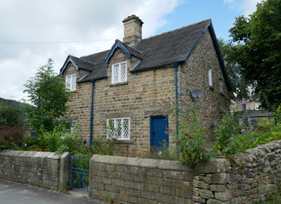
Beeley Brook runs alongside the road and I followed this down Brookside and passed a pair of semi-detached cottages on its north side that appear on the 1883 Ordnance Survey (OS) map, but which the map in the Conservation Area Appraisal marks as C17, C18 and C19 buildings.
Just beyond these is the late C19 Brook House, an unlisted house with two ground floor bay windows that was built sometime between the publication of the first and second editions of the OS maps, which were surveyed in 1879 and 1897 respectively.
A couple of houses have been built to the south side of Beeley Brook, but I didn’t take any note of these at the time and was more interested in the bridges that provide access to them. These include a modern bridge that is not much more than a concrete slab and a much older arched bridge that leads to an unlisted C18 house.
Nos. 1 and 2 Brookside Cottages were designed by G.H. Stokes, who was articled to Sir George Gilbert Scott before joining the architectural design team at the Chatsworth Estate in 1847 and going on to marry Joseph Paxton’s daughter.
Next to these is the mid C19 The Square, which is also by G.H. Stokes and has a Y-shaped plan. Much of Beeley’s architectural interest is derived from the organic development of the buildings, but this is more reminiscent of those seen in the model village of Edensor and Pilsley.
On the opposite side of the road is the Devonshire Arms, which was converted in the mid C18 from three dwellings to a coach-house to serve the turnpike routes. Beeley Brook is culverted here and Brookside opens out to form Devonshire Square, where it meets with Chapel Hill.
The Grade II Listed C18 old post office and Holmes Cottage to the west, which are listed for their group value, occupy the other side of Devonshire Square. I took a few general record photos of these and the adjoining Devonshire Cottage, before taking a short walk up Chapel Hill.
There are no listed buildings here but the Old Smithy and the former Wesleyan Methodist Chapel (1890), which replaced an older chapel that was built further down the hill, are of local historic interest. Another building with Chatsworth Blue paint and an estate design that caught my eye was a building that is named School House, but it is not marked on any maps or referred to in any documentation that I have seen.
The last building on my list for the British Listed Buildings Photo Challenge for Beeley was the late C18 Fold Cottage, which I photographed from the Devonshire Arms car park and from the entrance to the property on Chesterfield Road.
I didn’t venture any further along Chesterfield Road but, except for the village hall on School Lane, these were the only C20 buildings that I had seen on my walk around Beeley, with Nos. 1-4 apparently being built at the end of the 1940s - as ‘Homes for Heroes’ on land given to the Local Authority by the Duke of Devonshire.
Since alighting from the No. 218 bus in Edensor, I had taken photographed several historic buildings in the village, revisited St. Peter’s church, walked through Chatsworth Park to Beeley, where I had also taken a good look at St. Anne’s church – all in 3½ hours without taking a break.
Although it was more than an hour until the next No. 160 bus was due, I went to find the bus stop and was very surprised to see the wonderful bee friendly construction. With the sun starting to shine on what had been a generally cloudy day, it was tempting to spend an hour in the beer garden of the Devonshire Arms, but I settled for a quick pint of Chatsworth Gold before walking back to Chatsworth House.


No comments:
Post a Comment