Thursday, 11 January 2024

St. Lawrence’s Church in Eyam – Part 1

 
The south elevation of St. Lawrence's church

Halfway through my exploration of Eyam’s historic buildings, many of which I photographed for the British Listed Buildings website, I stopped to have a good look at the Grade II* Listed St. Lawrences’s church – described by Historic England as “C13, C15, partly rebuilt 1619. North aisle and chancel restored by Street 1868-69. South aisle and porch rebuilt by J.D Webster, 1882-83.” 
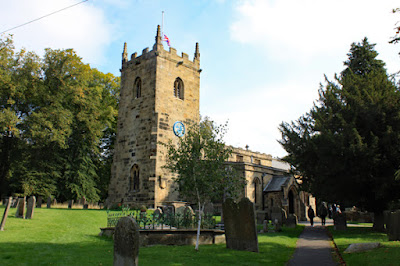
 
A view from the south-west
Entering the churchyard at its south-west corner, I took a couple of quick photographs that shows many of the Perpendicular Gothic features of the church, which includes embattled C15 parapets to the clerestory and tower, grotesques and crocketed pinnacles. 
 
The tower
 
Before starting my survey of the exterior of the church, I wanted to see if I could find either of the Commonwealth War Graves Commission headstones and I took a single photo of the tower on my way to the extensive graveyard to the north of the church. 
 
A view from the north-east

Returning to the church at its north-east corner, even at a distance, the rock-faced gritstone masonry to the tower, which was partly rebuilt in 1619 according to an inscribed stone on the west elevation of the tower, is clearly quite different to the very well squared and coursed Victorian stonework in the north aisle, the vestry and the east wall of the chancel. 
 
A view from the south-east
 
Moving round to the south-east corner, the south elevation of the chancel is clearly part of the C13 church, with its gritstone lancet windows set in coursed and squared Carboniferous Limestone walling, which is clearly distinguished by its grey colour. 
 
The priest's door to the chancel
 
Getting closer to the chancel wall, the priest’s door has a pointed C13 Early English Gothic arch, with a moulded hood and imposts, again made of gritstone that can also be seen as isolated blocks in the adjoining limestone walling. 
 
The sundial on the chancel wall

Above the door is a fine square stone sundial of 1775, inscribed to the top with 'INDUCE ANIMUM SAPIENTEM' and also in a semi-circle round the base of the gnomon, 'Willi Lee and Thomas Froggatt. Churchwardens. Anno X 1775'. 
 
Details of the masonry to the south aisle and chancel
 
The mixed gritstone and limestone rubble masonry to the east end of the south aisle, which the plan in the church guide dates to the C15, is butted against the chancel wall and the masonry surrounding the window was very crudely replaced during the rebuilding of the south aisle in 1883. No attempt has been made to reproduce the pattern of the original masonry and, to the right hand side of the window, the junction is marked by a line of vertically orientated blocks. 
 
The porch

I didn’t take much notice of the Victorian south aisle and just took a photograph of the porch, which was added at the same time, and of a datestone on the west end of the aisle that records the major restoration of 1883. 
 
The datestone at the west end of the south aisle
 
Looking up at the south elevation of the tower, the masonry to the belfry stage above the diagonal buttresses show no signs of blackening, which perhaps marks the point at which the rebuilding of 1619 commenced. Two plaques have been fixed to the lower stage, with the one to the left hand side, dated 1837, displaying advanced weathering where the downflow of water appears to have been concentrated.
 
The south elevation of the tower and a weathered plaque
 
Using my zoom on my Canon Powershot G7X II to see the grotesques, the one on the south-west corner of the tower is highly eroded and the details can’t be determined, but the central figure has sharp details and is a replacement of the original. 
 
Grotesques on the tower

Continuing to the north elevation, beyond the C20 extension, two C13 lancet windows are set into roughly coursed and squared rubble masonry, which is composed of both limestone and gritstone. The south window is dressed with very large blocks of weathered gritstone that contrasts with the north window, which still retains sharp profiles and has possibly been restored. 
 
Lancet windows at the west end of the north aisle
 
I finished my very brief survey of the exterior at the north aisle, which was rebuilt during the 1883 restoration with the windows having Decorated Gothic style geometric tracery. I didn’t examine the stonework, but the lower section of gritstone between the plinth and stringcourse looks different to the stone at a higher level, which has developed a dark patina.
 
The north aisle
 

Tuesday, 9 January 2024

Historic Architecture in Eyam - Part 2

 
A view from St. Lawrence's churchyard

Continuing my exploration of the historic architecture of Eyam, the gritstone water troughs, gatepiers and walls to the south of Eyam Hall were the next structures on my list to photograph for the British Listed Buildings website Photo Challenge. 
 
Walling and water troughs on Church Street

These features, which incorporate a sheep pen in the wall, are listed for their group value and contribution to the historic character of the village. On the opposite side of the road are Delf View (c.1825) and its stables, built of gritstone with traditional stone slate roofs, but its principal elevation is obscured from view. 
 
Delf View
 
Next door to Delf View is another building listed for its group value - the converted C18 barn to the north-west of the Coach House. The gritstone here is, I assume, a further example of the Shale Grit, which I had encountered before at Bretton Clough - in association with the landslides that also occur to the east of Eyam - but I had never knowingly seen as a building stone. 
 
The barn to the north-west of the Coach House
 
Adjacent to the old barn is the late C18 Bagshaw House, described by Historic England as having been re-fronted in the C19, which is again is built with massive gritstone walling and thinly bedded stone slates for the roof. 
 
Bagshaw House

When undertaking research for this Language of Stone Blog post, I discovered that the intermittently active Bretton Moor Quarry, which is less than 2 km to the north-west of Eyam, has been producing stone for roofing for many years. This is quarried from the Shale Grit and it is therefore very likely that this formation has supplied Eyam with its traditional roofing materials. 
 
Plague Cottage and No.1 Church Avenue
 
On the opposite side of Church Street, No. 1 Church Avenue and the adjoining Plague Cottage are both built with Carboniferous Limestone walling, with gritstone quoins and dressings and stone slate roofs. Both date to the C17 and have associations with the Eyam plague, but they were later refaced in the C18 and further altered in the C20. 
 
Nos. 2 and 3 Church Avenue

Nos. 2 and 3 Church Avenue are also dated to the C17 and refaced in the C18, with further connections with the plague. The principal elevations are built in gritstone, with No. 2 having a bull’s eye window, but the gable ends are built with a mixture of limestone and gritstone. 
 
Church Cottage and Church View

I next went to have a good look at St. Lawrence’s church, which I will describe later, but the next buildings on my list to photograph were the early C19 Church Cottage and Church View, included for group value, which were originally two pairs of cottages but one of these has now been converted into a single house. 
 
The front elevation of the Rectory
 
The Rectory is set back in a large garden, with high boundary walls, trees and hedges blocking the view from Main Road; however, after obtaining permission to take a couple of the east elevation from the medical centre next door, using the tilting viewer on my Canon Powershot G7X II to take a shot from above the front and boundary wall and sneaking a little way up the drive, I managed to take a few record photos that would be suitable for the British Listed Buildings website. 
 
The east elevation of the Rectory
 
At first glance, the gritstone construction, stone slate roof and mullioned windows suggest this is another C17/C18 building, like most of the listed buildings that I had seen so far in Eyam; however, the Historic England description states that the house was rebuilt in 1960 and only incorporates a few remains of the earlier C17 and C18 buildings into the fabric. 
 
Stanley House and 10 Church Street etc.
 
Opposite the Rectory is the mid C19 Stanley House, which is again only Grade II Listed for its group value, with No.10 Church Street, Memorial Cottage and the Cottage to the east of these providing yet further examples of the vernacular building materials. 
 
Derwent Cottage and Derwent House

A little further down Church Street at the mid C18 Derwent Cottage and Derwent House, the Venetian windows and the rusticated door surrounds with a tympanum above, which are probably designed by an architect, set this pair of houses apart from the others that I had seen in Eyam. 
 
Mompesson Cottages
 
Taking a short diversion up Glebe Park, the late C18 Mompesson Cottages, with its C19 addition to the west end, was my next stopping point. This pair of cottages provides another example of gritstone and stone slates as the principal building materials, with the mullioned windows on the front elevation being typical of houses of this age – as does the C18 Dale Head on Church Street. 
 
Dale Head

The last building on my list to photograph was the early C19 Fern Lea, again highlighted for group value and set between the pair of Grade II Listed cottages Wayside and Roselyn adjoining to the west and Foresters House to the east. 
 
Fern Lea

It had taken me just under 3 hours to complete my Eyam Photo Challenge and, with 35 minutes before the No. 65 bus back to Sheffield arrived, I found a table in the beer garden of the Miners Arms and discreetly ate my packed lunch with a pint of locally brewed golden ale. 
 
A pint of golden ale at the Miners Arms
 

Historic Architecture in Eyam - Part 1

 
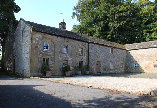
Vernacular architecture at Townhead in Eyam

The logistics of getting to St. John’s church in Ault Hucknall by public transport, with six separate bus journeys and two cross country walks, had been the most complicated since first investigating the mediaeval churches in South Yorkshire and the surrounding counties – starting in February 2016 at St. Helen’s church in Treeton back, which is 150 metres from my house. 
 
A few days later, I set off to the village of Eyam in the Peak District National Park, which is a very popular tourist destination known as the “plague village” but which is also surrounded by some interesting geology, as I had discovered on field trips with the Sheffield U3A Geology Group.
 
My main objective was to visit St. Lawrence’ s church but, as as usual on my days out, I had a list of 27 buildings to photograph for the British Listed Buildings website and, alighting from the No. 65 bus at the Town Head stop a few hundred metres west of the village, I started at the Grade II Listed early C19 Eyam View Farmhouse. 
 
Eyam View Farmhouse
 
This and the U-shaped range of farm buildings are built in Carboniferous Limestone, with Millstone Grit used for the quoins, the window and door surrounds and the three full height, semi-circular headed blind arches, which are its most interesting feature. 
 
The Building Stones Database for England map explorer for Eyam

Looking at the 1883 Ordnance Survey map, the only limestone quarry in the area is set on a knoll reef within the Eyam Limestone Formation, just 200 metres to the south-east of the farm and it is likely that the stone came from here. To the north, the Upper Carboniferous Shale Grit forms a distinct escarpment and the Building Stones Database for England map explorer shows that Bretton Quarry and others worked this formation. 
 
The Townhead silk mill
 
After photographing the other listed buildings, including two pairs of gatepiers, I headed back towards Eyam and stopped briefly at the unlisted former Townhead silk mill (1735), which is built in gritstone, before continuing along Main Road to the Olde House (1615), where gritstone is used again for walling with stone slates for the roof. 
 
The Olde House

Next to the Olde House is the early C17 Merrill House, which has recently had the render removed from the front elevation, along with a C18 outbuilding that is listed for its group value only. Both are built in gritstone - presumably from the Shale Grit - with stone slate roofs and, although I occasionally saw a building constructed with Carboniferous Limestone, it is these materials that give Eyam its essential character. 
 
Merrill House and its outbuilding
 
At a few places on Main Road, for example the former Townend Inn, the Royal Oak and West End Cottage, although the buildings themselves aren’t particularly notable, green information boards that highlight their history have been attached to them. 
 
West End Cottage
 
Carrying on along Main Road, I passed several gritstone buildings of no great architectural merit but, where it turns into Church Street, I stopped at the Courtyard at Eyam Hall, where various shops and places to eat and drink now occupy a couple of Grade II Listed barns and an outbuilding, where both limestone and gritstone has been used for the walling. 
 
The barns and outbuilding to the west of Eyam Hall
 
Although tempted to rest here for a short while, with the bus service back to Sheffield running only every 2 hours, I moved on and then stopped very briefly to photograph the front of the Grade II* Eyam Hall, which dates back to the early C17. 
 
Eyam Hall

Crossing over to the other side of Church Street, I then went to have a look at the village stocks and the old market hall, which now serves as an information centre and various wall panels provide further details of Eyam’s history.

The village stocks and old market hall

Wednesday, 3 January 2024

A Day Out to Ault Hucknall - Part 2

 
The signpost to Doe Lea

From the time of arriving in Ault Hucknall, it had only taken an hour and fifteen minutes to look at the exterior and interior of St. John’s church but, except to take a photograph of the Common Wealth War Graves Commission headstone of Private H. Oliver, of the Oxford and Buckinghamshire Light Infantry, there was nothing else to see in the vicinity and I set off to catch the bus back to Chesterfield.
 
A detail of the headstone of Private H. Oliver
 
When arriving in Ault Hucknall, I had taken the public footpath from Glapwell, which crossed muddy fields where the line of the path had been ploughed so, for my return journey, I decided to take the path that runs down through Hucknall Wood to Doe Lea. 
 
Not long after I had left the main road, I could immediately see that the recently ploughed field to the east of the path exposed a red/brown soil that marks the position of the calcareous mudstone, which forms the base of the Cadeby Formation in this part of North-East Derbyshire. 
 
A field underlain by calcareous mudstone
 
The path follows the north-east edge of an outlier of the Cadeby Formation that has been separated from the main Magnesian Limestone escarpment by ancient tributaries of the River Meden, which flowed east from the watershed and cut down through the limestone plateau. 
 
I continued along the path to the junction between Thompson’s Wood and Hucknall Wood, where it turns to the east and drops down the gentle escarpment. After a short distance, just a couple of metres beneath the level of the field to the south of the wood, I was interested to find a few very small rock exposures of rock beneath the tree roots. 
 
The path through Hucknall Wood
 
Although I did not have my Estwing hammer with me, I was determined to obtain a sample and, after finding a suitably stout piece of branch, I managed to prise out a piece of rock and break it against one of the small exposures. 
 
A small rock exposue

I carried on along the path down through the woods until I reached the western edge of Hucknall Wood, where there are views to the west towards the Pennine Middle Coal Measures Formation strata beyond Doe Lea. 
 
A view from the edge of Hucknall Wood
 
Examining the specimens of limestone that I had collected in the sunlight, both are very dense and contain a significant amount of very fine grained sand, with the larger piece being largely buff to pink in colour. The smaller piece has thin but distinct reddened calcareous mudstone layers, which have differentially weathered in a pattern that is very similar to those seen in the farm buildings and to the C19 restoration work to the north aisle of St. John’s church. 

Samples of sandy dolomite

A couple of years earlier, I had encountered a similar reddened limestone at Palterton and in some of the windows on the west elevation of St. Leonard’s church in Scarcliffe, which lie approximately 3 km to the north. It is very likely the old quarry marked on the 1884 Ordnance Survey map, 400 metres WNW of Ault Hucknall, worked similar stone and it is possible that this may be the source of stone for its farm buildings. 
 
The 1884 Ordnance Survey map