 |
| A detail of the front elevation |
When I first encountered The Ponderosa in Sheffield in the autumn of 2018, I had set out to explore a couple of green spaces that I had identified on Google Map, which I hadn’t visited before – Crookes Valley Park and Ruskin Park.
 |
| A view down Blake Street |
As I subsequently discovered, when unexpectedly encountering Blake Street, the steepest road in Sheffield, the topography - especially the area around Crookes and Walkley that overlooks the Rivelin Valley and the Upper Don Valley – needs to be taken into account when planning walks.

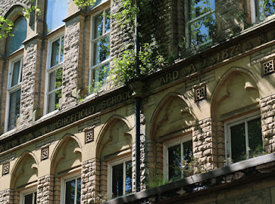
Leaving St. Stephen’s church, my next planned stop was the Grade II Listed former Crookesmoor Board School, which I could see from the path across The Ponderosa, set at the top of the steep dip slope of a narrow ridge of Grenoside Sandstone that runs down to the River Don.

As with the Silkstone Rock and Parkgate Rock that I had encountered at Wincobank and Burngreave Cemetery, the steep south-east dipping strata – measured at 20 degrees to the south of St. Stephen’s church – is related to the asymmetrical anticline known as the Don Monocline.
 |
| The Oxford Street elevation |
Making my way around the tower blocks on the other side of The Ponderosa, which replaced the area of dense terraced housing that existed at the time the Crookesmoor Board School was built in 1874, I was pleasantly surprised to discover so many well established trees – especially since the indiscriminate cutting down of trees in Sheffield’s suburbs had been a big issue in recent years.
 |
| A view down Oxford Street |
From a photographer’s point of view, however, the contrast in light on a very bright late May day - and restricted space - made it very difficult to capture the principal architectural elements in the way that I would have liked to have seen them.
 |
| A detail of the Oxford Street elevation |
Nevertheless, although I could only obtain a few general photographs of the principal Oxford Street elevation from a very oblique angle, I was able to see some of CJ Innocent’s trademark details – including the recessed arches with trefoils and the Sheffield School Board name and date carved in raised lettering on the band course between the two floors.
 |
| A detail of the Oxford Street elevation |
The building has had a recent history of disuse, with the lack of maintenance leading to extensive plant growth along the string courses, although it appears that the gutters and downpipes have not been affected yet.
 |
| The boundary to the 1887 extension on Tay Street |
Part of the walling to the projecting wings of the Oxford Street elevation slopes in the form of a retaining wall, reflecting the topography of the site, which slopes steeply down towards The Ponderosa and also down Crookesmoor Road.
 |
| A crack in the retaining wall on Tay Street |
The slope is particularly noticeable when walking up Tay Street, which has a high retaining wall forming the boundary wall to the school extension, dated 1887, by CJ Innocent when he was working as a sole practitioner. At one place, the wall has been subjected to movement and is pervaded by a large crack.
 |
| School buildings and the caretaker's house on Crookesmoor Road |
I didn’t stop to closely examine the stone that has been used but, seen from a distance, the colour of the rock-faced masonry was consistent with the other board schools that I had seen to date, where Crawshaw Sandstone is used for the walling and Stoke Hall stone for the dressings. Furthermore, the Bolehills quarries in Crookes - the nearest source of good quality sandstone - were just over a kilometre away as the crow flies.
 |
| The 1887 addition to Crookesmoor Road |
No comments:
Post a Comment