Wednesday 31 July 2024

A Day Out to Honley - Part 3

 
The topography around Honley

Arriving at the path leading up to Honley Quarry, I had by now photographed only 11 of the 29 listed buildings that I selected from the results of my British Listed Buildings Photo Challenge for Honley; however, I had walked for more than 3 km since leaving Honley railway station, with the lowest point being 105 m at Honley Bridge and rising to a maximum of 163 m at the corner of Scotgate Road and Hassocks Lane. 
 
My walk from Honley railway station to Honley Quarry
 
The Rough Rock forms a plateau that dips in a north-easterly direction and underlies Honley, with the escarpment above the Mag Brook valley being once extensively quarried at the Scot Gate Head Quarry. I had so far seen many examples of sandstone in the listed buildings and various other cottages, terraced houses and the boundary walls, but I didn't stop to examine it closely. 
 
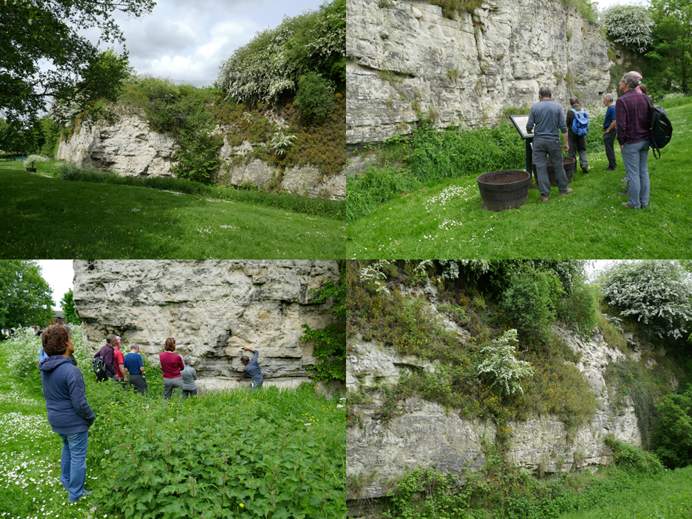
My first view of Honley Quarry
 
The entry for Honley Quarry on the Kirklees Climbing website provides a good introduction to this quarry, with photographs of the various rock faces and routes faced by the climbers who seem to regularly practice their skills here. As a geologist, I just had a short time to look at the principal physical characteristics of the Rough Rock here and take a few record photographs, for examination at a later date. 
 
The north-eastern section of Honley Quarry
 
Entering the quarry, I firstly noticed that it comprises two rectangular pits more than 15 metres deep, which are set at right angles to each other to form an L-shaped layout. Turning into the first smaller north-eastern pit, I could immediately see that the Rough Rock is massively bedded with large scale cross-bedding. 
 
Massively bedded sandstone with large scale cross-bedding
 
The geological memoir (1933) makes several references to the Rough Rock around Honley, describing the Scot Gate Head Quarry as still being operative and producing a very even grained. It goes on to say that it was used widely for public works and buildings in several towns in Yorkshire and Lancashire and, reputedly, it was also used at York Castle. 
 
An extract from the geological memoir describing the Rough Rock
 
I have seen the Rough Rock at a few places in Sheffield, where the formation is flaggy and has been exploited for stone slate roofing and flagstones, but further north in West Yorkshire it can be very coarse grained with fingernail sized pebbles of vein quartz – as I have seen in an old quarry in Roundhay Park and where used as a building stone at Kirkstall Abbey and Leeds Minster. 
 
The location from which a specimen of the Rough Rock was obtained

The specimen that I collected using my Estwing hammer is a fine grained, well bedded sandstone where individual bedding planes can be seen with the naked eye. Iron staining, with the development of Liesegang rings, gives the stone its general colour, but part of the fresh face of the specimen has a distinct blue/grey colour variation – indicating a change in the oxidation state of its iron bearing minerals. 
 
A fresh surface on my specimen of Rough Rock from Honley Quarry
 
Taking a quick look at the jointing pattern in the quarry faces, I noted a few very wide joints that have been partially filled in with squared and coursed stonework, which seemed very strange to me as I can’t think of a reason why this would be done – unless by the climbers themselves, to stabilise sections of the quarry face. 
 
Partially blocked up joints in an old quarry face
 
The geological memoir also describes the strata below the Rough Rock as containing a lot of black and blue shale with ironstone nodules and the high iron content of the sandstone is reflected in its often orange colour – particularly on the joint planes and weathered surfaces. 
 
A weathered surface reveals iron stained sandstone
 
It further mentions that, in some of the quarries, there are numerous large ferruginous spherical concretions that are known locally as ‘mare-balls’. Although I didn’t notice any of these, I did see a couple of places where incoherent sandy masses have been differentially weathered. 
 
A differentially weathered incoherent sandy mass

I spent less than 15 minutes looking around the quarry, which is dominated by exposures of massive cross-bedded sandstone, with the cross-bedding being flaggy in places, but I did not see any of the lower beds that are sufficiently distinctive from the upper massive beds to be mapped separately as the Rough Rock Flags.
 
A view of the south-east quarry face
 

Monday 29 July 2024

A Day Out to Honley - Part 2

 
A view across Mag Brook from Old Moll Road
 
On the first leg of my day out to Honley, for my British Listed Buildings Photo Challenge, I had so far walked just over 3.25 km from the railway station to Clitheroe Farmhouse, but I had only photographed 7 buildings - of which No. 2 Grasscroft Road was the highlight, principally for its large 12-light stone mullioned windows on the first and second floors. 
 
The route of the first leg of my walk.
 
For the next leg of my walk, I continued westward up Scotgate Road to the junction with Hassocks Lane, just beyond which the 1897 Ordnance Survey map shows was the site of the quite substantial Scot Gate Head Quarry.
 
An obscured view of a face of Rough Rock
 
To the north side of Scotgate Road, where the Rough Rock forms an escarpment that drops down quite steeply to the valley below, I could just see vertical exposures of sandstone that may relate to quarrying but I didn’t investigate. Continuing down Scotgate Road, I looked for exposures on both side of the road, but all I could see was the woodland that covers the lower slopes. 
 
Views of the landscape from Scotgate Road
 
The first building to photograph was the rendered Nos. 14 and 15 Wood Bottom Road, houses that have a C17 or early C18 origin with probably early C19 alterations. I just made a mental note of the stone slate roof and another example of multi-light mullioned windows, which are common in Honley, before carrying on with my walk.
 
Nos. 14 and 15 Wood Bottom Road
 
My next stop was of the late C18 Magdale House on Old Moll Road, which was formerly two dwellings. It is set into the hillside beside the road and, to get the best appreciation of its setting, I had to photograph it from various angles. 
 
Views of Magdale House

Continuing down Lea Lane, the early to mid C19 Mill Building at Cocking Bridge Steps is built in hammer dressed stone, with a stone slate roof and a later C19 addition that has a Welsh slate roof. The Yorkshire Industrial Heritage website includes it in its list of Yorkshire textile mills but makes no mention of its use, although the Ordnance Survey map of 1897 describes it as ‘woollen’.
 
Views of the Mill Building
 
I went to have a quick look at Mag Brook and the bridge that crosses it an elevation of 113 metres, which is 50 metres lower than the starting point of this leg of my walk. Descending from the Rough Rock plateau, we crossed the boundary with the underlying mudstones and siltstones of the Rossendale Formation. 
 
The bridge over Mag Brook
 
Looking at a topographic map of the area, Mag Brook occupies quite a sizeable valley, which would have required a much greater flow of water than seen now to create and, upstream of the bridge, I could just see that the topography to the west is much more imposing. 
 
The topography around Mag Brook

Retracing my steps up Lea Lane, I got another view of the Grade II Listed houses that I had seen earlier on Wood Bottom Road, which show them to be very substantial in nature and again take advantage of the steep slope in their design and provide another example of multi- light windows.
 
A view of Nos 14 and 15 Wood Bottom Road
 
After taking a couple of photos of the valley to the east, which is much shallower than that seen to the west, I headed off along Old Moll Road to the next building on my list to photograph – the Grade II Listed No. 5, described by Historic England as “Formerly 2 handed dwellings now one dwelling. Early C19. Hammer dressed stone. Stone slate roof “. 

No. 5 Old Moll Road

Continuing east, I then went in search of Honley Quarry, but firstly encountered the old Moll Spring Dye Works, which is marked on the 1897 Ordnance Survey map. It is not a listed building and seems to be unoccupied, but nevertheless forms an interesting part of Honley’s industrial heritage. 
 
The former Moll Spring Dye Works

Continuing along the public footpath for a short distance, I soon found the way up to Honley Quarry, which is marked on Google Map as one of the locations on the Kirklees Climbing website. Having researched this further, I knew that I could easily get access to it and so I brought my Estwing hammer with me.
 
At the entrance to Honley Quarry

A Day Out to Honley - Part 1

 
Honley Bridge

On the weekend after my monthly day out with the Sheffield U3A Geology Group, to visit a few sites to the east of Leeds, I returned to West Yorkshire on the train. This time, my intention was to explore Honley as part of the British Listed Buildings Photo Challenge, although I did not expect to be able to visit all of the buildings that came up on the postcode search. 
 
Results of the Photo Challenge for Honley

After a short walk down the hill from the railway station, my first stop was to photograph Honley Mill, which was built in the C18 as a corn mill, with later C19 additions when it was converted into use as a scribbling mill – one of about 20 mills in and around the village that made various textile products during the C19. 
 
Honley Mill
 
Seeing nothing of great architectural interest from a distance, I just took a couple of record photographs before retracing my steps along the Huddersfield Road until I reached the Grade II Listed Honley Bridge (1791) over the River Holme. 
 
Honley Bridge
 
Looking at the geological map of the area around Honley, apart from the Pennine Lower Coal Measures Formation strata along Station Road, the route that I had prepared for my walk is essentially underlain by the Rough Rock. 
 
The 1897 Ordnance Survey map shows the quite substantial Scot Gate Head Quarry to be still operating, with other old quarries marked on the map, and this formation probably supplied stone for most if not all of the historic buildings that I saw on the day. 
 
Views of Far End House
 
Walking up Old Turnpike to the Grade II Listed Far End House, a pair of late C18 houses with hammer dressed walling stone and more massive quoins, I stopped only to take a few general photographs before continuing to Field End (1799), but I didn’t look closely at the stonework of either of these buildings.

Views of Field End

According to the Honley Civic Society, cloth making has been a staple activity in Honley since the C11 and, before the onset of factory production in the Industrial Revolution, the home was often also the workplace. The very distinctive north-country weavers' cottages had practically the whole of the upper floor, the loom shop, occupied by looms and spinning jennies. 
 
No. 2 Grasscroft Road
 
Walking down Stony Lane, which is essentially lined with a wide variety of C20 houses, I continued to No. 2 Grasscroft Road where there is a very large early to mid C19 dwelling and weaving building. Good light was essential in this cottage industry, so long bands of mullioned windows were installed to let in the maximum amount of daylight. 
 
Inter-war semi-detached houses on West Street
 
Continuing along Grasscroft Road, I stopped at West Street to take a couple of photos of the stone built inter-war semi-detached houses, where the ground floor 3-light mullioned windows echo the style of the weavers’ cottages. 
 
Nos. 22-24 Grasscroft Road
 
Nos. 20-24 Grasscroft Road are a much more modest terrace of early to mid C19 two storied cottages, which don’t obviously have a loom shop, but the 3-light mullioned windows have been presumably employed to provide sufficient light to allow some kind of cottage industry to be undertaken in them.
 
The rear elevation of Nos. 22-24 Grasscroft Road
 
Immediately to the north, the wall of Nos. 28-30 are built in a sandstone that seems to be a more thinly bedded variety of the Rough Rock, which is highlighted by the very thick sand and cement pointing, and it is also seen in the boundary walls and the stone slates for the roofs.
 
Nos. 28-30 Grasscroft Road
 
Arriving at Scotgate Road, I turned up quite an obvious slope, where the Rough Rock dips 3 degrees to the east, before stopping briefly to photograph a new housing development, where there is again a strong emphasis on multi-light mullioned windows in the design – even though it is not built inside the Conservation Area.
 
A new housing development on Scotgate Lane
 
Before leaving the village, I had to reach above the boundary wall to take a couple of snaps of the late C18 Clitheroe Farmhouse and its attached barn. Although I got just a partial view, I could see that wide mullioned windows on both floors again provide the house with plenty of light. 
 
A view of Clitheroe Farmhouse and its barn
 

Friday 26 July 2024

A Geology Field Trip in East Leeds

 
Micklebring Quarry

A few days after my trip to Wingerworth in Derbyshire, where I had a good look at the exterior, interior and churchyard of All Saints church and photographed various historic buildings, I headed off to Leeds with the Sheffield U3A Geology Group. 
 
The geology of east Leeds
 
On this occasion, Bill Fraser of the Leeds Geological Association – who had taken us around Roundhay Park in Leeds back in 2021 – had agreed to lead us around four sites to the east of Leeds, where the Carboniferous Pennine Lower Coal Measures Formation (PLCMF) and the Permian Cadeby Formation are exposed. 
 
The road cutting at William Parkin Way

Meeting at The Springs shopping centre car park, next to junction 46 of the M1 motorway, our first stop was at William Parkin Way – a road cutting that was excavated in 2018 and which once created an excellent section through sandstones, siltstones and mudstones of the PLCMF, but which is gradually being overgrown. 
 
Examining rock specimens

Although the vegetation has started to take hold of what would have been quite a spectacular rock exposure, once we all got our eye in, the subtle variations in colour and texture that distinguish them could be quite clearly seen. 

Samples of very fine grained grey sandstone

I collected a couple of samples of very fine grained pale grey sandstone, which has some iron staining in the form of Liesegang rings and, on the thinly bedded specimen, there is carbonaceous material that indicates a coal forming environment. 
 
An old quarry in the Cadeby Formation
 
On the vast majority of field trips, we devise a circular walk that provides the group with some good exercise, as well seeing some interesting geology, but this time the sites were at some distance apart and we returned to our cars and drove to Garforth Garden Centre and walked down to an old quarry in the Permian Cadeby Formation. 
 
A 'hills and holes' landscape
 
Returning to the public footpath, we stopped to look at a ‘hills and holes’ landscape, produced by the waste from the mining of the Yellow Sands Formation, which occurs immediately below the Cadeby Formation, for use as moulding sand in iron foundries. 
 
The escarpment at Roach Hills
 
We were then taken on a quick diversion to the limestone escarpment at Roach Hills, to look at the change in the landscape that occurs at the Carboniferous-Permian unconformity – with good views of the topography and the outliers of the Cadeby Formation in the area around Kippax. 
 
A view from the limestone escarpment
 
As at Roundhay Park, Bill came well prepared with photographs of some quite large fossil Schizodus clams, which can be found after the fields have been ploughed. I was particularly interested in these, as my experience of Permian fossil bivalves and brachiopods was of very small species, whose growth had been very restricted by the hypersaline conditions in the Zechstein Sea where they lived. 
 
Views of the Micklefield Quarry
 
After lunch, we then took another short drive to the Micklefield Quarry SSSI, where there is an excellent section of the dolomitic limestone of the Cadeby Formation – both the lower Wetherby Member and the upper Sprotbrough Member. 
 
Bill showing the position of the Hampole Beds
 
The most interesting feature here is the Hampole Beds, which separate the two members and represent a period when sea levels had fallen and, on the edge of the shallow platform formed in the Zechstein Sea, large shallow lakes and lagoons were formed. In these relatively still waters, very fine grained muddy sediments that include green clay were deposited. 
 
A detail of the Hampole Beds
 
Our final destination of the day was the linear village of Aberford, which I briefly visited back in 2019 during a trip to see All Saints church in Barwick-in-Elmet. Having parked the cars, we firstly had a look at the various textures found in a boundary wall, which is built in dolomitic limestone from the Cadeby Formation. 
 
Examining dolomitic limestone in a boundary wall
 
We finished an excellent day by taking a quick look at the stromatolite algal mats that can be seen in the roadside verge on Cattle Lane. These flat domed structures, which I had previously seen at the South Elmsall Quarry, are formed by the fine calcite mud adhering to the algae and with this growing by new layers repeatedly being added by the same process. 
 
Stromatolite algal mats