The week after I had gone on a recce at Creswell Crags for the April 2023 Sheffield U3A Geology Group field trip, knowing that I wasn’t going to spend a day mainly indoors, I instead made plans to explore the geology at Hartley Brook Dike – a Local Geological Site in Sheffield that is listed on the Sheffield Area Geology Trust (SAGT) website as having public access.
On the 1924 edition of the Ordnance Survey map, revised in 1921, the area around this tributary of Blackburn Brook was countryside with a scattering with farms and cottages but, by the 1949 edition, the area had been overwhelmed by the vast sprawling housing estates that comprise Parson Cross and Shiregreen.
When looking at the 1:50,000 geological map and referring to the accompanying memoir, I expected to see some of the ‘Measures between Grenoside Sandstone and Whinmoor and Mickley Thin Coals’ and the description on the SAGT website refers to the Hartley Brook Dike as comprising the strata above the Penistone Flags.
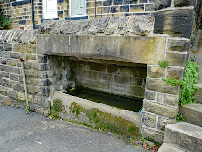
Arriving in Ecclesfield on the No. 83 bus from Sheffield, my first stop was to photograph a water trough on High Street that is presumably is fed by a spring, where the Penistone Flags meets underlying mudstone. On the 1855 edition of the Ordnance Survey map, it is marked as standing in isolation next to a street that was then called Wallet End map but, by the time the 1906 edition was published, it had been incorporated into the boundary wall of the terraced houses that had been built along it.
Crossing over the A6135, I followed the public footpath past the allotments until I reached the footbridge over Hartley Brook Dike, which I then followed south for a few minutes until I found a place where I could get down to the stream bank, where I encountered black shale.
Getting down into the stream bed, the small slabs of flaggy sandstone provided stepping stones that enabled me to take a close look at the section of sandstone, siltstone and mudstone that is exposed in the stream bank.
Just above and below the water's surface, the siltstone has a distinctly orange colour that is not seen at higher levels and reflects a high iron content of the sediment, although I could not see any ironstone nodules.
A little bit further downstream, the dip of the strata brings a thick section of the Penistone Flags to water level, but I could not get close enough to obtain a specimen and therefore retraced my steps to a place when I could chip off a piece of the iron stained siltstone with my Estwing hammer.
I managed to obtained a specimen from these beds but, when I cleaned this, the orange mud washed off to reveal a greyish body to the fresh parts of the siltstone, but with a dark brown patina on the weathered surfaces.
Returning to the path, I continued upstream and in a few places I could see further outcrops of the Penistone Flags forming the streambed and projecting from the banks, but I wasn’t able to get down to the water level to investigate further.
A couple of years earlier, during a walk from Grenoside to Chapeltown, I encountered a small outcrop of the Whinmoor Coal at Charlton Brook when traversing the Penistone Flags, but on this occasion I didn’t see that much variation in the lithologies.
When able to get down to the streambed, I collected a couple more samples, the first being a grey fine grained sandstone with traces of carbonaceous material. The second specimen is a larger piece of grey/light brown flaggy sandstone, which also has carbonaceous material on each of the well exposed bedding planes and also contains roots or stems. It also has a high iron content, with dense concentrations of ironstone appearing in places.
Further upstream, more examples of the Penistone Flags and associated siltstones and mudstones can be seen in the stream banks. As I had seen on previous walks in Shirtcliff Wood and Bowden Housteads Wood, the mudstone has weathered to yellow clay in several places.
The exposures become less frequent as the stream continues to the west and, after taking a couple of photos of the culvert beneath the A6135, I followed the path that crossed this main road and rejoined the stream, which was now named Tongue Gutter.
Up to this point, the stream had flowed through a distinct valley, but from the A6135 to the point where it disappears at Wordsworth Avenue – 1.7 km to the west – this changes in character and the stream barely cuts into the surface; however, although less extensive than the exposures seen along Hartley Brook Dike, further examples of the Penistone Flags and weathered siltstone and mudstone can be seen in several places.
When I first arrived at Hartley Brook Dike, following the recent heavy rainfall, water had been flowing across the footpath path from a spring on higher ground and, when walking up the path at Tongue Gutter, the source of another spring was evident from an area of boggy ground, where the flow of water could be seen.
I followed Tongue Gutter as far as I could before it disappeared beneath a housing estate, after a very enjoyable 3 km walk, during which I had now completed an investigation of nearly all the named sandstone formations in Sheffield.
Firstly taking advantage of the Parson Cross ASDA , I finished my walk by taking a quick look at the public art that is placed on the roundabout and opposite Chaucer School, before escaping from the rowdy schoolchildren and walking down to the next bus stop to get some peace.


No comments:
Post a Comment