Thursday, 31 July 2025

A Walk From Whirlow to Ecclesall

 
An inscribed plaque at the entrance to Parkhead Hall

Setting off on the last leg of a walk that had so far included All Saints churchyard in Ecclesall, the building stones of Bents Green and the geology, geomorphology and historic architecture when walking from Bents Green to Whirlow, I immediately noticed the paving outside the entrance to Whinfell Quarry Garden.
 
The paving outside Whinfell Quarry Garden
"
On the 1854 Ordnance Survey (OS) map, this quarry is specifically marked as producing "Flag Stones" and I strongly suspect that, since they look nothing like the paving stone once quarried from the Greenmoor Rock at Green Moor and Brincliffe Edge, they are an example of locally quarried Rough Rock. 
 
Buildings at the Hollis Hospital
 
Continuing with my British Listed Buildings Photo Challenge, from a distance I took a few photos of the various Grade II Listed buildings forming part of the Hollis Hospital (1903), but these have nothing of interest to this Language of Stone Blog and I carried on along Ecclesall Road South until I came to the next building on my list, Whirlow Court (c.1870). 
 
A gatepier at Whirlow Court
 
Beyond the entrance, with its massive sandstone ornate gatepiers, I could only make out parts of this Tudor Revival style small country house, particularly its crenellated central tower and turret and just took a couple of general record photos. 
 
Whirlow Court
 
I walked for another 500 metres along the road and arrived at Parkhead Hall (1865), where again I could only get partial views of this Grade II Listed country house, with its adjoining stable yard and coach house, from the raised path on the opposite side of the road. 
 
Views of Parkhead House from Ecclesall Road South
 
Originally named The Woodlands and designed in a Gothic Revival style by the Sheffield architect J.B. Mitchell-Withers for his own use and, after his death in 1894, the house was sold to the metallurgist Sir Robert Hadfield, who renamed it Parkhead House and extended it in 1900 and 1903, employing the architects R.G. Hammond of the Strand in London and Wyngard, Dixon & Sandford for this work respectively. 

Boundary walls on Ecclesall Road South

During my walk along Ecclesall Road South from Whirlow Quarry Garden, although I had not been stopping to closely examine the sandstones used in the various boundary walls, I did make a note of their general physical features and the planar bedded sandstone to the parts of Parkhead Hall that I could see and its boundary wall looks similar to the Crawshaw Sandstone that I had seen in very many Sheffield Board Schools and also in Victorian churches. 
 
The Crawshaw Sandstone between Whirlow and Parkhead
 
A disused quarry on the Crawshaw Sandstone was marked on the 1854 6 inch map on a site that the 1894 edition shows as the entrance to The Woodlands; however, at the time the house was built, the Crawshaw Sandstone quarries at Bole Hill were the biggest suppliers of sandstone in Sheffield and Mitchell-Withers would no doubt have previously specified this stone.
 
A view of Parkhead Hall through the entrance gates
 
I could only get a glimpse of the house through the entrance gates, which have massive sandstone gatepiers that I presume to be Chatsworth Grit. After taking a few photos, I then set off down Abbey Lane to find the path through Wood 1 in Ecclesall Woods to Dobcroft Road.
 
The entrance gates at Parkhead Hall

Following the public footpath on the northern perimeter, I encountered one of several streams that flow across the underlying Pennine Lower Coal Measures Formation (PLCMF) strata, where the streambed is littered with blocks of sandstone and weathered mudstone, in the form of yellow clay, is exposed in its banks. 
 
Weathered mudstone and sandstone blocks in a stream

Leaving Ecclesall Woods at the Dobcroft Road entrance, I followed a snicket to Millhouses Lane, where I stopped to photograph Wood Cottage, which was built in the second half of the C19 with what looks to me like flaggy Rough Rock walling and a stone slate roof. 
 
Wood Cottage
 
The boundary wall to No. 230 Millhouses Lane, with its dark brown rather than rusty orange/brown iron staining, looks more like the Greenmoor Rock, which was quarried at Brincliffe Edge. I didn’t examine the stone with a hand lens to determine if it is has a typically fine grained texture and instead was more interested to note the pebbly Chatsworth Grit used for the coping stones. 
 
The boundary wall at No. 230 Millhouses Lane

Retracing my steps to Button Lane, Mylnhust Convent School is set in private grounds and I could not get access but its Grade II Listed lodge (1883), which looks like another example of Crawshaw Sandstone, was easily accessible. 
 
The lodge at Mylnhurst Convent School
 
For this leg of my walk, I didn’t get the opportunity to look closely at the large houses on my Photo Challenge, which would have given a better understanding of the building stones used in this part of Sheffield and I sneaked a look at The Cottage. 

The Cottage

On another good day out in Sheffield, I had traversed the Loxley Edge Rock, the Rough Rock, the Crawshaw Sandstone and minor unnamed PLCMF sandstones, which I assume have all been used locally for boundary walls and that this accounts for the variation in colours and textures that that I had seen, although very few quarries are marked on the old OS maps to give clues to the provenance of the stone used. 
 
A boundary wall on Woodholm Road
 

Sunday, 27 July 2025

A Walk From Bents Green to Whirlow

 
An information board at Whirlow Hall Farm

It only took me 20 minutes to have a quick look at the historic architecture of Bents Green, where the main building stones are the Loxley Edge Rock, the Rough Rock and the Chatsworth Grit. I then set off to find the public footpath to Whirlow and soon came across Thryft House, which was the first building on my British Listed Buildings Photo Challenge. 
 
Thryft House
 
This mid C17 farmhouse and cottage is set below the adjacent lane and a high hedge obscures all but the eaves and the stone slate roof. I sneaked a photo from the entrance and obtained partial views by standing on various walls and fences, which provided information to make the think that this is another example of the use of the Rough Rock for walling and the roof. 
 
Thryft House
 
The public footpath skirts the Castle Dyke playing field, which are set on relatively level ground at an average elevation of about 270 metres that is underlain by the Rough Rock, which dips at 6 degrees to the north-east according to the British Geological Survey map. 
 
A topographic map of the landscape seen from Castle Dyke playing field

Looking to the north-east, beyond the interwar housing of Bents Green, in my photo I can make out Tinsley Viaduct and the Blackburn Meadows Power Station at a distance of 12 km and beyond this along the Don Valley is the Aldwarke steelworks in Rotherham at 18 km, with the hills formed by the Parkgate Rock in the distance. 
 
The view north-east towards Tinsley Viaduct and beyond
 
To the east, at a distance of just over 6 km, the immediately recognisable Herdings Park twin towers are clearly visible on the skyline. Set on an outcrop of an unnamed Pennine Lower Coal Measures Formation (PLCMF) sandstone at an elevation of 228 metres, this distinctive landmark is visible from many parts of Sheffield. 
 
A view of the Herdings twin towers
 
A little further to the north is the Gleadless Valley, where an essentially rural valley cut into the PLCMF mudstones and shales - now drained by the Meers Brook and its tributaries - was transformed by a large scale housing development between 1955 and 1962. 
 
A panoramic view across the Gleadless Valley

Continuing down the path, a dry stone wall is built with a quite thinly bedded sandstone that I wouldn’t quite describe as typically flaggy, but which would be very likely to have been quarried from the Rough Rock at the quarries at Whirlow that mainly produced flagstones, one of which is now the Whinfell Quarry Garden. 
 
A dry stone wall adjacent to the path from Bents Green to Whirlow

Arriving at Broad Elms Lane, I went to find the late C18 Grade II Listed Whirlow Farmhouse, which I could only photograph at a distance from the entrance to its drive. Enlarging my only photo, I can see that most of the walling stone is laid in courses that are of approximately the same size as a brick, but the gable end in the centre of the elevation is built with larger blocks.
 
Whirlow Farmhouse
 
I then continued to the large complex of agricultural buildings at Whirlow Hall Farm, which is now occupied by the Whirlow Hall Farm Trust – an educational charity for inner city children and others that struggle in mainstream education.
 
Whirlow Hall Farm
 
Only part of the complex, which dates back to the late C18 and early C18 with C19 additions, is Grade II Listed and this comprises a cottage, cowshed, a cruck barn and a bull pen and I just took a few general record photographs of these. 
 
The listed buildings at Whirlow Hall Farm
 
I didn’t examine the stone closely with my hand lens but, from my high resolution photos, I can see that the blotchy iron stained walling stone is clearly plane bedded and the thin laminations are quite typical of the Rough Rock that is found in Sheffield. In contrast, the massive quoins and dressings are greyish in colour and are clearly made from the Chatsworth Grit. 
 
A house with pebbly Chatsworth Grit dressings at Whirlow Hall Farm

Leaving the courtyard after taking photos of the listed buildings, I continued up Broad Elms Lane to look at another range of farm buildings that serve various functions for the Whirlow Hall Farm Trust. A substantial house that I though would be listed was the only building that caught my eye, not least for the use of very coarse grained Chatsworth Grit for the main door surround. 
 
A view along Fenney Lane
 
I continued by walking down towards the A625 along Fenney Lane, which is an ancient holloway and, before the construction of a new turnpike road c.1820 at Ringinglow, was one of the main roads out of Sheffield to Fox House and into Derbyshire. 
 
A view towards the Eastern Moors
 
Briefly stopping to take in the view of the Eastern Moors to the south-west, I carried on down Fenney Lane and passed a tree where fine grained flaggy Rough Rock, which in places consisted of poorly cemented orange sand, could be seen exposed beneath its root system. 
 
The Rough Rock exposed beneath tree roots
 
A little further down Fenney Lane, I went into Whinfell Quarry Garden by the top gate with the intention of finding a memorial by Steve Roche, a stone carver and letter cutter who I had proposed for a potential piece of pubic art at Boston Park in Rotherham. The memorial to Stephen Doncaster (d.2018) is made of Woodkirk stone from the Thornhill Rock near Morley, but it was covered in lichens and I could not determine its colour and texture. 
 
The memorial to Stephen Doncaster
 
I had visited Whinfell Quarry Garden a few times before and, through the efforts of the Friends of Whinfell Quarry Garden, it had become more impressive over the years. I had a quick walk around and, apart from seeing the skunk cabbage in flower, I discovered that gypsum has been used in the landscaping and I obtained a couple of loose pieces to add to my growing rock collection. 
 
Specimens of the Rough Rock and gypsum

Friday, 25 July 2025

The Building Stones of Bents Green

 
Bents Green Lodge

After having a walk around All Saints churchyard, to look at its Commonwealth War Graves Commission headstones and various other large monuments, my plan for the rest of the day was to walk up Ringinglow Road to Bents Green, then follow the public footpaths down to Whirlow and finish by making my way back to Ecclesall via Ecclesall Woods. 
 
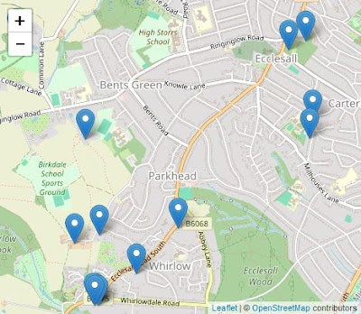
The areas covered during my walk
 
The route of my walk was based on a British Listed Buildings Photo Challenge, which had identified a scattering of buildings in places that I was unlikely to specifically visit or were set in private grounds, where there was no guarantee of obtaining a good view. Nonetheless, some were in parts of Sheffield that I had never been to before and this was a good enough reason to get out of the house for a few hours. 
 
The results of my British Buildings Photo Challenge
 
Leaving the churchyard, I started my walk up Ringinglow Road but, coming to a bus stop and knowing that there was nothing of interest to see here, I took advantage of an imminent No. 88 bus and continued up to Bents Green, where a coffee morning was being held at Bents Green Methodist Church. 

Bents Green Methodist Church

Although it is not listed, it was designed by the Sheffield architect W.J. Hale, who was responsible for the Wesley Hall, St. Luke’s church and the Congregational Church in Crookes and Sheffield Board Schools at Bole Hill, Walkley, Lydgate Lane and Hammerton Street. 
 
The interior of Bents Green Methodist Church
 
During a previous walk from Ecclesall to Bents Green, I had a quick look at the exterior, which is built of very coarse grained Chatsworth Grit with brick dressings. I took a few general record photos of the interior but, with nothing of interest to this Language of Stone Blog, I had a cup of tea and a chat with a few locals before going to have a look at the houses on Trap Lane. 
 
The site of the quarry on Trap Lane

When preparing a report on my last visit to the area, I had looked for quarries on old Ordnance Survey (OS) maps and discovered that a few worked the Loxley Edge Rock around Greystones and, between the publication of the 1855 and 1894 editions, a quarry on the same formation had opened on Trap Lane and presumably supplied the stone for terraced houses that were built during the same period. 
 
Houses on Trap Lane

Of these, only Moor View Terrace and the house on the corner with Latham Square remain, but both have walling that is built with sandstone that is laid in courses that are about the same height as a brick, with only the latter having massive quoins. 
 
The garden wall to No. 258 Ringinglow Road

The boundary walls are built with a similar thin bedded sandstone and, moving back down to Ringinglow Road, the garden wall to No. 258 is built with flaggy sandstone that is often rusty brown coloured. I didn’t look closely at the coping stones, but they are more massive and do not have the same staining and I think that it is likely that these are Chatsworth Grit. 
 
Views of the Hammer and Pincers publc house
 
Continuing along Ringinglow Road for a short distance, I then crossed over to have a look at the Hammer and Pincers public house which, along with Hill Top House and Bents Green Lodge, is one of the very few buildings marked on the 1855 OS map that can still be seen today. 
 
A detail of the outbuilding at the Hammer and Pincers
 
I just took a couple of general photos of the front and rear elevation, which show that the squared but very irregularly coursed walling is composed of a mixture of rusty brown planar bedded sandstone and square blocks of a much more massive gritstone that lacks iron staining. 
 
Quarries in the Rough Rock to the west of Bents Green
 
The outbuilding is built with similar stones and, as with the main building, has a stone slate roof and, looking closely, the quoins are undoubtedly Chatsworth Grit. The Rough Rock was the principal source of stone slates in Sheffield and the centre of production was at the Brown Edge Quarries, which are only 3.5 km to the west, as shown on the Building Stones Database for England map explorer. 
 
The Brown Edge Quarries on the 1858 OS map

The Trap Lane quarry had not yet been opened and the 1855 OS map shows just one old quarry at Greystones, which makes it quite likely that the iron stained walling stone could also be from the Brown Edge Quarries, which the same OS map describes in great detail. 
 
Dry stone boundary walls fronting interwar houses on Ringinglow Road
 
Crossing back over Ringinglow Road, I was quite surprised to see that a few of the later interwar period houses have dry stone garden walls that have been built at a much earlier date. The flaggy sandstone has a high proportion of rusty brown stones that are very similar to those that I had seen in the vernacular architecture and boundary walls around Fulwood and Ranmoor, which I have concluded are built with Rough Rock. 
 
Bents Green Lodge
 
A little further along Ringinglow Road is Bents Green Lodge, which is now used as a children’s home. I only took a couple of photos from the gateway, but these show sandstone ashlar to the elevation surrounding the entrance, which has well developed iron staining and Liesegang rings. 
 
The lodge
 
The house appears on the 1855 OS map and therefore doesn’t come from the Trap Lane quarry but, as with the planar bedded sandstone used for The Lodge, although I think that the dressings are probably Chatsworth Grit, it doesn’t look any of the sandstones that I am familiar with in south-west Sheffield.
 
A detail of the masonry of The Lodge