Friday, 18 February 2022

The Crookesmoor Board School

 
A detail of the front elevation

When I first encountered The Ponderosa in Sheffield in the autumn of 2018, I had set out to explore a couple of green spaces that I had identified on Google Map, which I hadn’t visited before – Crookes Valley Park and Ruskin Park.
 
A view down Blake Street

As I subsequently discovered, when unexpectedly encountering Blake Street, the steepest road in Sheffield, the topography - especially the area around Crookes and Walkley that overlooks the Rivelin Valley and the Upper Don Valley – needs to be taken into account when planning walks.
 
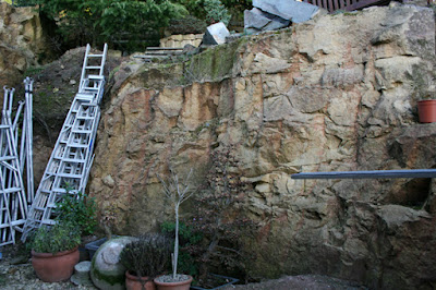
Leaving St. Stephen’s church, my next planned stop was the Grade II Listed former Crookesmoor Board School, which I could see from the path across The Ponderosa, set at the top of the steep dip slope of a narrow ridge of Grenoside Sandstone that runs down to the River Don.
 
As with the Silkstone Rock and Parkgate Rock that I had encountered at Wincobank and Burngreave Cemetery, the steep south-east dipping strata – measured at 20 degrees to the south of St. Stephen’s church – is related to the asymmetrical anticline known as the Don Monocline.
 
The Oxford Street elevation

Making my way around the tower blocks on the other side of The Ponderosa, which replaced the area of dense terraced housing that existed at the time the Crookesmoor Board School was built in 1874, I was pleasantly surprised to discover so many well established trees – especially since the indiscriminate cutting down of trees in Sheffield’s suburbs had been a big issue in recent years.
 
A view down Oxford Street

From a photographer’s point of view, however, the contrast in light on a very bright late May day - and restricted space - made it very difficult to capture the principal architectural elements in the way that I would have liked to have seen them.
 
A detail of the Oxford Street elevation
 
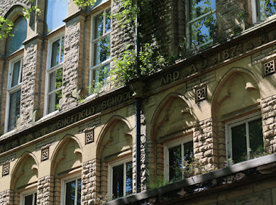
Nevertheless, although I could only obtain a few general photographs of the principal Oxford Street elevation from a very oblique angle, I was able to see some of CJ Innocent’s trademark details – including the recessed arches with trefoils and the Sheffield School Board name and date carved in raised lettering on the band course between the two floors.
 
A detail of the Oxford Street elevation

The building has had a recent history of disuse, with the lack of maintenance leading to extensive plant growth along the string courses, although it appears that the gutters and downpipes have not been affected yet.
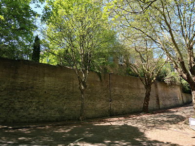
 
The boundary to the 1887 extension on Tay Street

Part of the walling to the projecting wings of the Oxford Street elevation slopes in the form of a retaining wall, reflecting the topography of the site, which slopes steeply down towards The Ponderosa and also down Crookesmoor Road.
 
A crack in the retaining wall on Tay Street

The slope is particularly noticeable when walking up Tay Street, which has a high retaining wall forming the boundary wall to the school extension, dated 1887, by CJ Innocent when he was working as a sole practitioner. At one place, the wall has been subjected to movement and is pervaded by a large crack.
 
School buildings and the caretaker's house on Crookesmoor Road

I didn’t stop to closely examine the stone that has been used but, seen from a distance, the colour of the rock-faced masonry was consistent with the other board schools that I had seen to date, where Crawshaw Sandstone is used for the walling and Stoke Hall stone for the dressings. Furthermore, the Bolehills quarries in Crookes - the nearest source of good quality sandstone - were just over a kilometre away as the crow flies.
 
The 1887 addition to Crookesmoor Road

Monday, 14 February 2022

St. Stephen's Church in Netherthorpe


The next stop during my day out in Sheffield on the last weekend of May 20211, having looked at the principal features of the former Netherthorpe Board School, was the Grade II Listed St. Stephen’s church – built in 1857 to the design of the architects Flockton and Son.
 
A general view from the north-west

As with most Victorian churches, there is very little of archaeological interest in the fabric of the church, with only the new entrance on the north side and the extension to the south-east corner/boundary walling being built in stone that looks different to that used in the original fabric.
 
A view of the south elevation

The cruciform plan and crossing tower of this Gothic Revival style church, coupled with its construction on a steeply sloping site, adds to its architectural interest but I was more concerned with taking a general set of record photos for the British Listed Buildings website on this occasion.
 
A view of the west end

I didn’t look closely at the masonry, but I did note in places that the fine to medium grained walling stone has the grey to brown colour variation seen in formations such as the Silkstone Rock and Parkgate Rock, which did not have reputations for producing the best building stone but were readily available quite locally.
 
Window dressings and headstops on the north aisle
 
The massive uniformly buff coloured massive and medium grained gritty sandstone is consistent with Stoke Hall stone or others quarried from the Ashover Grit around Stanton Moor and Darley Dale in Derbyshire, but petrographic analysis or use of techniques such as X-Ray Fluorescence would be needed to determine its provenance – in the absence of documentary evidence.
 
A headstop carved in gritty sandstone

As with the earlier Christ Church in Burngreave and later, with the Burngreave Cemetery chapels, when practising as Flockton and Lee, I was most interested in the frequent use of carved headstops and have since wondered if this was a characteristic feature of William Flockton’s work.
 
A headstop carved in gritty sandstone

Apart from on Victorian churches and cemetery chapels, I have seen these quite often on houses of various sizes, where they probably would not be expected - including terraced houses - yet very little is known about the sculptors; however, the growth in this trade was such that the Master Carvers Association was formed to uphold the level of training and skills.
 
A war memorial in the churchyard

Sunday, 13 February 2022

The Netherthorpe Board School

 
The Sheffield School Board crest

On the last week of May 2021, a few days after my walk from St. John’s church in Throapham to North Anston, when I had another good look at various buildings of the Permian Cadeby Formation, I turned my attention again to the Sheffield Board Schools.
 
A relief sculpture by Philip Lindsey-Clark

Arriving on the X54 bus from Treeton at Commercial Street, before catching the tram to Netherthorpe Road, I couldn’t resist taking photos of the frieze sculptures by Philip Lindsey-Clark, dated 1938, which adorn the former gas showroom.
 
A relief sculpture by Philip Lindsey-Clark
 
I had become aware of his later work in Sheffield at the Catholic churches of St. Theresa of the Child Jesus at Manor and the Sacred Heart in Hillsborough, where he had had used what looks like Lincolnshire Limestone for his sculptures, but here it is a variety of Portland limestone that has an unusual amount of voids.
 
A general view from Netherthorpe Road

Less than 15 minutes later, I had arrived at the Grade II Listed former Netherthorpe Board School, which was built in 1873 to the design of CJ Innocent, of the Sheffield based architectural practice Innocent and Brown.
 
The principal elevation

Of the board schools that I had seen to date, 9 had been the work of Innocent and I was becoming very familiar with his trademark recessed arched windows, with herringbone masonry details and trefoils and also the Sheffield School Board crest, which depicts the Roman goddess Minerva.
 
The Sheffield School Board crest on the main gable

As with the other schools that I had seen at Carbrook, Pye Bank and Springfield for example, the school was subsequently extended in 1878 and again in 1884 when Innocent continued as a sole practitioner after the death of his partner.
 
The caretaker's house on Dover Street
 
The extensions, including a caretaker’s house, are built in a much simpler style that reflects the dismissal of Innocent as a retained consultant and the award of design contracts being subject to open competition among architects such as Edward Robson and others.
 
A general view from the north-west

Excluding the Central Schools centred on Leopold Street, this was the 18th school that I had visited in the past 3 months and having seen Crawshaw Sandstone and Stoke Hall stone used for the walling and dressings in some of these, as well as in other buildings, I think that it is likely that this combination of stones has been used at the Netherthorpe Board School.
 
A general view of the principal elevation

Certainly, the sandstone does not look like the other principal building stones seen in Sheffield – the Rivelin Grit, Loxley Edge Rock, Greenmoor Rock, Grenoside Sandstone, Silkstone Rock and Parkgate Rock; however, although fairly consistent in colour and texture and very often having the distinct buff colour and planar bedding associated with the Crawshaw Sandstone, in some places there are inconsistencies.
 
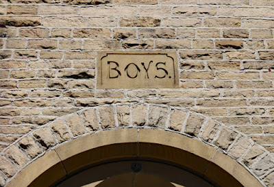
The entrance for boys
 

The North Anston Conservation Area

 
The Grade II Listed Gate House on The Green

Leaving Greenlands Park at the main entrance on Quarry Lane, having obtained a couple of small samples of stone from the old quarry face, I arrived at the northern boundary of the North Anston Conservation Area, which contains a few listed buildings that I wanted to photograph for the British Listed Buildings website.
 
North Anston Conservation Area

Walking down The Green, many of the houses have high garden walls, which block views and I could only see parts of the building where they face directly onto the road or get glimpses of whole elevations through open gates.
 
A view down The Green

All of the houses are built in the yellowish local dolomitic limestone from the Cadeby Formation, which is well squared and coursed, with a mixture of red clay pantiles, grey concrete pantiles and Welsh slate used for the roofing materials.
 
The east elevation of No.18 The Green

Except for the east elevation of No. 18 The Green, whose oldest parts date to the C17 and have some fine mullioned windows typical of the period, I didn’t get the opportunity to see any interesting architectural features and carried on down to a large green, which has stone cottages on three of its sides.
 
Houses surrounding The Green

Continuing down the path to the south-west corner of The Green, I reached the edge of the Magnesian Limestone escarpment, with the land falling sharply to the south and from here there are views over the rooftops to South Anston, where the escarpment continues to Kiveton Park and beyond to Derbyshire and Nottinghamshire.
 
A panoramic view towards South Anston

Descending the path to Hillside, despite the steep slope here, a number of houses have been squeezed in either side of the road and, on a LIDAR map, several distinct scars can be seen in the land, which suggest that quarrying here may have predated the building of the houses.
 
Views of Hillside

On Main Street, the slope of the land is again emphasised by a high retaining wall, which runs along the north side of the road for over 100 metres, above which more stone houses have been built and with a drop to its south side.
 
The retaining wall on Main Street

Walking further down Main Street, there is a mixture of older and modern housing, with some agricultural buildings, which are built in the local vernacular style of limestone with red pantiles. Although adding to the general character of the Conservation Area, with the exception of the Grade II Listed Lodge Farmhouse, none of the buildings have particular architectural merit.
 
A view along Main Street

Retracing my steps along Main Street, I then carried on until I reached The Wells which, as the name suggests, is the site of a spring that seeps out of the hillside and was once the water supply for the inhabitants that lived in the oldest part of the village.

The spring on The Wells

I followed the channelled stream to the point on The Wells where it disappears beneath the houses and turned south to follow the path towards South Anston where, after about 100 metres, the stream reappears. Following it down to Anston Brook, I then made my way to the Leeds Arms and, while waiting for the X5 bus, enjoyed a pint of Abbot Ale in the sunshine.

The channelled stream on The Wells

Friday, 11 February 2022

The North Anston Quarries - Part 2

 
A landscaped old quarry in North Anston
 
Back in 1996, when undertaking geological surveys for the South Yorkshire RIGS Group, I encountered an old quarry face below the level of Greenlands Park, but the area has since been developed and access is now only available with the permission of the various landowners.
 
An old quarry face in North Anston (1996)

On the occasion of my walk from St. John's church in Throapham to South Anston in late May 2021, I didn’t go and have another look, but when exploring the area around the housing estate after a visit to Anston Stones Wood in 2014, I got talking to a houseowner on Limekilns who invited me to have a look at the 50 metres long old quarry face in his back garden.
 
Another view of the landscaped quarry
 
The northern part of the garden had been landscaped with blocks of limestone and planting had obscured much of the rock face. In the southern part, although it was still full of builder’s plant associated with the new house that was just being completed, a good section of massive limestone, with beds at least 50 cm thick, could be clearly seen.
 
A panoramic view of the southern part of the old quarry face

The long history of extensive repair to the fabric of the Palace of Westminster has been the source of considerable debate, with a lack of supervision and quality control at the quarry and unfamiliarity with Anston stone by the London stonemasons often being cited as reasons for its failure.
 
A view of the old quarry face

I only spent 10 minutes having a quick look at the old quarry face – where drill holes for plug and feathers are preserved - and taking a set of record photographs, without closely studying the physical characteristics of the stone; however, it was enough to see that even in the most massive beds, there are patterns of fracture that would be considered undesirable in a building stone.
 
Drill holes for plug and feathers

In plain ashlar masonry, as seen in the keep of Conisbrough Castle and at Brodsworth Hall, this is unlikely to have a great effect on its durability; however, elaborately ornamented Gothic Revival style detailing greatly increases the surface area exposed to the elements – which includes any natural defects within the stone.

A lower level exposure with fracturing in the rock face

The North Anston Quarries - Part 1

 
Rubbly dolomitic limestone at Greenlands Quarry

During my planned walk from Laughton-en-le-Morthen to South Anston, I had so far encountered many historic buildings constructed in dolomitic limestone from the Permian Cadeby Formation at St. John’s church, the hamlet of Throapham and in Dinnington Conservation Area.
 
Continuing south from Dinnington towards North Anston along Nursery Road (B6060), I turned off to have a quick look at Greenlands Park, a public green space and playing fields set next to part of the escarpment that was once extensively quarried for lime and building stone - including that used to rebuild the Palace of Westminster in London, after it burned down in 1834.
 
A LIDAR map of the old quarries in North Anston
 
The area covered by quarries and limekilns was clearly marked on the 1950 edition of the Ordnance Survey map, but it was redeveloped for housing during the later part of the C20. Although only glimpses of the quarry face can now be seen in the back gardens of houses on Limekilns, a LIDAR map clearly shows the position of old workings.
 
An exposure of limestone in Greenlands Park (2014)

In Greenlands Park, the extensive southern 3 metre high face of the Greenland Quarry can still be seen and, although much of it has become quite overgrown since I first visited it in December 2014, there are plenty of good exposures where a geologist can study its details.
 
A section of the Greenlands Quarry face

The lowest part of the section exposes a metre of massive limestone that in my opinion, having surveyed very many stone built historic buildings and worked as a building restoration contractor, would probably provide stone that is suitable for general building.
 
An exposure of dolomitic limestone in Greenlands Park (2021)

The strata above it, however, rapidly change to irregular and occasionally rubbly beds, generally no more than 50-100 mm thick and these would have only be suitable for burning to produce lime and would not have been suitable for building stone.
 
A detail of the dolomitic limestone (2021)
 
The specimens I obtained are yellowish in colour and finely granular when viewed with a hand lens and contain many fine black specks that are probably manganese oxide minerals, like I have encountered before at Cadeby Rattles and Warmsworth Park in Doncaster.

Samples of dolomitic limestone obtained from Greenlands Park