Tuesday, 12 October 2021

Quaternary Geology in Rotherham


Rocks collected on the walk from Kiveton Park to Todwick

On a few occasions, when exploring the area around the Chesterfield Canal during the summer of 2020, I came across places on the Magnesian Limestone where the fields were strewn with rounded and sometimes faceted pebbles of Carboniferous sandstone.
 
These are not marked as superficial deposits on any map, but the Geological Survey of Great Britain memoir, published in 1957, mentions in the introduction to Pleistocene and Recent deposits that there are “a scattering of pebbles to show where more substantial deposits must have been” – with these being found on high ground.
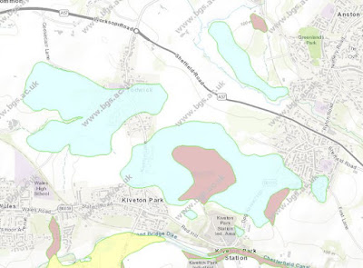
 
Superficial deposits in the area around Kiveton Park

For my next day out, following my investigation of the Treeton Rock, I planned a walk that followed various public footpaths across a part of rural Rotherham, where the British Geological Survey map shows that the bedrock is covered in till and head - laid down during the Quaternary Period.
 
An Ordnance Survey map showing footpaths around Kiveton Park
 
In the area covered by the Sheet 100 Solid and Drift 1:50,000 geological map, less than a handful of sections of till had been recorded, with it being mostly necessary to map the till by observing areas of clayey soil with concentrations of erratics.
 
The public footpath to South Anston

Arriving on the X54 bus at the stop nearest to Kiveton Farm Fisheries and walking east towards South Anston, the ploughed fields presented a featureless landscape that sloped up to the Magnesian Limestone escarpment in the distance; however, there was no sign of the typically reddened soil from the underlying bedrock, which here is Rotherham Red sandstone.
 
An exposure of loamy soil adjacent to the footpath
 
At the edge of the well used wide track, which has been repaired/reinforced in brick and possibly other materials, bare patches of light brown loamy soil are seen to contain numerous pebbles of various shapes and sizes – most of which looked similar to the Carboniferous sandstone pebbles that I had previous seen and interpreted as being glaciofluvial in origin.
 
Loamy soil with abundant pebbles

Carrying on along the track, looking in the soil that could be seen beneath the crop that was now growing in mid-March, within a few minutes and over a short distance, I also found pebbles of vein quartz, red and brown quartzite and others that I thought might possibly be igneous - and pieces of granite and volcanic green slate that are probably building materials.
 
A broken pebble of quartzite
 
Their polished nature makes it difficult to positively identify these pebbles and, although one that I was able to break open with my Estwing hammer was revealed to be a quartzite, others would not break under sustained hammer blows.
 
An old quarry at Kiveton Park

I then took a diversion to Lodge Hill Pond, where a large erratic of volcanic agglomerate from the Lake District had been recorded, but I couldn’t find it and continued south to quickly look at the old quarry to the north of Kiveton Park station, before returning back to the track to South Anston. 
 
Fragments of Rotherham Red sandstone in ploughed soil

I had so far crossed over the areas of both till and head, without seeing any difference between them - which may be possible when crops are not growing. Turning northwards onto the path that marks the boundary between Anston and Todwick, I noticed that the pebbles had disappeared, the reddened soil above the bedrock had reappeared and the only rock fragments visible were small pieces of Rotherham Red sandstone exhumed by ploughing. 
 
Fragments of Rotherham Red sandstone
 
Arriving at the path that runs eastward into Axle Lane and South Anston, I followed it to the west and, after stopping to photograph the Magnesian Limestone escarpment to the north, I carried on along the path next to the ploughed field until I reached Todwick.

A view north towards the Magnesian Limestone escarpment

Tuesday, 5 October 2021

An Investigation of the Treeton Rock

 
A specimen of Treeton Rock

On the anniversary of the COVID-19 Pandemic Lockdown in the UK, on 15th March 2021, there was still no sign of being able to continue with my investigation of mediaeval churches or go out with the Sheffield U3A Geology Group; however following on from my brief visit to Shirtcliff Wood, a late afternoon break in the weather enabled me to investigate some more local geology.
 
A temporary exposure of Treeton Rock on Church Lane

When coming back from St. Helen’s church in Treeton, I had noticed that the uppermost beds of the Treeton Rock were exposed in a building site on Church Lane. I therefore decided to go and have another look at an exposure of this sandstone, which I had discovered several years earlier, when exploring a disused railway line that once led to the Tinsley marshalling yard.
 
An exploration of the Treeton Rock

Now only referred to as an unnamed Pennine Middle Coal Measures Formation sandstone on the British Geological Survey map, the Treeton Rock forms a distinctive escarpment that runs from Swallownest to Treeton, before being breached by the River Rother at Catcliffe.
 
The outcrop of the Treeton Rock
 
Although only a small outcrop, generally no more than a metre thick, except for the temporary exposure that I had seen in the new Jones Homes development during a recent walk around Treeton, it is the only exposure of Treeton Rock that I know and it has some interesting features.
 
An outcrop of Treeton Rock

Unlike the cross-bedded sandstone that I had seen in a few historic buildings and various boundary walls in the centre of Treeton, the sandstone here is generally very flaggy and micaceous, with fine cross-laminations and ripples being common.
 
An outcrop of Treeton Rock
 
Weathering of the sandstone has certainly increased the general friability of the outcrop, especially the thin flaggy beds, but I was a little surprised to discover that I couldn’t easily obtain a small sample of the more massive sandstone with my Estwing hammer.
 
Obtaining a sample of Treeton Rock

The printed BGS map shows three measurements of the dip of the strata around Treeton, from 5 to 10 degrees, and the apparent dip in the cutting to the disused line appears to be consistent with these measurements. My compass-clinometer was stolen many years ago, but several bedding planes are exposed where a measurement of the dip and strike could easily be made.
 
An exposure in the disused cutting showing the apparent dip

Having made my observations and also collected a specimen of markfeldite, which is used ubiquitously in the UK for railway track beds, I made my way back home via Church Lane. Here, I obtained another sample from the above mentioned building site and took a few photographs of a retaining wall, where Treeton Rock is mixed with Rotherham Red sandstone.
 
Treeton Rock and Rotherham Red sandstone

Arriving home, after spending not much more than an hour in the sunshine, I then took a few minutes to clean the specimens that I had collected – together with a piece of Crawshaw Sandstone - ready for labelling and cataloguing.
 
Cleaning my rock samples

The Geology of Shirtcliff Wood - Part 3

 
A sample of weathered mudstone from Shirtcliff Brook

At the end of week 51 of the COVID-19 Pandemic, having recently had a good look at the historic architecture and building stones of Crookes and Walkley, I took advantage of a mild Sunday afternoon at the beginning of March to further investigate the geology of the Shirtcliffe Valley.
 
An exposure of an old stream bed in Shirtcliff Brook
 
A couple of months earlier, I had a good look at the exposures of the various Pennine Middle Coal Measures Formation strata in the bed and banks of Shirtcliff Brook and, before the undergrowth reappeared in force, I wanted to see if I could get down into the streambed and obtain a sample of the very coarse sediment that had been laid down in the Holocene Epoch.
 
An outcrop of Woodhouse Rock along The Edge

Realising that I would need Wellington boots to further explore this section of the brook, I gave up on this idea and headed up to a part of the Shirtcliffe Valley that is known as The Edge, where I had previously seen a few small exposures of a sandstone formerly named the Woodhouse Rock.
 
An exposure of Woodhouse Rock

Scrambling up to the most easily accessible of these, I could quite clearly see the difference between the fine grained sandstone and the silty sediment that lies beneath it – with the subtle variations in the grain size and bedding being highlighted by differential weathering.
 
Ripple bedded siltstone
 
Gaining access to the higher exposure, which is not as easy as it looks, this variation is much more pronounced – with the thinly bedded sandstone here being deeply undercut to reveal a siltstone that contains very distinct ripples.
 
A sample of Woodhouse Rock from The Edge

After collecting a piece of sandstone with my Estwing hammer, I then proceeded along the path below the escarpment, passing exposures of slightly more massive sandstone that I had not seen during my visit the previous summer. I saw no sign of the quarry that was marked on old maps and carried on to the Shirtcliff Brook in Smelter Wood, where a footbridge crosses over it.
 
An outcrop of more massive Woodhouse Rock
 
Immediately downstream of the footbridge, there are good exposures of siltstone and mudstone in the stream banks and streambed, which are much more accessible than the exposures seen much further downstream in Shirtcliff Wood.
 
A streambed exposure of mudstone
 
Although I needed to take care when getting in and out of the brook, I was able to make my way along the streambed without the need for Wellington boots and, with my hammer in hand, I soon found a suitable place from which to obtain a sample.
 
A sampled streambed exposure of mudstone

Having chipped off a piece of mudstone from just below the water’s surface, I pulled it apart to reveal a deep orange gelatinous substance full of iron oxides/hydroxides - breakdown products of the weathered mudstone that I had not encountered before.
 
A sample of mudstone

After discovering that I could easily crumble the mudstone with my fingers, I decided not to collect a specimen on this occasion and went to have a look at the exposures a little further upstream, which have turned into yellow clay – a common feature of the stream banks where the fine grained Pennine Coal Measures Group strata are exposed.
 
An outcrop of mudstone weathered to yellow clay
 
In other locations, the coarser grained grey siltstone looks very similar to the walling stone that surrounds the south door at St. Mary’s church, which has also been used for boundary walling in nearby Handsworth; however, I again didn’t collect a sample and carried on upstream to have another look at the small outcrop of the Swallow Wood coal seam.

An outcrop of the Swallow Wood coal seam

Friday, 1 October 2021

From Howard Road to Mushroom Lane

 
A specimen of Greenmoor Rock from Mushroom Lane

During my exploration of Crookes and Walkley, in the north-western part of the city of Sheffield, I had traversed the Crawshaw Sandstone, the Loxley Edge Rock and the Rough Rock, in addition to the mudstones and siltstones of the intervening Pennine Lower Coal Measures Formation strata.
 
I had seen several examples of the Crawshaw Sandstone in the larger historic buildings, with a distinctive uniform pale buff colour and well defined horizontal bedding. Although the 1855 Ordnance Survey map shows a couple of quarries on the Loxley Edge Rock in Lower Walkley, this area had been covered in housing by the time of the 1894 edition and the Bole Hill Quarries had grown substantially.
 
A sandstone built terrace in Walkley
 
On my walks, I didn’t take any time to look closely at the very many terraced houses and shops that I passed by, but I did notice variations in the colour, iron content and the bed height of the walling stone – all of which would be expected in any named rock formation in the Pennine Coal Measures Group.
 
St. Joseph's Chapel

Taking a diversion off Howard Road, I had a quick look at St. Joseph’s Roman Catholic chapel, dated 1870, which was once part of St. Joseph’s Home – an institution that went through various phases of use and had close links to St. Vincent’s church on Solly Street, in central Sheffield.
 
St. Joseph's Chapel

With limited access to this area and with the late afternoon sunshine in February making it very difficult to take good photographs, I didn’t see anything particularly noteworthy in the stonework and retraced my steps to Howard Road.
 
A fracture in the boundary wall on Fulton Road
 
On the way, however, I was very interested in the retaining wall on Fulton Road, which formed the boundary to  St. Joseph's Home. Apart from showing distinct signs of structural movement, which had required the insertion of tie rods and anchor plates, it provides an example of another rock formation – the Greenmoor Rock.
 
Tie rods and anchor plates on Fulton Road
 
Known in Sheffield as the Brincliffe Edge Rock, the best quality laminated sandstone gained a national reputation for the paving stones and monuments that were made from this very durable stone – with it also being widely used locally for kerbs and road setts; however, the siltstone grade rock is only suitable for basic walling and boundary walls, as seen here.
 
The former St. Joseph's School

Arriving back on Howard Road, I looked down to the former St. Joseph’s School – which was built on land owned by St. Joseph’s Home by an unknown architect; however, the statue of St. Michael slaying Satan is apparently by the York sculptor - George Walker Milburn.
 
The statue of St. Michael
 
Walking quickly down to Crookesmoor, I stopped to take a photograph of the monumental Crookes Valley Methodist Church without having a good look at the stonework, which was bathed in the late afternoon sunshine, before carrying on down to Crookes Valley Park.
 
Crookes Valley Methodist Church

The park is set on siltstone and mudstone, which forms a vale between the dip slope of the Loxley Edge Rock to the north and an escarpment of Greenmoor Rock to the south, which here dips 25 degrees to the south-east. Making my way up this escarpment, I then stopped at a very small outcrop beneath the boundary wall at the top of Mushroom Lane.
 
A small outcrop of Greenmoor Rock on Mushroom Lane

Using my new Estwing hammer, I obtained a sample of the Greenmoor Rock, which here is a grey/green very fine grained silty sandstone, with one surface covered in dark brown iron oxides/hydroxides that often form along the joint planes.

A specimen of Greenmoor Rock

An Exploration of Walkley - Part 3

 
The pediment of the former Ebenezer Primitive Methodist Church

The next planned stage of my exploration of Walkley, having had a look at the former Walkley Board School, was to walk up Freedom Road to South Road and then head back towards Sheffield via Howard Street, where I had identified various historic buildings that I intended to photograph for the British Listed Buildings website.
 
The former Freedom Road Baptist church

Freedom Road is laid out on another long steep hill and, except for briefly stopping to look at the old Baptist church built of very pale well bedded sandstone – which I assumed to be another example of the Crawshaw Sandstone from Bole Hill in Crookes – I didn’t look closely at the sandstone used in some of the Victorian terraced houses.
 
The former Ebenezer Primitive Methodist Chapel
 
Finally arriving at South Road, I continued south-eastwards until I came to the very imposing Grade II Listed former Ebenezer Primitive Methodist Chapel, on the corner with Greenhow Street, which was built in an Italianate style in 1890 to a design by WJ Taylor – another architect from Sheffield whose work I had not encountered before.
 
The former Ebenezer Primitive Methodist Chapel

The sandstone used here is again uniformly pale buff in colour, with distinct horizontal beds, but without obvious iron staining or banding. The rock-faced walling stone is laid in thin courses, with the massive sandstone for the dressings appearing comparatively grey in colour, where weathered.
 
The current Ebenezer Methodist Church
 
To the rear of the church, on Greenhow Street, there is another chapel dating to 1904, which was formerly the Sunday School. The walling stone is very similar to that seen in the main building and, based on my observations of the buildings in Crookes and Walkley to date, I would again tentatively identify this as another example of Crawshaw Sandstone.
 
A detail of the current Ebenezer Methodist Church
 
The walling stone is quite clean and the original colour is revealed, but the dressings are very blackened and it is not easy to assign a potential provenance to this stone. Although Stoke Hall stone from Derbyshire has been recorded in many historic buildings in Sheffield, others from the Ashover Grit around Darley Dale and Stanton Moor are very similar in appearance - as is 'Huddersfield stone'.
 
The former St. Mary's National School

Continuing on to Howard Road, the east elevation of the former St. Mary’s National School - built in a Gothic Revival style in 1871 with later additions - was deeply in the shade, but these same general colours and patterns within the stonework were still evident.
 
The tower of St. Mary's church

Immediately adjacent is St. Mary’s church, built in 1869 to a design by John Grey Weightman, who was previously in partnership with Matthew Ellison Hadfield. Historic England have suggested that he was also responsible for the National School and, although the architectural styles are quite different, the materials used in their construction are very similar.
 
St. Mary's church on Howard Street
 
Again not knowing this architect and being unable to identify design features that are a characteristic of his work, I just took a few photos of the church and the simple Creetown granite Walkley war memorial at its south-east corner, before carrying along Howard Road.
 
Walkley war memorial