Tuesday, 8 February 2022

The Dinnington Conservation Area

 
The remains of a mediaeval cross on Laughton Road

Looking at the 1903 Ordnance Survey map, the area between the hamlet of Throapham and the village of Dinnington, which grew up around Dinnington Hall, had remained essentially unchanged since the 1854 map was published.
 
The 1903 Ordnance Survey map of Dinnington and Throapham

It was only after Dinnington Main Colliery started operating in 1902 that the rapid development of housing and associated leisure and amenity facilities took place and, when walking up Laughton Road from Coronation Park, the most interesting architectural details that I saw mostly relate to this period of growth.
 
Architectural details on Laughton Road
 
The vast majority of the buildings are constructed in brick, with occasional terracotta dressings and stone was generally reserved for inscriptions on such buildings as the branches of the Handsworth-Woodhouse Industrial Co-operative Society and the Masbro’ Equitable Pioneers' Society.
 
The beginning of the Conservation Area at Barleycroft Lane

On the few occasions that I had visited Dinnington before, I was waiting for a bus at this important local transport hub and I have always thought that, like places such as Maltby, Goldthorpe and Mexborough in South Yorkshire, it was very run down and undesirable but, at Barleycroft Lane, the character of the town changes completely.
 
Houses on Barleycroft Lane

The boundary of Dinnington Conservation Area coincides with a change to the typical vernacular architecture associated with the Magnesian Limestone, where the walls are built in yellowish dolomitic limestone and red pantiles are used for the roofs
 
Views of Dinnington Hall Farmhouse

A little further up the gradual hill that corresponds with the undulating escarpment here, I then came across a large plot of land where unknown buildings next to the Grade II Listed Dinnington Hall Farmhouse had been demolished.
 
Dinnington Conservation Area

Next to Dinnington Hall Farmhouse, the remains of the Grade II Listed mediaeval cross are now set behind iron railings outside Falcon Court, having been moved here back in 2011; however, on the Rotherham MBC map of the Conservation Area, the location of this isn't very clear.
 
The mediaeval cross on Laughton Road

At the top of Laughton Road, the Victorian St. Leonard’s church is set on the junction with Church Lane and is the last of several buildings on the site of the church that was built by William de Warenne, the Earl of Surrey, shortly before his death in 1088, but which burned down c.1318.
 
St. Leonard's church

The church is not listed and, to my mind, doesn’t have great architectural merit. At the time of my visit, it was closed and I just had a quick look at its exterior. Dolomitic limestone from the Cadeby Formation is used for walling stone, but the dressings are Ancaster limestone, with the very distinctive differential weathering of its rippled beds.
 
Ripples in Ancaster stone

With the next stage of my walk to South Anston still to complete, I didn’t spend that much time exploring the Conservation Area and after having a quick look at Church Lane, which runs down the Magnesian Limestone escarpment, I just took a few photos for the British Listed Buildings website.
 
Various buildings on Church Lane

The Grade II Listed former stable block to Dinnington Hall, dated to the late C18, and the house opposite on Church Lane provide further examples of the pink coloured limestone that I had seen earlier in Throapham and during a previous visit to Letwell.
 
Dinnington Hall stable block and Top Farm
 
Old Ordnance Survey maps mark the Red Quarry Plantation on Red Quarry Lane, which is approximately 2.5 km due east of Dinnington Conservation Area. I have surmised that this is the most likely source for the pink stone that frequently occurs in the old buildings of Gildingwells and Letwell and it probably supplied the stone seen in Dinnington too.
 
Pink limestone at Top Farm

The last listed building that I saw, from a distance, was the early to mid C18 Dinnington Hall, by James Paine, with later additions and interiors by John Carr. It was originally built for Henry Athorpe, but it is now a private care home and I was therefore unable to get close up to it. 
 
Dinnington Hall
 

Monday, 7 February 2022

Coronation Park in Dinnington

 
A detail of 'Charge' in Coronation Park

Continuing my planned walk from St. John’s church to South Anston, having had a quick look at the historic buildings in the hamlet of Throapham, I arrived on the outskirts of Dinnington – a small town that was originally a small farming community, but which slowly grew with the development of quarrying in the area and then rapidly with the sinking of Dinnington Main Colliery in 1902.
 
Dinnington war memorial

Arriving at Coronation Park, there is a simple war memorial in the form of a Latin cross at its entrance, which was unveiled on 12th November 1922. Unlike most war memorials that I have encountered, it is not listed but it provides an example of grey granite from Aberdeen.
 
The Dinnington Main Colliery Memorial

When researching my day out, I had discovered that a more recent memorial to the coal miners, who had died and worked at Dinnington Main Colliery, had been unveiled on November 24th 2019 and which I particularly wanted to see.
 
The sculpture of 'Charge'

It consists of a statue of a miner named ‘Charge’ and a memorial wall containing the names of men and women who worked at the colliery, which is made in ‘black granite’ that was sourced and worked in China and has both tooled and polished finishes.
 
A detail of the memorial wall

Included in the gardens to accompany the principal memorial wall, there is also a slate covered rose garden with a plaque made of the same polished black granite, which has a dedication with a poem inscribed into it.
 
The rose garden
 
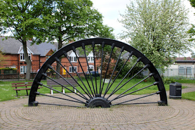
Also in Coronation Park, another commemoration of the colliery, whose closure here in 1992 led to the loss of 1000 jobs and long term devastation of the local economy, is part of the headstock – the winding gear at the pit head, which is a feature of all the former coal mining communities.
 
The headstock

Sunday, 6 February 2022

An Exploration of Throapham

 
A glaciofluvial pebble in Throapham

Once I had finished photographing the interior of St. John’s church in Throapham, where my new Canon G7X Powershot camera had worked as well as my previous G16, I had a wander along the path at the side of the church to take a couple of shots of its exterior.
 
 
Here, I found yet another scattering of glaciofluvial pebbles, such as I had encountered on several walks undertaken in rural Rotherham in the past year during the COVID-19 Pandemic – at Letwell, Firbeck, Brancliffe Grange, Thorpe Salvin, Kiveton Park and Todwick.
 
A glaciofluvial pebble in Throapham

My plan for the day was to firstly explore St. John’s church and then follow the Magnesian Limestone escarpment to South Anston, where I would then catch an X5 bus to take me to either Swallownest or Sheffield Interchange and connect with the X54 bus back to Treeton.

A view from the bottom of St. John's Road in Throapham

Continuing down St. John’s Road to the junction with Oldcotes Road, I found more pebbles in the adjoining fields and I could clearly see the low Magnesian Limestone escarpment rising above the relatively low lying land underlain by the Pennine Upper Coal Measures Formation strata.
 
A view towards the Magnesian Limestone in Throapham

As had now become the pattern for the year, I also wanted to contribute further photos to the British Listed Buildings website and I therefore went to have a quick look at Throapham, before carrying on with my walk towards Dinnington.
 
A boundary wall containing pink limestone
 
Walking up the gentle escarpment here, I was interested to see further examples of pink limestone, like I had seen in St. John’s church and, as I had discovered a couple of months earlier at nearby Letwell, this colouration is quite common in the area.
 
Throapham House

The most substantial building in Throapham is the Grade II Listed Throapham House, a substantial plain ashlar house built in the late C18, surrounded by a few stone built cottages and agricultural buildings forming the hamlet that grew up around the now demolished Throapham Manor House.
 
Various buildings in Throapham

On Manor Lane, I encountered an old boundary wall next to the former gateway to the manor house that has the remnants of a stile, which surprisingly still has a wrought iron handrail, which presumably once served the public footpath here.
 
A stile with a wrought iron handrail

Saturday, 5 February 2022

St. John's Church Throapham Revisited

 
A detail of an ornate coffin lid

After 15 months of the COVID-19 Pandemic, the restrictions in place still made it impossible to continue with my general investigations of the mediaeval parish churches in and around South Yorkshire but, following my trip to Keppel’s Column and Caesar’s Camp, I decided to make St. John’s church in Throapham the starting point for my next day out.
 
I first visited this redundant church in 2016, when exploring churches in South Anston and Laughton-en-le-Morthen, but only quickly looked at its exterior. This time, I obtained the combination for the lock from the Churches Conservation Trust and, when looking at the details inside the porch, noticed that some of the limestone was pink – which I later learned is a characteristic of some of the lowest beds of the Permian Cadeby Formation that lie on the Yellow Sands Formation here.
 
A grave slab reset in the porch

Entering the south door, I firstly had a look at the octagonal Perpendicular Gothic style font, made of limestone and comprising traceried panels with a castellated top and, looking down the nave, the arcades dated to c.1200 have cylindrical columns, but the slightly pointed arches indicate a transition from the Norman to the Early English style.
 
A view along the nave to the east

The C15 tower has a very tall arch and the west window is offset from the centre, so that a spiral staircase can be accommodated in the corner and a blocked arch is seen at the end of the north aisle, where the west bay has been truncated by the tower.
 
A view along the nave to the west
 
Looking along the aisles, there are very few features of note, but the masonry to the north wall appears to be interrupted by a course of very thin stones, which may mark a break in building work. Perhaps this is just coincidental or reflects damp in the lower part of the wall, but the limewash has largely fallen off and the yellow colour of the limestone can be clearly seen.
 
Views of the north aisle

Taking a closer look at the arcades, the capitals to the round columns are very simply moulded, with octagonal sections to the north and the only decoration seen is at the east end of the south arcade, where there is badly eroded nailhead decoration.
 
A detail of the nailhead decoration to the south arcade
 
Unusually, the clerestory contains windows on the south side only, which are wide and have three lights and Tudor arches. In the interior, the masonry is seen to be composed of very large well squared blocks that contrast with the older stonework below.
 
The clerestory

Moving through the wide slightly pointed arch into the chancel, which was completely rebuilt in 1709, there are several points of interest to be seen here, although there are no guides available nor does the Churches Conservation Trust website contain much information.
 
A view of the chancel
 
Several grave slabs are set into the floor, which are made of yellowish coloured dolomitic limestone and range in date from the C15 to the C18, with those in front of the altar being in the form of cross slabs, with the earliest one having an inscription in English and not Latin.
 
Cross slabs in the chancel
 
To the north chapel, which is now occupied the organ, the arch has headstops on either side that have lost a lot of their detail. Their noses look like they have been deliberately damaged, which was often inflicted by iconoclasts during the English Civil Wars.
 
Headstops in the chancel

The highlight of the church is the remarkable coffin lid, dated to c.1300, which has ornate foliage carved in high relief but has unfortunately been broken into two pieces. I have not seen anything like this before during my investigations and it certainly makes the church worth a visit.
 
The ornate coffin lid
 

Wednesday, 2 February 2022

Keppel’s Column and Caesar’s Camp

 
Keppel's Column

Shortly after my walk from Rawmarsh to Swinton, when I was dismayed to discover that numerous saplings were growing out of the brickwork of the Rockingham Kiln, I contacted the Rotherham District Civic Society for their views and was pleasantly surprised to discover that it had received funding for its restoration – along with Catcliffe Glass Cone and Keppel’s Column.
 
An isometric section of Keppel's Column

With a bit of research, I discovered that the proposed restoration tied in with Collaborative Connections, a community engagement project aiming to bring together communities, artists and heritage experts, with the Rotherham Museums, Arts and Heritage service being the co-ordinator.
 
A cross section and vertical section of Keppel's Column

When working on short contracts as a geologist at Clifton Park Museum, I had attended meetings about the future of Keppel’s Column with the manager, Steve Blackbourn, and having established a leading building restoration company in London and possessing specialist expertise in stone identification and matching, I could be considered as a heritage expert.
 
An article describing the regeneration of Clifton Park

On this occasion, however, I was more interested in the idea of writing an article about its proposed restoration. After all, as a freelance ‘journalist’, my work had been published in stone trade and professional journals in the UK, the Netherlands, Germany, Poland, Australia, New Zealand, the USA and Russia – including articles about Rotherham for the German StonePlus magazine.
 
An article describing Rotherham town centre

Having seen the market for this work vanish after the global recession in 2008, I thought that it might be a long shot to get my writing work back off the ground, especially when the latest news that I had seen appeared to indicate that work had already commenced on site.
 
A view from Admirals Crest

Not to be deterred, however, after my brief investigation of the unlisted historic buildings in Rotherham, I decided to go and look at the progress at Keppel’s Column for myself and combine it with a brief investigation of Caesar’s Camp in nearby Scholes Coppice.
 
Keppel's Column
 
When I arrived, expecting to see a full scaffold, I was surprised that work had not begun and, talking to a couple of late middle-aged women who were walking their dogs – who said that they liked the idea of the folly being restored but did not want to be disturbed by visitors – it seemed that the attempt to persuade the bats to leave their roost had not succeeded.
 
An information panel

Encouraged by the fact that building work on site had not yet started, I called the project officer on my mobile phone, to briefly explain my professional background and to say that I would like to write an article about its restoration and, if possible, be introduced to the contractor that had been appointed to do the work - just in case they might require some help with finding a stone "to match the existing as closely as possible".
 
A view up Keppel's Column
 
Much to my chagrin, my enquiry was met with complete indifference and by the time the phone call ended, I was left with the distinct impression that unless I signed up as a community volunteer - even though I actually live in Treeton - I would get no further.
 
A detail of stainless steel strapping used to restrain bulging masonry

Feeling quite insulted, I quickly walked down to Scholes Coppice to see if I could find Caesar’s Camp or evidence of ancient ironstone mining, as mentioned in the comments section of the Historic England listing. With heavy rain looking like a certainty, I didn’t deviate from the path and seeing only a ridge like section of ground used by trial bikes, I decided to call it a day and come back when I was in a much better mood.
 
A view in Scholes Coppice

Having managed to get back to the bus stop on Upper Wortley Road without the heavens opening, I discovered that there wasn’t a bus for another hour and I decided to walk down to Kimberworth. On the way, I found another cast iron sculpture by Marcela Livingston, entitled Morris Miner, which put a smile back on my face.
 
Morris Miner